
The Pennines, also known as the Pennine Chain or Pennine Hills, are a more-or-less continuous range of hills and mountains running between three regions of Northern England: North West England on the west, and North East England and Yorkshire and the Humber on the east. Commonly described as the "backbone of England", the range stretches northwards from the Peak District at the southern end, through the South Pennines, the Yorkshire Dales and North Pennines to the Tyne Gap, which separates the range from the Cheviot Hills across the Anglo-Scottish border. South of the Aire Gap is a western spur into east Lancashire, comprising the Rossendale Fells, West Pennine Moors and the Bowland Fells in North Lancashire. The Howgill Fells and Orton Fells in Cumbria are sometimes considered to be Pennine spurs to the west of the range. The Pennines are an important water catchment area with numerous reservoirs in the head streams of the river valleys.

The Pennine Way is a National Trail in England, with a small section in Scotland. The trail stretches for 268 miles (431 km) from Edale, in the northern Derbyshire Peak District, north through the Yorkshire Dales and Northumberland National Park and ends at Kirk Yetholm, just inside the Scottish border. The path runs along the Pennine hills, sometimes described as the "backbone of England". Although not the United Kingdom's longest National Trail, it is according to The Ramblers "one of Britain's best known and toughest".

Rossendale is a district with borough status in Lancashire, England, holding a number of former mill towns centred on the valley of the River Irwell in the industrial North West. Rossendale combines modest size urban development with rural villages and is immediately south of Burnley, east of Blackburn and north of Bolton, Bury, Manchester and Rochdale, centred 15 miles (24 km) north of Manchester.
Bleaklow is a high, largely peat-covered, gritstone moorland in the Derbyshire High Peak near the town of Glossop. It is north of Kinder Scout, across the Snake Pass (A57), and south of the A628 Woodhead Pass. Much of it is nearly 2,000 feet (610 m) above sea level and the shallow bowl of Swains Greave on its eastern side is the source of the River Derwent.

The Rochdale Canal is in Northern England, between Manchester and Sowerby Bridge, part of the connected system of the canals of Great Britain. Its name refers to the town of Rochdale through which it passes.
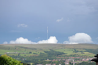
Holme Moss is high moorland on the border between the Holme Valley district of Kirklees in West Yorkshire and the High Peak district of Derbyshire in England. Historically on the boundary between the West Riding of Yorkshire and Cheshire, it is just inside the boundary of the Peak District National Park. The A6024 road between Holmfirth and Longdendale crosses the moor near its highest point close to Holme Moss transmitting station's prominent mast.
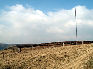
Winter Hill is a hill on the border of the boroughs of Chorley, Blackburn with Darwen and Bolton, in the historic county of Lancashire in North West England. It is located on Rivington Moor, Chorley and is 1,496 feet (456 m) high. Part of the West Pennine Moors, it is a popular walking area, and has been the site of mining activity, aeroplane disasters and murders.

The Pennine Bridleway is a National Trail in Northern England.
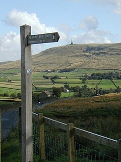
The Mary Towneley Loop is a 47-mile (76 km) circular route that forms part of the Pennine Bridleway National Trail, along the borders of Lancashire and Yorkshire. The loop was opened in 2002, the first section of the Pennine Bridleway.
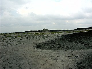
Standedge is a moorland escarpment in the Pennine Hills of northern England between Marsden, West Yorkshire and Diggle, Greater Manchester. Standedge has been a major moorland crossing point since Roman times and possibly earlier.
Boulsworth Hill is a large expanse of moorland, the highest point of the South Pennines of south-eastern Lancashire, England, separating the Borough of Pendle from Calderdale.

The mountains and hills of England comprise very different kinds of terrain, from a mountain range which reaches almost 1,000 metres high, to several smaller areas of lower mountains, foothills and sea cliffs. Most of the major upland areas have been designated as Areas of Outstanding Natural Beauty (AONB) or national parks. The highest and most extensive areas are in the north and west, while the midlands, south-east and east of the country tend to be low-lying.

The South Pennines is a region of moorland and hill country in northern England lying towards the southern end of the Pennines. In the west it includes the Rossendale Valley and the West Pennine Moors. It is bounded by the Greater Manchester conurbation in the west and the Bowland Fells and Yorkshire Dales to the north. To the east it is fringed by the towns of West Yorkshire whilst to the south it is bounded by the Peak District. The rural South Pennine Moors constitutes both a Site of Special Scientific Interest and Special Area of Conservation.

The geography of Greater Manchester is dominated by one of the United Kingdom's largest metropolitan areas, and in this capacity the landlocked metropolitan county constitutes one of the most urbanised and densely populated areas of the country. There is a mix of high density urban areas, suburbs, semi-rural and rural locations in Greater Manchester, but overwhelmingly the land use in the county is urban.

Cowpe is a hamlet in Rossendale, Lancashire, England. It lies in the South Pennines, north of Scout Moor Wind Farm, by the Pennine Bridleway. Rawtenstall is to the west, Bacup to the east and Waterfoot to the north. Directly south over Brandwood and Scout Moors, is Rochdale. 'Cowpe' is thought to derive from 'Cow Pastures'.

The South Pennine Ring is an English canal ring which crosses the Pennines between Manchester and Huddersfield. It covers parts of five canals, and includes passage through the longest canal tunnel in Britain. It has only been possible to cruise it since 2002, when restoration of the Huddersfield Narrow Canal provided the return route across the Pennines.

The North Pennine Ring is a canal ring which crosses the Pennines between Manchester, Leeds and Castleford. It follows parts of five canals, and shares much of its route with the Outer Pennine Ring, which uses a different route for the southern crossing of the Pennines.

The Outer Pennine Ring is an English canal ring which crosses the Pennines between Manchester, Leeds and Castleford. Its route follows parts of eight canals, and includes the longest canal tunnel in England. The ring was completed in 2001, with the opening of the Huddersfield Narrow Canal. Much of the route is shared with the North Pennine Ring, which crosses the Pennines by a different route on the southern leg.

Scout Moor Wind Farm is the second largest onshore wind farm in England. The wind farm, which was built for Peel Wind Power Ltd, produces electricity from 26 Nordex N80 wind turbines. It has a total nameplate capacity of 65 MW of electricity, providing 154,000 MW·h per year; enough to serve the average needs of 40,000 homes. The site occupies 1,347 acres (545 ha) of open moorland between Edenfield, Rawtenstall and Rochdale, and is split between the Metropolitan Borough of Rochdale in northern Greater Manchester and the Borough of Rossendale in south-eastern Lancashire. The turbines are visible from as far away as south Manchester, 15–20 miles (24–32 km) away.

Hameldon Hill is a Carboniferous sandstone hill with a summit elevation of 409 metres (1,342 ft), situated between the towns of Burnley and Accrington in Lancashire, England. It is listed as a "HuMP" or "Hundred Metre Prominence", its parent being Freeholds Top, a Marilyn near Bacup.


