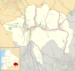
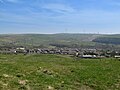
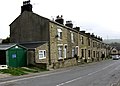
Weir | |
---|---|
Children playing on Weir Park | |
Location within Lancashire | |
OS grid reference | SD870252 |
District | |
Shire county | |
Region | |
Country | England |
Sovereign state | United Kingdom |
Post town | BACUP |
Postcode district | OL13 |
Dialling code | 01706 |
Police | Lancashire |
Fire | Lancashire |
Ambulance | North West |
UK Parliament | |
Weir is a village to the north of Bacup in the Rossendale borough of Lancashire, England, and immediately south of the boundary with the Borough of Burnley. The village had a population of 1,251 at the 2011 Census. [1] Anciently, Weir constituted a hamlet, but later emerged as an outlying suburb of Bacup town after the Burnley Road turnpike was built through the settlement at the end of the 18th Century.
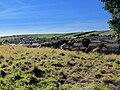
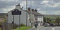
Weir straddles the A671 road and is located by Deerplay Moor, the source of the River Irwell, and adjacent to the parish of Cliviger. Weir is serviced by Northern Primary School in Broadclough, [2] has a church and community centre (the Doals Centre), an award-winning cafe-bar (Anna's), and a Riding Centre (Weir Riding Centre). Weir was previously serviced by two pubs, the Weir Hotel and the New Deerplay in nearby Cliviger (once the 12th highest pub in England at 1,310 ft [3] ). These pubs are set to become business and residential developments. [4] [5]
Weir has an active voluntary group, Weir Pride, [6] which holds monthly meetings and arranges litter picks, floral displays and planting around the village, as well as organising community activities and an annual village fete.
Weir has a football team named A.F.C. Weir, formed in 2010, who compete in the Burnley Miners Burnley and District Sunday league. [7] Their highest finish was second in the 2013/14 season. They also won the Harry Briggs memorial trophy that season, beating Craven 4–0 with two goals each from Luke Dempsey and Ryan Nuttall, Weir goalkeeper Stewart haslam picked up man of the match. They play their home games at Towneley Playing Fields.
There have been several attempts to further develop Weir. The land on the boundary of Weir, adjacent to Broadclough Farm has had several attempts at development including a 61 home plan [8] as well as an 80-bed residential care unit. [9] However to date these have been refused the main concern being loss of the open moorland and countryside surrounding the village.
In June 2014 the police announced they would be monitoring the road between Weir and Bacup (passing through Broadclough) as it had become an accident blackspot. [10] [11]
It is part of the Rossendale and Darwen constituency, with Jake Berry having been the Member of Parliament since 2010.
Michael Carr, a Liberal Democrat politician and former Member of Parliament for the Ribble Valley, is a resident of Weir. [12]
Bacup is a town in the Rossendale Borough in Lancashire, England, in the South Pennines close to Lancashire's boundaries with West Yorkshire and Greater Manchester. The town is in the Rossendale Valley and the upper Irwell Valley, 4 miles (6.4 km) east of Rawtenstall, 6 miles (9.7 km) north of Rochdale, and 7 miles (11 km) south of Burnley. At the 2011 Census, Bacup had a population of 13,323.
Barnoldswick is a market town and civil parish in the Borough of Pendle, in the administrative county of Lancashire, England. It is within the boundaries of the historic West Riding of Yorkshire. Barnoldswick and the surrounding areas of West Craven have been administered since 1974 as part of the modern administrative county of Lancashire. This was when West Riding County Council and Barnoldswick Urban District Council were abolished and the town was transferred to the Borough of Pendle.
Rossendale is a district with borough status in Lancashire, England, located along the River Irwell and spanning a large valley. It is located south of Burnley and east of Blackburn. The borough borders Greater Manchester to the south and borders the boroughs of Bolton, Bury and Rochdale.
The Borough of Burnley is a local government district with the borough status in Lancashire, England. It has an area of 42.7 square miles (110.7 km2) and a population of 94,646 (2021), and is named after its largest town, Burnley. Other notable settlements include Padiham, Hapton, Worsthorne, Briercliffe and Cliviger.
The Rossendale Valley is in the Rossendale area of Lancashire, England, between the West Pennine Moors and the main range of the Pennines. The area includes the steep-sided valleys of the River Irwell and its tributaries, which flow southwards into Greater Manchester. The rivers cut through the moorland of the Rossendale Hills, generally characterized by open unwooded land, despite the ancient designation of "forest".
Whitworth is a town and civil parish in Rossendale, Lancashire, England, amongst the foothills of the Pennines between Bacup, to the north, and Rochdale, to the south. It had a population of 7,500 at the 2011 Census.
Bacup Borough Football Club is a football club based in Bacup, Lancashire, England. The club are currently members of the North West Counties League Division One North and play at West View. They are full members of the Lancashire County Football Association.
Waterfoot is a historic mill town and civil parish in the Borough of Rossendale between Rawtenstall and Bacup in Lancashire, England. The B6238 road from Burnley meets the A681 road, and Whitewell Brook the River Irwell.
The River Calder is a major tributary of the River Ribble in Lancashire, England and is around 20 miles (32 km) in length.
Cliviger is a civil parish in the Borough of Burnley, in Lancashire, England. It is situated to the southeast of Burnley, and northwest of Todmorden. According to the 2011 census, the parish has a population of 2,238.
Worsthorne is a rural village on the eastern outskirts of Burnley in Lancashire, England. It is in the civil parish of Worsthorne-with-Hurstwood and the borough of Burnley. At the 2011 census the village had a population of 1,028.
The A671 is a road in the North West of England, that runs between Oldham, Greater Manchester and Worston, near Clitheroe, Lancashire. Major towns on the route include Rochdale and Burnley. The road is approximately 35 miles (56 km) long. Between Burnley and the A59, the A671 has primary status.
Newchurch is a village within the borough of Rossendale in Lancashire, England. It is around one mile east of Rawtenstall and half a mile north of Waterfoot.
Hapton is a village and civil parish in the Borough of Burnley in Lancashire, England, 3 miles (4.8 km) west of Burnley, with a railway station on the East Lancashire Line. At the United Kingdom Census 2011, it had a population of 1,979.
Habergham Eaves is a civil parish in the borough of Burnley, in Lancashire, England. The parish consists of a rural area south of Burnley, and suburban areas on the outskirts of the town, including a large industrial estate in the north-west corner of the parish. Habergham is also the name of an area west of Burnley, although it is no longer within the parish. According to the United Kingdom Census 2011, the parish has a population of 1,466.
Hameldon Hill is a Carboniferous sandstone hill with a summit elevation of 409 metres (1,342 ft), situated between the towns of Burnley and Accrington in Lancashire, England. It is listed as a "HuMP" or "Hundred Metre Prominence", its parent being Freeholds Top, a Marilyn near Bacup.
Broadclough – historically Broad Clough – is a village located to the north of Bacup, previously having been a part of the old borough of Bacup and now with Rossendale borough of Lancashire and part of the Greenclough Ward. It is part of the Rossendale and Darwen constituency, with Jake Berry having been the Member of Parliament since 2010. Like much of Bacup, Broadclough is rapidly becoming a commuter area for cities and towns such as Manchester, Burnley, Accrington, Preston, Blackburn, Rochdale.
Whitewell Brook is a minor river in Lancashire, England. It is 4.34 miles (6.99 km) long and has a catchment area of 7.67 square miles (19.86 km2).
The Burnley Coalfield is the most northerly portion of the Lancashire Coalfield. Surrounding Burnley, Nelson, Blackburn and Accrington, it is separated from the larger southern part by an area of Millstone Grit that forms the Rossendale anticline. Occupying a syncline, it stretches from Blackburn past Colne to the Yorkshire border where its eastern flank is the Pennine anticline.
Media related to Weir at Wikimedia Commons