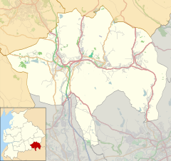
Bacup is a town in the Rossendale Borough in Lancashire, England, in the South Pennines close to Lancashire's boundaries with West Yorkshire and Greater Manchester. The town is in the Rossendale Valley and the upper Irwell Valley, 4 miles (6.4 km) east of Rawtenstall, 6 miles (9.7 km) north of Rochdale, and 7 miles (11 km) south of Burnley. At the 2011 Census, Bacup had a population of 13,323.

Rossendale is a local government district with borough status in Lancashire, England. Its council is based in Bacup and its largest town is Rawtenstall. It also includes the towns of Haslingden and Whitworth. The borough is named after the Rossendale Valley, the upper part of the River Irwell.

Rossendale and Darwen is a constituency in Lancashire represented in the House of Commons of the UK Parliament since 2024 by Andy MacNae of the Labour Party.

Rawtenstall is a town in the borough of Rossendale, Lancashire, England. The town lies 15 miles north of Manchester, 22 miles east of Preston and 45 miles south east of Lancaster. The town is at the centre of the Rossendale Valley. As of 2022, it had a population of 23,000.
Whitworth is a town and civil parish in Rossendale, Lancashire, England, amongst the foothills of the Pennines between Bacup, to the north, and Rochdale, to the south. It had a population of 7,500 at the 2011 Census.
Bacup Borough Football Club is a football club based in Bacup, Lancashire, England. The club are currently members of the North West Counties League Division One North and play at West View. They are full members of the Lancashire County Football Association.

Rosso (Rossendale Transport Limited) is a bus operator providing local services in Greater Manchester, Lancashire and West Yorkshire, England. It is a subsidiary of Transdev Blazefield, which operates bus services across Greater Manchester, Lancashire, North Yorkshire and West Yorkshire.

Rossendale was a parliamentary constituency in the Lancashire, England. Created in 1885, it elected one Member of Parliament (MP) to the House of Commons of the Parliament of the United Kingdom, elected by the first-past-the-post voting system. When created it comprised the districts of Rawtenstall, Bacup, and Haslingden; Ramsbottom district was added to the constituency in 1950.

Weir is a village to the north of Bacup in the Rossendale borough of Lancashire, England, and immediately south of the boundary with the Borough of Burnley. The village had a population of 1,251 at the 2011 Census. Anciently, Weir constituted a hamlet, but later emerged as an outlying suburb of Bacup town after the Burnley Road turnpike was built through the settlement at the end of the 18th Century.

Newchurch or Newchurch in Rossendale is a village within the borough of Rossendale in Lancashire, England. It is around one mile east of Rawtenstall and half a mile north of Waterfoot.

Britannia railway station served Britannia near Bacup, Lancashire, England, from 1881 until closure in 1917. The station was just to the west of the summit of the line, which was also the highest point on the entire Lancashire and Yorkshire Railway (LYR) system.

Bacup railway station served the town of Bacup, Rossendale, Lancashire, England, from 1852 until closure in 1966 and was the terminus of two lines; one from Rawtenstall and the other from Rochdale.
The Rochdale–Bacup line was a branch railway line which ran between Rochdale in Lancashire and Bacup in Lancashire via seven intermediate stops, Wardleworth, Shawclough and Healey, Broadley, Whitworth, Facit, Shawforth, and Britannia.
Gerard Patrick Keenan is an English former footballer who played 240 league and cup games in the English Football League for Bury, Port Vale, and Rochdale from 1975 to 1984. He served Accrington Stanley as player-manager from 1984 to 1986. He later worked as player-manager at Ashton United, Rossendale United and Bacup Borough.

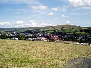
Stacksteads is a village between the towns of Bacup and Waterfoot within the Rossendale borough of Lancashire, England. The population of this Rossendale ward at the 2011 census was 3,789. Stacksteads includes a mountain bike trail called Lee Quarry which had originally been a working quarry.
Broadclough – historically Broad Clough – is a village located to the north of Bacup, previously having been a part of the old borough of Bacup and now with Rossendale borough of Lancashire and part of the Greenclough Ward. It is part of the Rossendale and Darwen constituency, with Jake Berry having been the Member of Parliament since 2010. Like much of Bacup, Broadclough is rapidly becoming a commuter area for cities and towns such as Manchester, Burnley, Accrington, Preston, Blackburn, Rochdale.
The 2015–16 North West Counties Football League season was the 34th in the history of the North West Counties Football League, a football competition in England. Teams were divided into two divisions: Premier Division and Division One.
The 1909–10 season saw Rochdale become champions of the Lancshire Junior Cup. They also came 4th out of 20 in the Lancashire Combination Division 2 and reached the first qualifying round of the F.A. Cup.
The 1911–12 season saw Rochdale compete in The F.A. Cup for the 4th time and reached the fourth qualifying round. The also competed in the Lancashire Combination Division 1 and finished top of the table for the second consecutive season.

Stubbylee Hall, formerly known as Bacup Town Hall, is a former municipal building in Stubbylee Lane in Bacup, a town in Lancashire in England. The building, which served as the offices and meeting place of Bacup Borough Council, is a Grade II listed building.