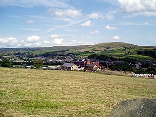
Bacup is a town in the Rossendale Borough in Lancashire, England, in the South Pennines close to Lancashire's boundaries with West Yorkshire and Greater Manchester. The town is in the Rossendale Valley and the upper Irwell Valley, 3.5 miles (5.6 km) east of Rawtenstall, 6.4 miles (10.3 km) north of Rochdale, and 7 miles (11 km) south of Burnley. At the 2011 Census, Bacup had a population of 13,323.

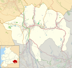
Rossendale is a district with borough status in Lancashire, England, located along the River Irwell and spanning a large valley. It is located south of Burnley and east of Blackburn. The borough borders Greater Manchester to the south and borders the boroughs of Bolton, Bury, Manchester and Rochdale.
Hyndburn is a local government district with borough status in Lancashire, England. Its council is based in Accrington and covers the outlying towns of Clayton-le-Moors, Great Harwood, Oswaldtwistle and Rishton. The borough was created in 1974 and takes its name from the River Hyndburn. It had a population of 80,734 at the 2011 Census. Elections to the council are held in three out of every four years, with one third of the 35 seats on the council being elected at each election. Both the Conservative and Labour parties have controlled the council at different times, as well as periods when no party has had a majority.

The Salford Hundred was one of the subdivisions of the historic county of Lancashire, in Northern England (see:Hundred. Its name alludes to its judicial centre being the township of Salford. It was also known as the Royal Manor of Salford and the Salford wapentake.

Haslingden is a town in Rossendale, Lancashire, England. It is 16 miles (26 km) north of Manchester. The name means 'valley of the hazels' or 'valley growing with hazels'. At the time of the 2011 census the town had a population of 15,969. The town is surrounded by high moorland; 370 m (1215 ft) to the north; 396 m (1300 ft) Cribden to the east; 418 m (1372 ft) Bull Hill to the south.
Ramsbottom is a market town in the Metropolitan Borough of Bury, Greater Manchester, England. The population at the 2011 census was 17,872.
Dunnockshaw or Dunnockshaw and Clowbridge is a civil parish in the borough of Burnley, in Lancashire, England. The parish is situated between Burnley and Rawtenstall. According to the United Kingdom Census 2011, the parish has a population of 185.
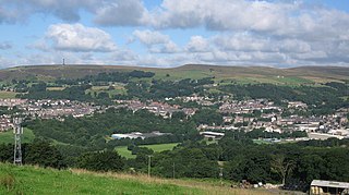
Rawtenstall is a town in the borough of Rossendale, Lancashire, England. The town lies 15 miles/24 km north of Manchester, 22 miles/35 km east of Preston and 45 miles/70 km south east of the county town of Lancaster. The town is at the centre of the Rossendale Valley. It had a population of 23,000.

Belmont is a village in Lancashire, England. It is close to Darwen. It has around 500 inhabitants and lies within the civil parish of North Turton in the unitary authority area of Blackburn with Darwen.
Whitworth is a town and civil parish in Rossendale, Lancashire, England, amongst the foothills of the Pennines between Bacup, to the north, and Rochdale, to the south. It had a population of 7,500 at the 2011 Census.

Aighton, Bailey and Chaigley is a civil parish in the Borough of Ribble Valley in Lancashire, England, just west of Clitheroe. The population of the civil parish at the 2011 census was 1,307, an increase from 1,249 in 2001.

Bowland Forest Low is a civil parish in the Ribble Valley district of Lancashire, England, covering some 5,500 acres (22 km2) of the Forest of Bowland. According to the 2001 census, the parish had a population of 168, falling to 160 at the 2011 Census. The parish includes the hamlets of Whitewell and Cow Ark. From northwards clockwise, it borders the civil parishes of Newton, Bashall Eaves, Aighton, Bailey and Chaigley, Bowland-with-Leagram and Bowland Forest High. Before 1974, it formed part of Bowland Rural District in the West Riding of Yorkshire.

Weir is a village to the north of Bacup in the Rossendale borough of Lancashire, England, and immediately south of the boundary with the Borough of Burnley. The village had a population of 1,251 at the 2011 Census. Anciently, Weir constituted a hamlet, but later emerged as an outlying suburb of Bacup town after the Burnley Road turnpike was built through the settlement at the end of the 18th Century.

Yate and Pickup Bank is a civil parish in the borough of Blackburn with Darwen, Lancashire, England. The population of the civil parish taken at the census of 2011 was 366. The parish contains two hamlets, Bank Fold and Pickup Bank and part of the village of Belthorn which is on the boundary with Hyndburn. It has boundaries with the parishes of Eccleshill to the west and North Turton to the south.

Strongstry is a small hamlet in Rossendale, Lancashire, England. The hamlet is only accessible by an unadopted road running through a factory. It is accessible on several walking routes. For local government purposes, it receives services from Rossendale Borough Council and Lancashire County Council. Nearby are the village of Stubbins and the hamlet of Chatterton. The East Lancashire Railway runs through Strongstry, but there is no station there.
Shawforth railway station served Shawforth near Bacup, Rossendale, Lancashire, England, from 1881 until closure in 1947.

Habergham Eaves is a civil parish in the borough of Burnley, in Lancashire, England. The parish consists of a rural area south of Burnley, and suburban areas on the outskirts of the town, including a large industrial estate in the north-west corner of the parish. Habergham is also the name of an area west of Burnley, although it is no longer within the parish. According to the United Kingdom Census 2011, the parish has a population of 1,466.

Hoddlesden is a village in the borough of Blackburn with Darwen, in Lancashire, England. The village population at the 2011 census was 1,239. It is in the borough's East Rural ward, and is situated east of Darwen. To the north there are the parishes of Eccleshill and Yate and Pickup Bank, to the east there is Haslingden Grane, part of the West Pennine Moors, and to the south-west there is Blacksnape, a small hamlet.

Loveclough is a small hamlet at the edge of the Rossendale Valley, in Lancashire, England, near Crawshawbooth and Rawtenstall, 20 miles north of Manchester, 21 miles east of Preston, and 44 miles south east of Lancaster.

Lumb is a small village in the Rossendale district of Lancashire, England. It lies in the valley of the Whitewell Brook, 3 miles (5 km) north east of Rawtenstall. It should not be confused with the hamlet of Lumb near Edenfield, also in the Rossendale district.