
Lhotse is the fourth highest mountain in the world at 8,516 metres (27,940 ft), after Mount Everest, K2, and Kangchenjunga. Part of the Everest massif, Lhotse is connected to the latter peak via the South Col. Lhotse means "South Peak" in Tibetan. In addition to the main summit at 8,516 metres (27,940 ft) above sea level, the mountain comprises the smaller peaks Lhotse Middle (East) at 8,414 m (27,605 ft), and Lhotse Shar at 8,383 m (27,503 ft). The summit is on the border between Tibet and the Khumbu region of Nepal.

The International Mountaineering and Climbing Federation or UIAA recognises eight-thousanders as the 14 mountains that are more than 8,000 metres (26,247 ft) in height above sea level, and are considered to be sufficiently independent from neighbouring peaks. However, there is no precise definition of the criteria used to assess independence, and, since 2012, the UIAA has been involved in a process to consider whether the list should be expanded to 20 mountains. All eight-thousanders are located in the Himalayan and Karakoram mountain ranges in Asia, and their summits are in the death zone.

Nuptse or Nubtse is a mountain in the Khumbu region of the Mahalangur Himal, in the Nepalese Himalayas. It lies two kilometres WSW of Mount Everest. Nubtse is Tibetan for "west peak", as it is the western segment of the Lhotse-Nubtse massif.
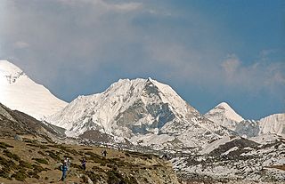
Imja Tse, better known as Island Peak, is a mountain in Sagarmatha National Park of the Himalayas of eastern Nepal. The peak was named Island Peak in 1953 by members of the British Mount Everest expedition because it appears as an island in a sea of ice when viewed from Dingboche. The peak was later renamed in 1983 to Imja Tse but Island Peak remains the popular choice. The peak is actually an extension of the ridge coming down off the south end of Lhotse Shar.

The Khumbu Glacier is located in the Khumbu region of northeastern Nepal between Mount Everest and the Lhotse-Nuptse ridge. With elevations of 4,900 m (16,100 ft) at its terminus to 7,600 m (24,900 ft) at its source, it is the world's highest glacier. The Khumbu Glacier is followed for the final part of the trail to one of the Everest Base Camps. The start of the glacier is in the Western Cwm near Everest. The glacier has a large icefall, the Khumbu Icefall, at the west end of the lower Western Cwm. This icefall is the first major obstacle—and among the more dangerous—on the standard south col route to the Everest summit. It is also the largest glacier of Nepal.

Lhotse Shar is a subsidiary mountain of Lhotse, and the 5.5th-highest mountain on Earth, at 8,383 m (27,503 ft) high. It has the highest fatality rate of all the eight-thousanders – for every two people who summit the mountain, one person dies attempting to. However, this is primarily because most climbers tend to try to ascend to the primary peak of Lhotse, rather than the lowest summit of the mountain. It was first climbed by Sepp Mayerl and Rolf Walter on 12 May 1970.
The Great Himalayas or Greater Himalayas probably is the highest mountain range of the Himalayan Range System. Entities the range is within include Pakistan, China, India, Nepal, and Tibet. The world's highest peak, Mount Everest, and other "near−highest" peaks - K2, Kangchenjunga, Lhotse, Nanga Parbat, etc, are part of the Greater Himalayas range. The total west to east extension of the great Himalayas is 2400 km and their average elevation is 6000 m. They are home to many glaciers like Gangotri Glacier, Satopanth Glacier etc.

Mahālangūr Himāl is a section of the Himalayas in northeast Nepal and south-central Tibet of China extending east from the pass Nangpa La between Rolwaling Himal and Cho Oyu, to the Arun River. It includes Mount Everest, Lhotse, Makalu, and Cho Oyu — four of Earth's six highest peaks. On the Tibetan side it is drained by the Rongbuk and Kangshung Glaciers and on the Nepali side by Barun, Ngojumba and Khumbu Glaciers and others. All are tributaries to the Koshi River via Arun River on the north and east or Dudh Kosi on the south.

Imja Glacier is located in the Himalayas, in the Solukhumbu District of Nepal.

The Kangshung Glacier is one of the three main glaciers of Mount Everest, and is in the Tibet region Himalayas, within the Tibet Autonomous Region of China. The other two are the Khumbu Glacier and Rongbuk Glacier.

Imja Tsho is a glacial lake created after melt water began collecting at the foot of the Imja Glacier on the lower part of the glacier in the 1950s. A 2009 study described this lake of melt water as one of the fastest-growing in the Himalaya. Held in place by a terminal moraine, Imja Tsho threatens downstream communities with the potential for a glacial outburst flood.
Ambulapcha Glacier is a glacier of the Himalayas in the Solukhumbu District of Nepal. It adjoins Imja Glacier to its south and with Lhotse Shar Glacier forms three major glaciers. It forms the Ambulapcha Tsho glacial lake, located at 27°53′35″N86°54′47″E.

Lhotse Shar is a glacier of the Himalayas in the Solukhumbu District of Nepal. It adjoins Imja Glacier to the northeast and with Ambulapcha Glacier forms three major glaciers. To the east is Cho Polu (6734m/22,093ft).
Sepp Mayerl, also known as Blasl-Sepp was an Austrian mountaineer.
Nicolas Jaeger (1946–1980) was a French physician and alpinist.

The Lho La is a col on the border between Nepal and Tibet north of the Western Cwm, near Mount Everest. It is at the lowest point of the West Ridge of the mountain at a height of 6,006 metres (19,704 ft).
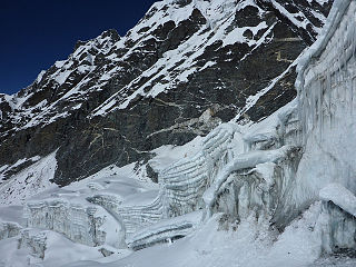
Amphu Labtsa pass, elevation 5,845 metres (19,177 ft), is a glaciated pass covered in serac cliffs at the head of the Honku valley. It provides a way out of the otherwise relatively isolated Honku valley. The base of the valley is at 5,000 m (16,400 ft) and has several glacial lakes including the Panch Pokhri or Five Sacred Lakes. The Amphu Labtsa pass is crossed by mountaineers en route to Island Peak or Baruntse expeditions and involves technical mountaineering. The ice and rock summit is quite exposed and provides good views of Lhotse Shar, Island Peak and the Imja Glacier. The way down into the Imja valley on the other side of the pass involves abseiling followed fixed rope descent. The approximate alpine grade of the Amphu Labtsa pass would be 'D'.
