
Thailand's 514,000 square kilometers lie in the middle of mainland Southeast Asia. The nation's axial position influenced many aspects of Thailand's society and culture—it controls the only land route from Asia to Malaysia and Singapore.

The Chao Phraya is the major river in Thailand, with its low alluvial plain forming the centre of the country. It flows through Bangkok and then into the Gulf of Thailand.
Tak is one of the western provinces (changwat) of Thailand. Neighbouring provinces are Mae Hong Son, Chiang Mai, Lamphun, Lampang, Sukhothai, Kamphaeng Phet, Nakhon Sawan, Uthai Thani and Kanchanaburi. The western edge of the province has a long boundary with Kayin State of Myanmar (Burma).

Kamphaeng Phet is a province (changwat) of Thailand in the upper center of the country. Neighbouring provinces are Sukhothai, Phitsanulok, Phichit, Nakhon Sawan, and Tak.

Lamphun is one of the northern provinces (changwat) of Thailand. Neighboring provinces are Chiang Mai, Lampang, and Tak.

The Xiang River is the chief river of the Lake Dongting drainage system of the middle Yangtze, the largest river in Hunan Province, China. It is the 2nd largest tributary in terms of surface runoff, the 5th largest tributary by drainage area of the Yangtze tributaries. The river flows generally northeast through Guangxi and Hunan two provinces, its tributaries reach into Jiangxi and Guangdong.

Ang Thong is one of the central provinces (changwat) of Thailand. The name "Ang Thong" means "gold basin", thought to have derived from the basin-like geography of the area, and the golden color of the rice grown in the region.
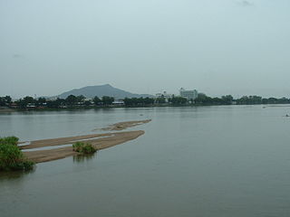
Tak is a town in north-west Thailand, capital of the Tak Province and the Tak district. As of 2005 the town had a population of 19,900 and an area of 7.27 km². It covers the tambon Rahaeng, Nong Luang, Chiang Ngoen, and Hua Diat. It is on the Ping River, 418 km north-north-west of Bangkok.

Wiang Kum Kam is an historic settlement and archaeological site along the Ping River, which was built by King Mangrai the Great as his capital before he moved it to Chiang Mai. It was flooded and abandoned more than 700 years ago; that move became more understandable in 2005, when the ancient city was flooded three separate times as the river overflowed its banks in that area of Chiang Mai.

The 700th Anniversary Stadium is a multi-purpose stadium in Chiang Mai, Chiang Mai Province, Thailand, built to host the 1995 Southeast Asian Games and to commemorate the 700th Anniversary of Chiang Mai's establishment at the same time. It was also used for the 1998 Asian Games. Football side Chiangmai F.C. returned to the stadium for the 2009 season having used a municipal stadium elsewhere in the city in recent years. Architecturally, the stadium is clearly a forebear of the 80th Birthday Stadium in Nakhon Ratchasima. A continuous single tier, almost a perfect circle, rises up on one side to form a large main stand which provides covered accommodation for 4,500 spectators. Only the main stand has plastic seats and cover. The rest of the tribunes are uncovered concrete steps painted white.
The Ping River, along with the Nan River, is one of the two main tributaries of the Chao Phraya River. It originates at Doi Thuai in the Daen Lao Range, in Chiang Dao district, Chiang Mai Province. After passing Chiang Mai, it flows through the provinces of Lamphun, Tak, and Kamphaeng Phet. At the confluence with the Nan River at Nakhon Sawan, it forms the Chao Phraya River.

Nam Tok Mae Surin, also known as Mae Surin Falls, are waterfalls in Thailand's Mae Hong Son Province.
Pa Daet is a tambon (subdistrict) of Mueang Chiang Mai District, in Chiang Mai Province, Thailand. In 2009 it had a total population of 16,859 people.
Wiang Tai is a village and tambon (sub-district) of Pai District, in Mae Hong Son Province, Thailand. In 2005 it had a population of 6,493 people. The tambon contains six villages.

Mae Na Toeng is a village and tambon (sub-district) of Pai District, in Mae Hong Son Province, Thailand. In 2005 it had a population of 6,417 people. The tambon contains 14 villages.
Li, Lamphun is a village and tambon (subdistrict) of Li District, in Lamphun Province, Thailand. In 2005 it had a total population of 13463 people. The tambon contains 17 villages.
Pak Bong is a village and tambon (subdistrict) of Pa Sang District, in Lamphun Province, Thailand. In 2005 it had a total population of 3777 people. The tambon contains 5 villages.
Wang Phang is a tambon (subdistrict) of Wiang Nong Long District, in Lamphun Province, Thailand. In 2015 it had a total population of 8,051 people.


