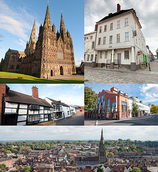
Lichfield is a cathedral city and civil parish in Staffordshire, England. Lichfield is situated 18 miles (29 km) south-east of Stafford, 9 miles (14 km) north-east of Walsall, 8 miles (13 km) north-west of Tamworth and 13 miles (21 km) south-west of Burton Upon Trent. At the time of the 2021 Census, the population was 34,738 and the population of the wider Lichfield District was 106,400.

Mid-Levels is an affluent residential area on Hong Kong Island in Hong Kong. It is located between Victoria Peak and Central. Residents are predominantly more affluent Hong Kong locals and expatriate professionals.

Lichfield District is a local government district in Staffordshire, England. The district is named after its largest settlement, the city of Lichfield, which is where the district council is based. The district also contains the towns of Burntwood and Fazeley, along with numerous villages and surrounding rural areas.

Letocetum is the ancient remains of a Roman settlement. It was an important military staging post and posting station near the junction of Watling Street, the Roman military road to north Wales, and Icknield Street. The site is now within the parish of Wall, Staffordshire, England. It is owned and run by the National Trust, under the name Letocetum Roman Baths Site & Museum. The site is in the guardianship of English Heritage as Wall Roman Site.

Wall is a small village and civil parish in Staffordshire, England, just south of Lichfield. It lies on the site of the Roman settlement of Letocetum.

Beacon Park is a public park in the centre of the city of Lichfield, Staffordshire, in the United Kingdom. The park was created in 1859 when the Museum Gardens were laid out adjacent to the newly built Free Museum and Library. The park has since been extended in stages and now forms 69 acres (28 ha) of open parkland in the city centre. The park is in the northwest of the city centre and to the west of the Cathedral Close across the road from the Garden of Remembrance.

Hobson's Conduit, also called Hobson's Brook, is a watercourse that was built from 1610 to 1614 by Thomas Hobson and others to bring fresh water into the city of Cambridge, England from springs at Nine Wells, a Local Nature Reserve, near the village of Great Shelford. It is now a Scheduled Ancient Monument and historical relic. The watercourse currently runs overground until Cambridge University Botanic Garden and Brookside, where it is at its widest. At the corner of Lensfield Road stands a hexagonal monument to Hobson, which once formed part of the market square fountain, and was moved to this location in 1856, after a fire in the Market. The flow of water runs under Lensfield Road, and subsequently runs along both sides of Trumpington Street in broad gutters towards Peterhouse and St Catharine's College, and also St Andrew's Street. The conduit currently ends at Silver Street.
The Friary School is a mixed secondary school and sixth form located in Lichfield, Staffordshire, England. The school became an arts and sports college in 2006 and despite this status being withdrawn by the DofE in 2010 the subjects remain high-profile in the school and local community.

The Holy Jesus Hospital is a working office in Newcastle upon Tyne, England, in the care of the National Trust. It is a Grade II* listed building.

The Franciscan Friary of Southampton was founded c. 1233. It occupied a south-eastern area of the city, within the walls and adjacent to God's House Tower. The friary was notable for its water supply system, which supplied water for use by the friars themselves and by the other inhabitants of Southampton. The friary was dissolved in 1538 and the last remains were swept away in the 1940s. The site is now occupied by Friary House. Elsewhere, remnants of the extensive water supply system still survive today.

The Church of St Chad is a parish church in the area of Stowe in the north of the city of Lichfield, Staffordshire, in the United Kingdom. It is a Grade II* Listed Building. The church is located to the north of Stowe Pool on St Chad's Road. The current building dates back to the 12th century although extensive restorations and additions have been made in the centuries since.

St Michael on Greenhill is a parish church in Lichfield, Staffordshire in England, located on the high ground of Greenhill in the east of the city. A church has been on the present site since at least 1190 but the current building dates mainly from the restoration of 1842–43. The churchyard is one of five ancient burial grounds in England and is one of the largest churchyards in the country at 9 acres (36,000 m2).

St Mary's Church is a city centre church in Lichfield, Staffordshire in the United Kingdom, located on the south side of the market square. A church is reputed to have been on the present site since at least 1150 but the current building dates from 1870 and is a Grade II* listed building. The church was remodelled in the early 1980s and again in 1997-1999 and now serves a variety of purposes including Lichfield Library and Tourist Information on the ground floor, and on the top floor, The Hub at St Mary's is now home to a speciality coffee shop, art gallery, treasury exhibition and performing arts space.
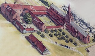
The Franciscan Friary was once a large estate located on the west side of Lichfield city centre in Staffordshire. The estate was built and inhabited by the Franciscan Friars from 1237. At one time the estate consisted of a large church, a cloister, dormitory lodge and a refectory building as well as many other domestic dwellings.
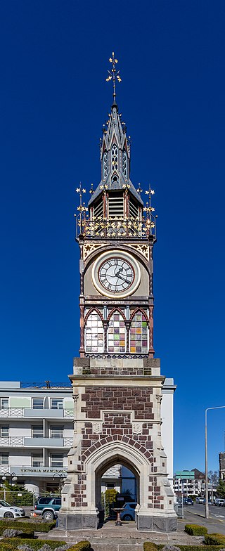
The Victoria Clock Tower, also known as the Diamond Jubilee Clock Tower, is a heritage-registered clock tower located in Christchurch, New Zealand. Designed by Benjamin Mountfort, it is registered as a "Historic Place – Category I" by the New Zealand Historic Places Trust.

The Guildhall is a historic building in Bore Street in Lichfield, Staffordshire in the United Kingdom. The guildhall is a Grade II listed building.

The Paddington Town Hall is a heritage-listed former town hall building located at 249 Oxford Street in the inner eastern Sydney suburb of Paddington, in the City of Sydney local government area of New South Wales, Australia. Sir Henry Parkes laid its foundation stone in 1890 when Paddington was a separate municipality. It was designed by John Edward Kemp and built from 1890 to 1891, and remains a distinctive example of Victorian architecture in Sydney. The clock tower, completed in 1905, is 32 metres (105 ft) high and is a prominent landmark on the ridge of Oxford Street. It is also known as Town Hall and was added to the New South Wales State Heritage Register on 2 April 1999.

Gladstone Post Office is a heritage-listed former post office at 33 Goondoon Street, Gladstone, Gladstone Region, Queensland, Australia. It was built in 1932 by relief workers. It was added to the Queensland Heritage Register on 7 May 1998.
Mary Immaculate Church is a heritage-listed Roman Catholic church and friary at 45 Victoria Street, Waverley, in the Waverley Municipality of Sydney, New South Wales, Australia. It was designed by Sheerin & Hennessy and built from 1890 to 1929 by John Ptolomy and by W. J. Bolton (1929). It is also known as Mary Immaculate Group, St Charles Borromeo Church and Parish House and Minamurra Cottage (former). The property is owned by the Association of Franciscan Friars Bros. It was added to the New South Wales State Heritage Register on 2 April 1999.
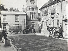
 Bore Street c.1900
 St John's Street c.1900
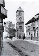 Bore Street c.1920s
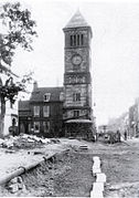 'The Friary' during construction 1928


