
Staffordshire is a landlocked ceremonial county in the West Midlands region of England. It borders Cheshire to the northwest, Derbyshire and Leicestershire to the east, Warwickshire to the southeast, the West Midlands and Worcestershire to the south, and Shropshire to the west. The largest settlement is the city of Stoke-on-Trent, and the county town is Stafford.
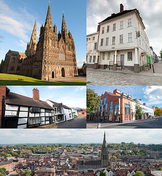
Lichfield is a cathedral city and civil parish in Staffordshire, England. Lichfield is situated 18 miles (29 km) south-east of Stafford, 9 miles (14 km) north-east of Walsall, 8 miles (13 km) north-west of Tamworth and 13 miles (21 km) south-west of Burton Upon Trent. At the time of the 2021 Census, the population was 34,738 and the population of the wider Lichfield District was 106,400.

Cannock Chase, often referred to locally as The Chase, is a mixed area of countryside in the county of Staffordshire, England. The area has been designated as the Cannock Chase Area of Outstanding Natural Beauty and is managed by Forestry England. The Chase gives its name to the Cannock Chase local government district. It is a former Royal forest.

East Staffordshire is a local government district with borough status in Staffordshire, England. Its two main towns are Burton upon Trent and Uttoxeter.

South Derbyshire is a local government district in Derbyshire, England. The council is based in the town of Swadlincote. The district also contains numerous villages and surrounding rural areas. About a third of the National Forest lies within the district.

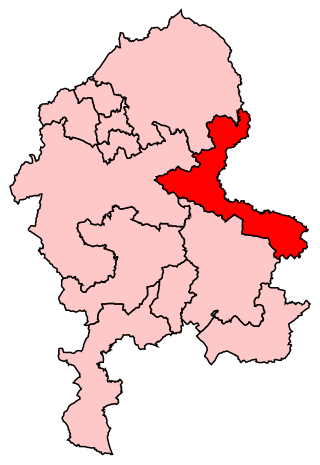
Lichfield District is a local government district in Staffordshire, England. The district is named after its largest settlement, the city of Lichfield, which is where the district council is based. The district also contains the towns of Burntwood and Fazeley, along with numerous villages and surrounding rural areas.

The Metropolitan Borough of Solihull is a metropolitan borough in West Midlands county, England. It is named after its largest town, Solihull, from which Solihull Metropolitan Borough Council is based. For Eurostat purposes it is a NUTS 3 region and is one of seven boroughs or unitary districts that comprise the "West Midlands" NUTS 2 region. Much of the large residential population in the north of the borough centres on the communities of Castle Bromwich, Kingshurst, Marston Green and Smith's Wood as well as the towns of Chelmsley Wood and Fordbridge. In the south are the towns of Shirley and Solihull, as well as the large villages of Knowle, Dorridge, Meriden and Balsall Common.

The Diocese of Lichfield is a Church of England diocese in the Province of Canterbury, England. The bishop's seat is located in the Cathedral Church of the Blessed Virgin Mary and Saint Chad in the city of Lichfield. The diocese covers 4,516 km2 (1,744 sq mi) of several counties: almost all of Staffordshire, northern Shropshire, a significant portion of the West Midlands, and very small portions of Warwickshire and Powys (Wales).
Burton is a constituency represented in the House of Commons of the Parliament of the United Kingdom. It elects one Member of Parliament (MP) by the first past the post system of election.

Lichfield is a constituency in Staffordshire represented in the House of Commons of the UK Parliament since its 1997 recreation by Michael Fabricant, a Conservative.

The A5127 is a major road in England which runs between Birmingham and Lichfield, Staffordshire. For much of the route the road follows the old route of the A38 which has since been moved in order to by-pass places such as Erdington and Sutton Coldfield and form a relief road from Birmingham city centre to Spaghetti Junction.
Lichfield District Council elections are held every four years. Lichfield District Council is the local authority for the non-metropolitan district of Lichfield in Staffordshire, England. Since the last boundary changes in 2015, 47 councillors have been elected from 22 wards.
Tamworth was a rural district in the English Midlands from 1894 to 1965.

Blake Street railway station serves the Hill Hook area of Sutton Coldfield, Birmingham, England. It is situated on the Cross-City Line, located on the county boundary between the West Midlands and Staffordshire. The station is managed by West Midlands Trains, who operate all trains serving it.

Ellenhall is a small Staffordshire village roughly 2.5 miles south of Eccleshall originally comprising part of the extensive estates of the Earl of Lichfield. The population as taken at the 2011 census was 144. The village consists of a scattered community of cottages, a hall, and several farms. Ellenhall has no shop, public house or post office.
South Staffordshire College is a further education college located over four sites in Staffordshire, England.

The Mercian Trail is the name given to a group of museums and historical sites in the West Midlands of England that will be used to display objects from the Staffordshire Hoard. The trail is organised by a partnership of Lichfield District, Tamworth Borough Council, Staffordshire County Council, Stoke-on-Trent City Council and Birmingham City Council, and features the following locations:
Lichfield Road is a cricket ground in Stone, Staffordshire. The ground was established in 1948, when Staffordshire played Buckinghamshire in the grounds first Minor Counties Championship match. From 1948 to the present day, it has hosted 43 Minor Counties Championship matches.

Staffordshire Record Office is the county record office for Staffordshire, England. It is run by Staffordshire County Council, and is located in Eastgate Street, Stafford, behind the William Salt Library. Some records are held at the service's offsite store also in Stafford.

Offlow is a hundred in the county of Staffordshire, England, located in the south-east of that county. It is named after a tumulus or mound in the parish of Swinfen and Packington, 2+1⁄2 miles south of Lichfield. The hundred is recorded in the Domesday Book under the name "Offelav".
