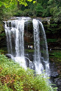
The Cullasaja River is a short river located entirely in Macon County, North Carolina. It is a tributary of the Little Tennessee River, into which it flows near the county seat of Franklin. It originates to the southeast, near Highlands, the county's only other town. It flows from manmade Lake Sequoyah, which is fed by Mirror Lake and other creeks and streams originating on the western side of the Eastern Continental Divide, which runs through the east side of Highlands.
Ellerbe Creek is tributary of the Neuse River in North Carolina, USA. It is part of the Neuse River Basin, and flows for more than twenty miles through North Durham. The Ellerbe's watershed begins near Orange County north of Interstate 85, near the WDNC radio tower and Bennett Place. The creek flows through many of Durham's most historic and culturally significant areas, including Ninth Street, Downtown Durham, beneath Durham Athletic Park, The North Carolina School of Science and Mathematics, the Museum of Life and Science, the old Durham Landfill, Duke University East Campus, Trinity Park, Walltown, Northgate Mall, and towards the end crosses Fishdam Road. The Ellerbe eventually flows into Falls Lake, about a mile south of the Eno River.
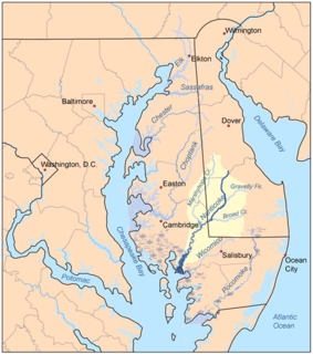
Marshyhope Creek is a 37.0-mile-long (59.5 km) tributary of the Nanticoke River on the Delmarva Peninsula. It rises in Kent County, Delaware, and runs through Caroline County, Maryland, and Dorchester County, Maryland.

The Ararat River is a tributary of the Yadkin River in southwestern Virginia and northwestern North Carolina in the United States. Via the Yadkin it is part of the watershed of the Pee Dee River, which flows to the Atlantic Ocean.
Coddle Creek is a stream/river that rises near Mooresville in Iredell County, North Carolina. It flows through most of northwestern Cabarrus County, North Carolina where it empties into Rocky River near Harrisburg, North Carolina.

Great Alamance Creek, also called Big Alamance Creek, is a 37-mile long creek that is a tributary of the Haw River. The creek's headwaters are in Guilford County, but it flows primarily through Alamance County, North Carolina. It is a major source of water for the cities of Burlington and Greensboro through the Lake Mackintosh Reservoir. It was called "Alamance" after an old local Native American word used to describe the blue-colored mud in the bottom of the creek.
Broad Creek is a water body bordering the community of Broad Creek, North Carolina. The creek empties into Bogue Sound, which is separated from the Atlantic Ocean by Bogue Banks, part of North Carolina's barrier islands known as the Southern Outer Banks. The creek also runs through the Croatan National Forest.

Abbotts Creek starts in Kernersville, NC in Forsyth County and becomes High Rock Lake near Lexington, NC in Davidson County just north of Hwy 47. The section of High Rock Lake that is officially Abbotts Creeks ends near the Hwy 8 causeway, in Southmont, NC.
Brasstown Creek is a stream in the U.S. states of Georgia and North Carolina. The 8.5-mile (13.7 km) long stream is a tributary to the Hiwassee River.

Coal Lick Run is a small tributary to South Fork Tenmile Creek in southwestern Pennsylvania. The stream rises in northeastern Greene and flows north entering South Fork Tenmile Creek east of Morrisville, Pennsylvania near the Greene County Airport. The watershed is roughly 30% agricultural, 53% forested and the rest is other uses.
Browns Run is a small tributary to South Fork Tenmile Creek in southwestern Pennsylvania. The stream rises in northeastern Greene County and flows south-southeast entering South Fork Tenmile Creek at Mather, Pennsylvania. The watershed is roughly 31% agricultural, 61% forested and the rest is other uses.
Ruff Creek is a large tributary to South Fork Tenmile Creek in southwestern Pennsylvania. The stream rises in north-central Greene County and flows southeast entering South Fork Tenmile Creek northeast of Morrisville, Pennsylvania. The watershed is roughly 27% agricultural, 64% forested and the rest is other uses.
Brown Creek is a tributary of the Pee Dee River in south-central North Carolina and north-central South Carolina that drains Chesterfield County, South Carolina, Union County, North Carolina, and Anson County, North Carolina.
Black Jack Branch is a tributary of Brown Creek in south-central North Carolina that drains Union County, North Carolina and Anson County, North Carolina.
Rushing Branch is a tributary of Brown Creek in Anson County, North Carolina that rises near Becky Hill, then flows northwest follows to Brown Creek near White Store, North Carolina. The watershed is about 83% forested, 12% agricultural and the rest is of other land uses.
Kelly Branch is a tributary of Brown Creek in Anson County, North Carolina that rises just south of Peachland, North Carolina and then flows south to meet Brown Creek. The watershed is about 55% forested, 41% agricultural and the rest is of other land uses.
Swans Branch is a tributary of Brown Creek in Anson County, North Carolina that rises in the town of Peachland, North Carolinaand then flows east to meet Brown Creek south of Polkton, North Carolina. The watershed is about 57% forested, 35% agricultural and the rest is of other land uses.
Ledbetter Branch is a tributary of Brown Creek in Anson County, North Carolina that rises north of Polkton, North Carolina and then flows south to meet Brown Creek south of Polkton, North Carolina. The watershed is about 48% forested, 34% agricultural and the rest is of other land uses.
Pinch Gut Creek is a tributary of Brown Creek in Anson County, North Carolina that rises southeast of Polkton, North Carolina and then flows south to meet Brown Creek east of Polkton. The watershed is about 70% forested, 23% agricultural and the rest is of other land uses.
Cranes Branch is a tributary of Brown Creek in Anson County, North Carolina that rises north of Polkton, North Carolina and then flows east to meet Brown Creek about 3 miles northeast of Polkton. The watershed is about 58% forested, 36% agricultural and the rest is of other land uses.


