A longhouse or long house is a type of long, proportionately narrow, single-room building for communal dwelling. It has been built in various parts of the world including Asia, Europe, and North America.

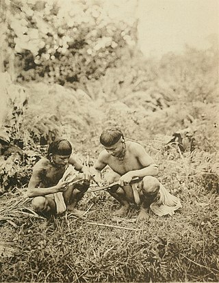
Being an indigenous tribe in Borneo, the Kayan people are similar to their neighbours, the Kenyah tribe, with which they are grouped together with the Bahau people under the Apo Kayan people group. The Kayan people are categorised as a part of the Dayak people. They are distinct from, and not to be confused with, the Kayan people of Myanmar.

The Rajang River is a river in Sarawak, northwestern Borneo, Malaysia. The river originates in the Iran Mountains, flows through Kapit, and then towards the South China Sea. At approximately 565 km long (351 mi), the river is the seventh-longest in Borneo and the longest in Malaysia.
Punan Bah or Punan is an ethnic group found in Sarawak, Malaysia and in Kalimantan, Indonesia. The Punan Bah people are distinct and unrelated to the semi-nomadic Penan people. Their name stems from two rivers along the banks of which they have been living since time immemorial. They have other names including Mikuang Bungulan or Mikuang and Aveang Buan but those are used only ritually nowadays.

Marudi is a town in the Malaysian state of Sarawak, and is a part of the division of Miri. It is the seat of Marudi District, and is located on the banks of Baram River, about 100 kilometres (62 mi) upstream from the river mouth. Marudi was the administrative centre of the northern region of Sarawak before Miri was established in 1910. Marudi is considered as the cultural heart of the Orang Ulu, the highland tribes of Sarawak. It is also a transit gateway to Kelabit Highlands and Gunung Mulu National Park, a UNESCO World Heritage Site.
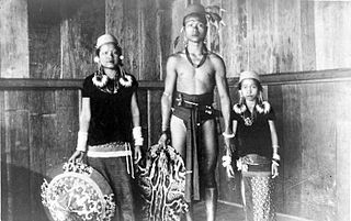
The Kenyah people are an indigenous, Austronesian-speaking people of Borneo, living in interior North and East Kalimantan, Indonesia and Sarawak, Malaysia.
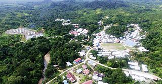
Long Moh is a longhouse settlement in the Marudi division of Sarawak, Malaysia. It lies approximately 551.6 kilometres (343 mi) east-north-east of the state capital Kuching.
Long Anap is a longhouse and settlement in the Telang Usan district of Sarawak, Malaysia. It lies approximately 525.2 kilometres (326 mi) east-north-east of the state capital Kuching, in the upper reaches of the Baram River.
Long Selatong is a Kenyah longhouse in the Marudi division of Sarawak, Malaysia. It lies approximately 531.2 kilometres (330 mi) east-north-east of the state capital Kuching.
Long Julan is a Kenyah longhouse in the interior of the Miri division of Sarawak, Malaysia. It lies approximately 524.6 kilometres (326 mi) east-northeast of the state capital Kuching.
Lio Matoh is a remote Kenyah Badeng longhouse settlement in the mountainous interior of the Marudi division of Sarawak, Malaysia, not far from the border with Indonesia. It lies approximately 572.6 kilometres (356 mi) east-north-east of the state capital Kuching.
Long Laput is a settlement in the rural interior of the Marudi district of Sarawak, Malaysia. It lies approximately 514.3 kilometres (320 mi) east-north-east of the state capital Kuching.
Long Selaan is a settlement in Sarawak, Malaysia. It lies approximately 553.9 kilometres (344 mi) east-north-east of the state capital Kuching.
Sarawak's population is very diverse, comprising many races and ethnic groups. Sarawak has more than 40 sub-ethnic groups, each with its own distinct language, culture and lifestyle. This makes Sarawak demography very distinct and unique compared to its Peninsular counterpart. However, it largely mirrors to other territories in Borneo – Sabah, Brunei and Kalimantan.
Mainstream Kenyah, also known as Usun Apau and Bakung, is a Kenyah dialect cluster of North Kalimantan, Indonesia, and Sarawak, Malaysia. Dialects fall into four clusters:
Data Kakus is a remote Kenyah Badeng village settlement in the hilly interior of the Ulu Kakus Tatau division of Sarawak, Malaysia elevates to 650 metres, not far from Tubau and Belaga district. To be exact, Data Kakus is located at the upstream of Sungai Burok and Sungai Nyabet. The highest peak in Ulu Kakus is called Gunung Lumut about 828m located on the peak of Lumut Range not too far from Sungai Bekuyat and Sungai Kakus.

Guy Arnold was a British explorer, travel writer, political writer and specialist in north-south relations, who wrote mainly in the areas of African history, politics, and international affairs. He was based in Marylebone, London.
Usun Apau Plieran is a remote abandoned Kenyah Jamuk, Badeng and Lepu Aga' village settled in 1860, Belaga district. To be exact, Usun Apau Plieran is located at the upstream of Sungai Plieran and Sungai Tiyut. The highest peak that close to this area are Bukit Busing 1300m and Mudung Batu Bora about 1450m. There are a few old longhouse sites in this area such as Long Metalon, Long Ampan Aing, Long Bora, Long Taa, Ka Laeh, Lidung Jelo and Lolau Mabo.
The Klemantan people were a purported ethnic group indigenous to the island of Borneo. The term was established in Western literature by British scientist and colonial administrator Charles Hose in the early 20th century, but has since been rejected as an invented term of convenience that does not properly represent the people it claims to describe. Since then, the term has fallen largely out of use.
Usun Apau National Park is a national park in Sarawak, Malaysia, on the island of Borneo. It was designated in 2005. It covers the Usun Apau Plateau in the highlands of central Borneo.