
Rotterdam is the second-largest city in the Netherlands after the national capital of Amsterdam. It is in the province of South Holland, part of the North Sea mouth of the Rhine–Meuse–Scheldt delta, via the "New Meuse" inland shipping channel, dug to connect to the Meuse at first and now to the Rhine.

Alphen aan den Rijn is a city and municipality in the western Netherlands, in the province of South Holland. The city is situated on the banks of the river Oude Rijn, where the river Gouwe branches off. The municipality had a population of 112,587 in 2021, and covers an area of 132.50 km2 (51.16 sq mi) of which 6.27 km2 (2.42 sq mi) is water.

Pedestrian zones are areas of a city or town restricted to use by people on foot or human-powered transport such as bicycles, with non-emergency motor traffic not allowed. Converting a street or an area to pedestrian-only use is called pedestrianisation.
The year 1953 in architecture involved some significant events.

Henri "Hans" van den Broek is a retired Dutch politician and diplomat of the defunct Catholic People's Party (KVP) and later the Christian Democratic Appeal (CDA) party and jurist who served as European Commissioner from 6 January 1993 until 16 September 1999.

Strøget is a pedestrian, car-free shopping area in Copenhagen, Denmark. This popular tourist attraction in the centre of town is one of the longest pedestrian shopping streets in Europe at 1.1 km. Located at the centre of the old city of Copenhagen, it has long been one of the most high-profile streets in the city.
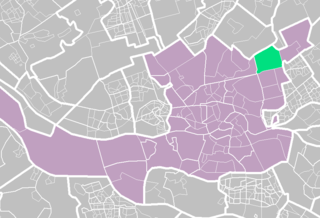
Ommoord is a neighbourhood in the former borough Prins Alexander, part of the municipality of Rotterdam, South Holland, the Netherlands. Ommoord is surrounded by the neighbourhoods Zevenkamp, Het Lage Land and Terbregge. It has around 25,000 inhabitants across 12,500 households. Ommoord shares postal codes 3068 and 3069 with Zevenkamp.

Johannes Hendrik "Jo" van den Broek was a Dutch architect influential in the rebuilding of Rotterdam after World War II.

Jacob Berend "Jaap" Bakema was a Dutch modernist architect, notable for design of public housing and involvement in the reconstruction of Rotterdam after the Second World War.

The Poortgebouw is a national monument located at Stieltjesstraat 38 in the Kop van Zuid area of Rotterdam, the Netherlands. It was built beside the River Maas in 1879 and experienced a range of uses until it was squatted 3 October 1980. It had been standing empty for 2 years and was squatted as a protest intended to highlight the lack of affordable residential housing in Rotterdam.

Leendert Cornelis van der Vlugt was a Dutch architect in Rotterdam. In the architects office Brinkman & Van der Vlugt he was responsible for the architecture of the Van Nelle Factory, a listed monument of the UNESCO World Heritage Site since 2014.

The former Van Nelle Factory on the Schie in Rotterdam, is considered a prime example of the modernist and functionalist architecture. It has been a designated UNESCO World Heritage Site since 2014. Soon after it was built, prominent architects described the factory as "the most beautiful spectacle of the modern age" and "a poem in steel and glass".

The Berg en Broeksche Verlaat is a canal lock in Rotterdam between the River Rotte and 2 peat bogs. It was built in 1866 and has Rijksmonument status.

Blijdorp is a neighbourhood in northern Rotterdam and is part of the borough Noord. The neighbourhood has around 9500 inhabitants.

Cool is a neighborhood of Rotterdam, Netherlands in the Centrum borough. It is enclosed by the Weena in the north, the Mauritsweg and Eendrachtsweg in the west, Vasteland in the south and the Coolsingel and Schiedamse Vest in the east.

Nieuwe Westen is a pre-war neighbourhood in the west of Rotterdam, located between the Heemraadssingel and the Delfshavense Schie in the Delfshaven district.
Coolsingel is a street in central Rotterdam. It is located in the Cool district. The street leads from the Hofplein to the Churchillplein. Plans were announced in 2016 to reduce traffic congestion on the street. The redevelopment is expected to cost 47 million euros and to be finished by 2020. In 2021 the renovation was finished giving cyclists and pedestrians more space. Car traffic was reduced from 4 lanes to 2 lanes.
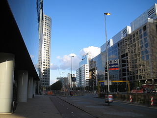
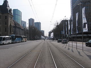
Weena is a street with many highrises in the center of Rotterdam, Netherlands. It defines the Rotterdam skyline. The street of about 1 kilometer length leads east-west from Hofplein to Beukelsdijk.

Johannes Andreas Brinkman, also known as Jan Brinkman, was a Dutch architect and exponent of Nieuwe Bouwen, modern architecture in the Netherlands.

Michiel Brinkman (1873–1925) was a Dutch architect and the father of Johannes Brinkman the exponent of Nieuwe Bouwen, modern architecture in the Netherlands. Michiel Brinkman is notable for his Justus van Effen housing block complex in Spangen, which is a Rijksmonument, built in 1922. it incorporates 3m wide connecting terraces on the third floor, known in Dutch as Bovenstraten, and in English as 'Streets in the sky'.

