
The Bagmati River flows through the Kathmandu valley of Nepal, separating the cities of Kathmandu and Patan, before flowing through Madesh Province of southern Nepal and joining the Kamla River in the Indian state of Bihar. It is considered holy by both Hindus and Buddhists. A number of Hindu temples are located on its banks.

Dudh Koshi is a river in eastern Nepal. It is the highest river in terms of elevation.

Teesta River is a 414 km (257 mi) long river that rises in the Pauhunri Mountain of eastern Himalayas, flows through the Indian states of Sikkim and West Bengal and subsequently enters Bangladesh through Rangpur division. In Bangladesh, it falls into Brahmaputra River which after meeting some other major rivers of the Bengal delta finally falls into the Bay of Bengal. It drains an area of 12,540 km2 (4,840 sq mi). In India, the Teesta flows through Mangan District, Gangtok District, Pakyong District, Kalimpong district, Darjeeling District, Jalpaiguri District, Cooch Behar districts and the cities of Rangpo, Jalpaiguri and Mekhliganj. In Bangladesh, it flows through Lalmonirhat District, Rangpur District, Kurigram District and Gaibandha District. It joins the Brahmaputra River at Phulchhari Upazila in Bangladesh. 305 km (190 mi) of the river lies in India and 109 km (68 mi) in Bangladesh. Teesta is the largest river of Sikkim and second largest river of West Bengal after the Ganges.

The Gandaki River, also known as the Narayani and Gandak, is one of the major rivers in Nepal and a left-bank tributary of the Ganges in India. Its total catchment area amounts to 46,300 km2 (17,900 sq mi), most of it in Nepal. In the Nepal Himalayas, the Gandaki is notable for its deep canyon. The basin also contains three mountains over 8,000 m (26,000 ft), namely Dhaulagiri, Manaslu and Annapurna Massif. Dhaulagiri is the highest point of the Gandaki basin.

The Sunuwar or Koinch are a Tibeto-Burman ethnic group. a Kirati tribe native to Nepal, parts of India and southern Bhutan. They speak the Sunuwar language. According to the 2001 census of Nepal, 17% of the tribe follow the Kirant religion and adopt the Mundhum (Kiranti) culture.
Sarlahi, a part of Madhesh Province, is one of the seventy-seven districts of Nepal. According to new laws, a combination of more than two or four villages makes a municipality, which covers an area of 1,259 km2 (486 sq mi) and had a population of 635,701 in 2001 and 769,729 in 2011.

Udayapur District (Nepali: उदयपुर जिल्ला, is one of the fourteen districts of Koshi Province in Eastern Nepal. The district, with Triyuga as its district headquarters, covers an area of 2,063 km2 and in 2001 had a population of 287,689, in 2011 of 317,532, in 2021 of 342,773

The Jaldhaka River (Pron:/ˌdʒælˈdɑːkə/), also known as Dichu, a tributary of Brahmaputra is a trans-boundary river flowing through India, Bhutan and Bangladesh with a length of 233 kilometres. It originates from the Bitang Lake at Kupup, Gangtok District, Sikkim, near the Jelep La pass below Dongkya Mountain Range. It flows through Pakyong District of Sikkim, India and then passes through forests of Samtse District of Bhutan where it flows for around 40 kilometres and than re-enters India at Bindu, Kalimpong district. Further it passes through Neora Valley National Park, Chapramari Wildlife Sanctuary & Gorumara National Park in West Bengal along with cities and towns like,Paren, Gairibas, Jhalong, Dhupguri, Falakata, Mathabhanga and flows through Kalimpong, Jalpaiguri and Cooch Behar districts in West Bengal, India before the river enters Bangladesh at Mogolhat, Lalmonirhat District of Rangpur Division. It is known as Dharla River in Bangladesh and flows through towns like Kolaghat, Phulbari and Kurigram City and Passes southwards until the Dharla debouches into the Brahmaputra River at Bagua Anantpur of Kurigram District. Due to the river's wandering over several international borders, only a small length of the river lies in Bangladesh and Bhutan and most of its path lies in India. In some places, this river is also known as Mansai river and Singhimari river.

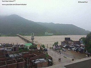
The Kosi or Koshi is a transboundary river which flows through China, Nepal and India. It drains the northern slopes of the Himalayas in Tibet and the southern slopes in Nepal. From a major confluence of tributaries north of the Chatra Gorge onwards, the Kosi River is also known as the Saptakoshi for its seven upper tributaries. These include the Tamur River originating from the Kanchenjunga area in the east and Arun River and the Sun Kosi from Tibet. The Sun Koshi's tributaries from east to west are the Dudh Koshi, Likhu Khola, Tamakoshi River, Bhote Koshi and Indravati. The Saptakoshi crosses into northern Bihar, India where it branches into distributaries before joining the Ganges near Kursela in Katihar district. The Kosi is the third-largest tributary of the Ganges by water discharge after the Ghaghara and the Yamuna.

River Rangpo is a river in the Indian state of Sikkim. A tributary of the Teesta River, it originates from Menmecho Lake near Dzuluk and flows through Rongli and Pakyong subdivision villages in Pakyong District towards Rorathang, Kumrek and Rangpo. The river demarcates the border between Pakyong District of Sikkim and Kalimpong district of West Bengal from Rorathang to Rangpo. At the town of Rangpo the river joins river Teesta. River Rangpo is the third largest river of Sikkim after Teesta and Rangeet. Atal Setu Bridge the longest roadway bridge of sikkim lies over River Rangpo.

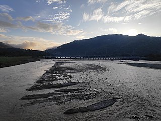
Bhimeshwar,, is a municipality in north-eastern Nepal and the headquarters of Dolakha District in Bagmati Province that was established in 1997 by merging the former Village development committees Charikot, Dolakha Town, Makaibari and Mati. At the time of the 2011 Nepal census, it had a population of 32,486 people living in 8,639 individual households. The town is located at an altitude of 1,554 metres (5,101 feet). The name of the district Dolakha came from Dolakha Town situated north-east of the headquarters Charikot Bazaar.

The Trishuli River is one of the major tributaries of the Narayani River basin in central Nepal. The river is formed by the merger of Kyirong Tsangpo and Lende Khola originating in Gyirong County of Tibet, which join together near the Rasuwa Gadhi on the Nepal–Tibet border. The valley of the river used to be the traditional trade route between the Kathmandu Valley and Tibet.

The Sunkoshi, also spelt Sunkosi, is a river that is part of the Koshi or Saptkoshi River system in Nepal. Sunkoshi has two source streams, one that arises within Nepal in Choukati, and the other more significant stream that flows in from Nyalam County in the Tibet region of China. The latter is called Bhote Koshi in Nepal and Matsang Tsangpo in Tibet. Due to the significant flows from Bhote Koshi, the Sun Koshi river basin is often regarded as a trans-border river basin.
West Rapti, also known as the Kuwano, is a river which drains Rapti Zone in Mid-Western Region, Nepal, then Awadh and Purvanchal regions of Uttar Pradesh state, and finally India before joining the Ghaghara. It is a major left bank tributary of the Ganges, and is also known as the Karnali inside Nepal.
Tashicholing or Sipsu Gewog is a gewog of the Samtse District, Bhutan.

The Babai River originates in and completely drains Inner Terai Dang Valley of Mid-Western Nepal. Dang is an oval valley between the Mahabharat Range and Siwalik Hills in its eponymous district. Dang was anciently home to indigenous Tharu people and came to be ruled from India by the House of Tulsipur who also counted as one of the Baise Rajya —a confederation of 22 petty kingdoms in the Karnali (Ghagra) region. About 1760 AD all these kingdoms were annexed by the Shah Dynasty during the unification of Nepal, except Tulsipur lands south of the Siwalik Hills were not taken. Since Dang Valley was somewhat higher, cooler, better-drained and therefore less malarial than most of the country's Inner Terai, it was settled to some extent by Shah and Rana courtiers and other Paharis long before DDT was introduced to control the disease-bearing Anopheles mosquito.

The Kirat Region is an area of the Eastern Himalayas which is inhabited by ethnic Kirati people. in the History of Nepal earliest inhabitants of Nepal are Kiratis of Eastern hills.Kirati states divided into three subdivision "Wallo Kirat” or Near Kirat is from east of Kathmandu Valley to Likhu Khola, "Majh Kirat” or Middle Kirat is east of Likhu River to Upper Arun Valley and the "Pallo Kirat” or Far Kirat is east of Arun valley Sabha River to Singalila Ridge along the border of Sikkim and Darjeeling.

The Champabati River is a tributary of the Brahmaputra River in the Indian state of Assam. The Champabati River has three sub tributaries - Bhur River, Lopani and Dhol pani which are originated from Bhutan hills.

