The Elbe is one of the major rivers of Central Europe. It rises in the Giant Mountains of the northern Czech Republic before traversing much of Bohemia, then Germany and flowing into the North Sea at Cuxhaven, 110 kilometres northwest of Hamburg. Its total length is 1,094 km (680 mi).

The Ore Mountains lie along the Czech–German border, separating the historical regions of Bohemia in the Czech Republic and Saxony in Germany. The highest peaks are the Klínovec in the Czech Republic at 1,244 metres (4,081 ft) above sea level and the Fichtelberg in Germany at 1,215 metres (3,986 ft).
The Sächsische Schweiz is a former district (Kreis) in the south of Saxony, Germany. Neighboring districts were Weißeritzkreis, the district-free city Dresden and the districts Kamenz and Bautzen. To the south it borders the Czech Republic.

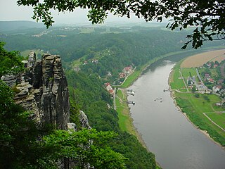
Saxon Switzerland is a hilly climbing area and national park in the Elbe Sandstone Mountains, located around the Elbe valley south-east of Dresden in Saxony, Germany. Together with Bohemian Switzerland in the Czech Republic, the region is known as Saxon-Bohemian Switzerland.

The Elbe Sandstone Mountains, also called the Elbe Sandstone Highlands, are a mountain range straddling the border between the state of Saxony in southeastern Germany and the North Bohemian region of the Czech Republic, with about three-quarters of the area lying on the German side. In both countries, core parts of the mountain range have been declared a national park. The name derives from the sandstone which was carved by erosion. The river Elbe breaks through the mountain range in a steep and narrow valley.
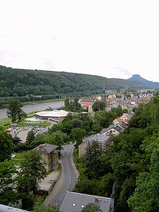
Bad Schandau is a spa town in Germany, in the Sächsische Schweiz-Osterzgebirge district of Saxony. It is situated on the right bank of the Elbe, at the mouth of the valley of the Kirnitzsch and in the area often described as Saxon Switzerland.

The Biela or Bělá or Ostrovská Bělá is a river in eastern Germany and northern Czech Republic, a left tributary of the Elbe. The source is near Ostrov hamlet in the municipality of Tisá, in the Bohemian Switzerland, northwest of Děčín. After a few km it crosses into Saxony. The town Königstein is located at the confluence of the Biela with the Elbe.
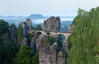
The Bastei is a rock formation rising 194 metres (636 ft) above the Elbe River in the Elbe Sandstone Mountains of Germany. Reaching a height of 305 metres (1,001 ft) above sea level, the jagged rocks of the Bastei were formed by water erosion over one million years ago. They are situated near Rathen, not far from Pirna southeast of the city of Dresden, and are the major landmark of the Saxon Switzerland National Park. They are also part of a climbing and hiking area that extends over the borders into the Bohemian Switzerland.

Bohemian Switzerland, also known as Czech Switzerland, is a nature region in the Elbe Sandstone Mountains in the northwestern Czech Republic, protected as a national park.

The Elbe Cycle Route is part of an international network of cycling routes all over Europe. It is integrated in the system of currently 37 river cycling routes in Germany and by far the most popular route for cyclists in this country.

Stadt Wehlen is a town in the Sächsische Schweiz-Osterzgebirge district, in Saxony, Germany. It is situated on the western edge of Saxon Switzerland, on the right bank of the Elbe, 6 km east of Pirna, and 23 km southeast of Dresden (centre).
Saxon Switzerland National Park, is a national park in the German Free State of Saxony, near the Saxon capital Dresden. It covers two areas of 93.5 km2 (36.1 mi2) in the heart of the German part of the Elbe Sandstone Mountains, which is often called (the) Saxon Switzerland.
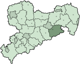
Saxon Switzerland-Eastern Ore Mountains is a district (Kreis) in Saxony, Germany. It is named after the mountain ranges Saxon Switzerland and Eastern Ore Mountains.
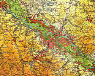
The Dresden Basin is a roughly 45 km long and 10 km wide area of the Elbe Valley between the towns of Pirna and Meißen. The city of Dresden lies in the Dresden Basin.

The Zirkelstein is the smallest table hill of Saxon Switzerland, in Germany. It is a wooded, cone-shaped hill with a striking 40-metre-high (130 ft) summit block of sandstone rock.

The Großer Zschirnstein is the highest hill in the Saxon and German part of the Elbe Sandstone Mountains.

The Saxon Elbeland is a term used in more recent times which describes a region along the Elbe, whose boundaries are not clearly defined, but which extends roughly from the Elbe Sandstone Mountains to Torgau. The best-known cities and town in this area are Dresden, Meißen, Riesa and Torgau. The term is largely synonymous with the region along the river known as the Upper Elbe (Oberelbe), i.e. the German section of the Elbe River nearest its source region.
The Bergtest near Wehlen is a traditional sporting event that has taken place annually since 1980, usually on the last Saturday in March, in the East German hills of Saxon Switzerland.

The Rauenstein is a table hill in Saxon Switzerland in Germany. It rises west of the Elbe inside the Elbe loop near Rathen. It has a height of 304 metres and drops steeply to the north into the Elbe valley. It has a deeply incised structure and is about 600 metres long and 200 metres wide. It thus rises almost 100 metres over the surrounding area. The Rauenstein is almost completely wooded, but has several dominant sandstone rock faces. The sandstone here is very soft and heavily weathered.
The Zschirnsteine are two prominent table hills in the German part of the Elbe Sandstone Mountains. They are located in the municipality of Reinhardtsdorf-Schöna, about 7 km south of the German resort of Bad Schandau. They lie west of the River Elbe and not far north of the Czech border.