Samarkand, alternatively Samarqand, is a city in modern-day Uzbekistan, and is one of the oldest continuously inhabited cities in Central Asia. There is evidence of human activity in the area of the city from the late Paleolithic era, though there is no direct evidence of when Samarkand was founded; some theories propose that it was founded between the 8th and 7th centuries BC. Prospering from its location on the Silk Road between China and the Mediterranean, at times Samarkand was one of the greatest cities of Central Asia.

Dushanbe is the capital and largest city of Tajikistan. Dushanbe means Monday in the Tajik language, the local language. It was named this way because it grew from a village that originally had a popular market on Mondays. As of 2016, Dushanbe had a population of 802,700.

Uzbek is a Turkic language that is the first official and only declared national language of Uzbekistan. The language of Uzbeks, it is spoken by some 33 million native speakers in Uzbekistan and elsewhere in Central Asia.

European route E 40 is the longest European route, more than 8,000 kilometres long, connecting Calais in France via Belgium, Germany, Poland, Ukraine, Russia, Kazakhstan, Uzbekistan, Turkmenistan, and Kyrgyzstan, with Ridder in Kazakhstan near the border with Russia and China.
Uzbekistan is divided into 12 regions, 1 autonomous republic, and 1 independent city. Names are given below in the Uzbek language, although numerous variations of the transliterations of each name exist. The regions in turn are divided into 160 districts.

Osh is the second largest city in Kyrgyzstan, located in the Fergana Valley in the south of the country and often referred to as the "capital of the south". It is the oldest city in the country, and has served as the administrative center of Osh Region since 1939. The city has an ethnically mixed population of about 281,900 in 2017, comprising Uzbeks, Kyrgyz, Russians, Tajiks, and other smaller ethnic groups. It is about 5 km from the Uzbekistan border.

Termez is a city in the southernmost part of Uzbekistan near the Hairatan border crossing of Afghanistan. It is the hottest point of Uzbekistan. It has a population of 140,404, and is the capital of Surxondaryo Region.

Batken Region is a region (oblast) of Kyrgyzstan. Its capital is Batken. It is bounded on the east by Osh Region, on the south, west and north by Tajikistan, and on the northeast by Uzbekistan. The northern part of the region is part of the flat, agricultural Ferghana Valley. The land rises southward to the mountains on the southern border: the Alay Mountains in the east, and the Turkestan Range in the west.

Osh Region is a region (oblast) of Kyrgyzstan. Its capital is Osh. It is bounded by (clockwise) Jalal-Abad Region, Naryn Region, Xinjiang, China, Tajikistan, Batken Region, and Uzbekistan.

Namangan is a city in eastern Uzbekistan. It is the administrative, economic, and cultural center of Namangan Region. Namangan is located in the northern edge of the Fergana Valley, less than 30 km from the Kyrgyzstan border. The city is served by Namangan Airport.
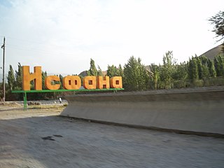
Isfana is a small town in the extreme western end of Batken Region in southern Kyrgyzstan. Isfana is on the southern fringe of the Fergana Valley in a region surrounded on three sides by Tajikistan.

Uzbek cuisine shares the culinary traditions of Turkic peoples across Central Asia. There is a great deal of grain farming in Uzbekistan, so breads and noodles are of importance, and Uzbek cuisine has been characterized as "noodle-rich". Mutton is a popular variety of meat due to the abundance of sheep in the country and it is a part of various Uzbek dishes.

Kaldar is a small district in the northern part of Balkh Province, Afghanistan. The northern and the eastern border of the district is the large Amu Darya river. North of the river is Uzbekistan and east is Tajikistan. The main village, also called Kaldar, is in the northeastern part of the district, close to the river.

Pulgon is a village in the Batken Region of Kyrgyzstan. It is the administrative center of the Kadamjay District. Its population was 2,466 in 2009. In the Soviet era, the village was officially known as Frunzenskoye, and the district was known as Frunzensky District of Osh Region.
Chunkur-Kyshtak is a village in Batken Region of Kyrgyzstan. Its population was 1,851 in 2009.
Ak Tap is a village located on the road from Kunda Gazar to Hazrat Imam. It is about 10 miles from Hazrat Imam, and, as of the turn of the twentieth century, housed 25 Uzbek families.
Khojali, Xocalı, Khodzhali, Khojalu, Khadzhaly, Khodzhaly, Khodzhallar or Khodgalou may refer to:

Uzbek carpet is one of the most well-known handmade carpets produced by Uzbeks. Carpet weaving, being one of the types of Uzbek arts and crafts, is inextricably linked with other kinds of Uzbek arts and crafts, continuing the tradition of other types of national fine art. Originally carpet in Uzbekistan is flourishing in such villages as Kamashi, Hadzhaki and Jeynov in Kashkadarya region.