Related Research Articles

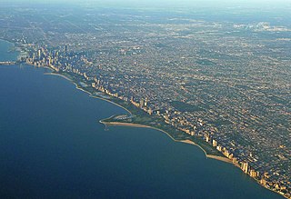
Ojus is a census-designated place and formerly incorporated town in Miami-Dade County, Florida, United States. The population was 16,642 at the 2000 census. Ojus is bordered by Aventura to the east, I-95 to the west, North Miami Beach to the south and Broward County to the north.
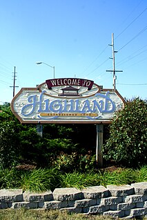
Highland is a town in Lake County, Indiana, United States. The population was 23,727 at the 2010 census. The town was incorporated on April 4, 1910. It is a part of the Chicago metropolitan area and North Township, and is surrounded by Hammond to the north, Munster to the west, Schererville to the south and Griffith to the east.

Lincoln Park is a designated community area on the North Side of Chicago, Illinois. Lying to the west of Lincoln Park, Chicago's largest park, it is one of the most affluent neighborhoods in Chicago.
Lincoln Park is a 1,208-acre (489-hectare) park situated along Lake Michigan on the North Side of Chicago, Illinois. Named after US President Abraham Lincoln, it is the city's largest public park and stretches for seven miles (11 km) from Grand Avenue on the south to near Ardmore Avenue on the north, just north of the Lake Shore Drive terminus at Hollywood Avenue. Several museums and a zoo are located between North Avenue and Diversey Parkway in the eponymous neighborhood. Further to the north, the park is characterized by parkland, beaches, recreational areas, nature reserves, and harbors. To the south, there is a more narrow strip of beaches east of Lake Shore Drive, almost to downtown. With 20 million visitors per year, Lincoln Park is the second-most-visited city park in the United States, behind Central Park.

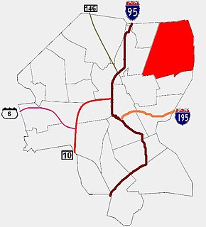
Roads and expressways in Chicago summarizes the main thoroughfares and the numbering system used in Chicago and its surrounding suburbs.

Abraham Lincoln Birthplace National Historical Park is a designated U.S. historic park preserving two separate farm sites in LaRue County, Kentucky, where Abraham Lincoln was born and lived early in his childhood. He was born at the Sinking Spring site south of Hodgenville and remained there until the family moved to the Knob Creek Farm northeast of Hodgenville when he was two years old, living there until he was seven years of age. The park's visitor center is located at the Sinking Spring site.

Oakland is one of five primary historic neighborhoods of the city of Taunton, Massachusetts. Although these neighborhoods are not census-designated areas, they are municipally designated populated regions of the city.

Hillsgrove, originally Hill's Grove, is a village in western central Warwick, Rhode Island.

Navarre is a neighborhood of the city of New Orleans. A subdistrict of the Lakeview District Area, its boundaries as defined by the City Planning Commission are: I-610, Canal Boulevard and Florida Boulevard to the north, Orleans Avenue to the east, City Park Avenue to the south and the Pontchartrain Expressway and Pontchartrain Boulevard to the west.

Western Avenue is a street within the city of Chicago. Western Avenue extends south as a continuous road to the Dixie Highway at Sibley Boulevard in Dixmoor, giving the road a total length of 27.38 miles (44.06 km). Western Avenue, after turning into Asbury Ave, runs out on the north side at Green Bay Road in Evanston and on the south side at Crete-Monee Road in Crete. However, Western Avenue extends intermittently through the Southland to the Will/Kankakee county border in unincorporated Will Township. Within Chicago's grid street system, Western Avenue is 2400 West, three miles west of State Street.
West Columbus, sometimes referred to as westside or the West Side, is a neighborhood in Columbus, Ohio, United States. Unlike other Columbus neighborhoods, it is a broad geographical term used by locals rather than a subdivision or suburb. West Columbus is defined as the entire southwest side of Columbus, bordered on the north by interstates 70 and 670, within Interstate 71 on the east, and on the south and west by the city limits that reach several miles to the outside of the I-270 outerbelt. It covers the ZIP Codes 43223, 43204, 43228, and 43222.
Blackstone is a predominantly residential neighborhood in Providence, Rhode Island. It is in the northeast corner of the city and is bounded to the south and west by Lloyd Avenue and Hope Street respectively. It is one of six neighborhoods comprising the East Side of Providence.
Florence is a neighborhood in Omaha, Nebraska, United States on the city's north end and originally one of the oldest cities in Nebraska. It was incorporated by the Nebraska Territorial Legislature on March 10, 1857. The site of Winter Quarters for Mormon migrants traveling west, it has the oldest cemetery for people of European descent and oldest standing gristmill in Nebraska. Florence was the site of an illegal territorial legislature in 1858. Given the high concentration of National Register of Historic Places in the neighborhood, it is regarded as "the historic front door to Omaha as well as the state."

Chastain Memorial Park is the largest city park in Atlanta, Georgia. It is a 268-acre (1.08 km2) park near the northern edge of the city. Included in the park are jogging paths, playgrounds, tennis courts, a golf course, swimming pool, horse park and amphitheater.
The Perkerson neighborhood is located in Southwest Atlanta, Georgia in NPU-X. The name change was made by request of residents/members of the Perkerson Civic Association (PCA) in order to keep people from confusing the neighborhood with Perkerson Park which is the large park that serves the area.
Coral Way is a neighborhood within Miami, Florida that is defined by Coral Way, a road established by Coral Gables founder George E. Merrick during the 1920s. It is located in Miami-Dade County, Florida.
Gibson Bend of the Missouri River is a meander located in Pottawattamie County, Iowa and Douglas County, Nebraska, located at 41°11′15″N95°55′15″W. The Gibson neighborhood is a community area in Omaha, Nebraska abutting the Gibson Bend.
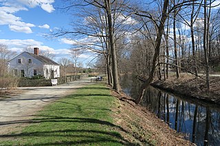
Quinnville is a village incorporated into the Town of Lincoln, Rhode Island. It is the smallest of the seven villages within Lincoln, bordered by the villages of Albion at the north, Limerock to the west, Lonsdale to the south, and by the Blackstone River to the east.
The Hudson County Park System owns and operates several county parks in Hudson County, New Jersey. It has its roots in the City Beautiful movement around the turn of the twentieth century. The system comprises eight parks comprising 716.52 acres (290.0 ha). Additionally, the county owns acreage in preservation areas in the New Jersey Meadowlands
References
- ↑ Engineering Record 24 July 1909: 48
- ↑ "Lincoln Park Cemetery - Chased Schel Amess Association". www.jewishfederations.org. Archived from the original on 15 December 2013. Retrieved 17 January 2022.