
The Serengeti National Park is a national park in Tanzania that stretches over 14,763 km2 (5,700 sq mi). It is located in the Mara and Simiyu regions and contains 15,000,000 hectares of savanna. It is well known for the largest annual animal migration in the world of over 1.5 million blue wildebeest and 250,000 zebra and for its numerous Nile crocodile and honey badger. The park includes the neighbouring Ngorongoro Conservation Area, and Maasai Mara National Reserve in bordering Kenya.
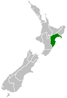
Hawke's Bay Region is a local government region of New Zealand on the east coast of the North Island. The region's name derives from Hawke Bay, which was named by Captain James Cook in honour of Admiral Edward Hawke. The region is governed by Hawke's Bay Regional Council.

Lindi Town is a southern Tanzanian coastal town and regional capital of Lindi Region located at the far end of Lindi Bay, on the Indian Ocean in southeastern Tanzania. The town is 450 kilometres (280 mi) south of Dar es Salaam and 105 km (65 mi) north of Mtwara, the southernmost coastal town in Tanzania, and gives its name to the surrounding Lindi Region, one of the largest regions in Tanzania and one of most sparsely populated regions of the country.

Cabo Delgado is the northernmost province of Mozambique. It has an area of 82,625 km² and a population of 2,320,261 (2017). As well as bordering the neighboring country of Tanzania, it borders the provinces of Nampula and Niassa. The region is an ethnic stronghold of the Makonde tribe, with the Makua and Mwani as leading ethnic minorities.

Mtwara Region is one of Tanzania's 31 administrative regions. The regional capital is the municipality of Mtwara. According to the 2012 national census, the region had a population of 1,270,854, which was lower than the pre-census projection of 1,374,767. For 2002-2012, the region's 1.2 percent average annual population growth rate was the 26th highest in the country. It was also the fourteenth most densely populated region with 76 people per square kilometer.
Ruvuma Region is one of Tanzania's 31 administrative regions. The regional capital is the municipality of Songea. According to the 2012 national census, the region had a population of 1,376,891, which was lower than the pre-census projection of 1,449,830. For 2002–2012, the region's 2.1 percent average annual population growth rate was the twentieth highest in the country. It was also the 28th most densely populated region with 22 inhabitants per square kilometre (57/sq mi).

Kilwa Kisiwani is an island, national historic site, and hamlet community located in the township of Kilwa Masoko, the district seat of Kilwa District in the Tanzanian region of Lindi Region in southern Tanzania. Kilwa Kisiwani is the largest of the nine hamlets in the town Kilwa Masoko and is also the least populated hamlet in the township with less than 1,000 residents. At its peak Kilwa hosted over 10,000 inhabitants in the Middle Ages. Since 1981 the entire island of Kilwa Kisiwani has been designated by UNESCO as a World Heritage Site along with the nearby ruins of Songo Mnara. Despite its significant historic reputation, Kilwa Kisiwani is still home to a small and resilient community of native residents that have inhabited the island for centuries. Kilwa Kisiwani is one the seven World Heritage Site located in Tanzania.

Pangani District is one of the eight districts and one of 11 administrative councils in Tanga Region in north eastern Tanzania. As of the 2012 census, the population was Pangani district was 54,025, making it the least populous district in Tanga region. The district seat (capital) and largest settlement in Pangani district is the town of Pangani. The district is named after the historic Pangani River.
Kilwa District is one of the five districts of the Lindi Region of Tanzania. As of the 2012 census, the population was Kilwa district was 190,744, making it the 2nd most populous district in Lindi region. The district seat (capital) is the town of Kilwa Masoko. The district is named after the medieval Swahili city state of Kilwa Kisiwani.

Pwani Region is one of Tanzania's 31 administrative regions. The regional capital is the town of Kibaha. According to the 2012 national census, the region had a population of 1,098,668, which was slightly lower than the pre-census projection of 1,110,917. From 2002 to 2012, the region's 2.2 percent average annual population growth rate was the seventeenth-highest in the country. It was also the 21st most densely populated region with 34 people per square kilometre. With a size of 32,407 square kilometres (12,512 sq mi), the region is slightly larger than the U.S. state of Maryland.

Iringa is one of Tanzania's 31 administrative regions. The regional capital is Iringa. The region's population is 1,122,100. It is primarily agricultural and boasts the second-highest per-capita GDP in the country.
Lindi Region is one of Tanzania's 31 administrative regions. The regional capital is the municipality of Lindi. The region is home to two UNESCO World Heritage Sites, namely; Kilwa Kisiwani and Selous Game Reserve. According to the 2012 national census, the region had a population of 864,652, which was lower than the pre-census projection of 960,236. For 2002–2012, the region's 0.9 percent average annual population growth rate was the 29th highest in the country. It was also the least densely populated region with 13 people per square kilometer.
Morogoro Region is one of Tanzania's 31 administrative regions. The regional capital is the municipality of Morogoro. According to the 2012 national census, the region had a population of 2,218,492, which was higher than the pre-census projection of 2,209,072. For 2002–2012, the region's 2.4 percent average annual population growth rate was tied for the fourteenth highest in the country. It was also the 22nd most densely populated region with 31 people per square kilometer.

Masasi is one of the six districts of the Mtwara Region of Tanzania. It is bordered to the north by the Lindi Region, to the east by the Newala District, to the south by the Ruvuma River and Mozambique and to the west by Nanyumbu District.
Kilwa Masoko is the seat of government for the Kilwa District and a port town in Lindi Region in southeastern Tanzania. Kilwa Masoko is the second largest town in Kilwa district with the population of 13,601 as of 2012.
The Mwera people are an African ethnic and linguistic group. They are found in southeast Lindi Region, Mtwara Region, and Ruvuma Region of Tanzania, as well as around the border regions between Tanzania and Mozambique.

Lindi Airport is an airport serving Lindi, the capital of the Lindi Region of Tanzania. It is also known as Kikwetu Airport.
The Lukuledi is a river in The United Republic Of Tanzania, south-eastern region of Africa. With a total length of 160 km, it rises from the boundary between the Lindi and Mtwara regions.

At least 30 tropical cyclones have affected the Southern African mainland. Three countries in southeastern Africa – Tanzania, Mozambique, and South Africa – border the Indian Ocean. Other inland countries also experience the effects of tropical cyclones, including Botswana, Eswatini, Malawi, Namibia, Zambia, and Zimbabwe.

Nyerere National Park is the largest national park in Tanzania and also one of the world's largest wildlife sanctuaries and national parks. The total area of the park is 30,893 km2 (11,928 sq mi) and covers the big part of Liwale District in western Lindi Region, south west Pwani Region, north eastern Ruvuma Region and a big part of south eastern Morogoro Region. The area is larger than 70 countries in the world and is estimated to be twice the size of Costa Rica and about twice the size of Belgium (Europe). Much of the area is in a wild state without being altered by human activities. The part of selous game reserve is now running a hydro electric power. The park has great river known as Rufiji river. Rufiji is Tanzania's largest river and is home animals such as Crocodile and hippopotamus also one of largest magrove forests in the world located at its delta.
