Stockton is a city in and the county seat of San Joaquin County in the Central Valley of the U.S. state of California. Stockton is the largest city in the county, the 11th largest city in California and the 58th largest city in the United States. Stockton's population in 2020 was 320,804. It was named an All-America City in 1999, 2004, 2015, and again in 2017. The city is located on the San Joaquin River in the northern San Joaquin Valley. It lies at the southeastern corner of a large inland river delta that isolates it from other nearby cities such as Sacramento and those of the San Francisco Bay Area.

French Camp is an unincorporated community in San Joaquin County, California, United States. The population was 3,770 as of the 2020 census. Up from 3,376 at the 2010 census, and down from 4,109 at the 2000 census. For statistical purposes, the United States Census Bureau has defined French Camp as a census-designated place (CDP). The census definition of the area may not precisely correspond to local understanding of the area with the same name.

Rancho Cucamonga was a 13,045-acre Mexican land grant in present-day San Bernardino County, California, given in 1839 to the dedicated soldier, smuggler and politician Tiburcio Tapia by Mexican governor Juan Bautista Alvarado. The grant formed parts of present-day California cities Rancho Cucamonga and Upland. It extended easterly from San Antonio Creek to what is now Hermosa Avenue, and from today's Eighth Street to the mountains.

Californio is a term used to designate a Hispanic Californian, especially those descended from Spanish and Mexican settlers of the 17th through 19th centuries. California's Spanish-speaking community has resided there since 1683 and is made up of varying Spanish and Mexican origins, including criollos, Mestizos, Indigenous Californian peoples, and small numbers of Mulatos. Alongside the Tejanos of Texas and Neomexicanos of New Mexico and Colorado, Californios are part of the larger Spanish-American/Mexican-American/Hispano community of the United States, which has inhabited the American Southwest and the West Coast since the 16th century. Some may also identify as Chicanos, a term that came about in the 1960s.

The Cahuenga Pass, also known by its Spanish name Paseo de Cahuenga, is a low mountain pass through the eastern end of the Santa Monica Mountains in the Hollywood Hills district of the City of Los Angeles, California. It has an elevation of 745 ft (227 m). The Cahuenga Pass connects the Los Angeles Basin to the San Fernando Valley via U.S. Route 101 and Cahuenga Boulevard. It is the lowest pass through the mountains.
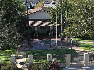
The Campo de Cahuenga, near the historic Cahuenga Pass in present-day Studio City, California, was an adobe ranch house on the Rancho Cahuenga where the Treaty of Cahuenga was signed between Lieutenant Colonel John C. Frémont and General Andrés Pico in 1847, ending hostilities in California between Mexico and the United States. The subsequent Treaty of Guadalupe Hidalgo of 1848, ceding California, parts of Colorado, Nevada, New Mexico, and Arizona to the United States, formally ended the Mexican–American War. From 1858 to 1861 the Campo de Cahuenga became a Butterfield Stage Station.
Rancho San Jose was a 22,340-acre (90.4 km2) Mexican land grant in northeastern Los Angeles County given in 1837 by Governor Juan Bautista Alvarado to Ygnacio Palomares and Ricardo Véjar. Today, the communities of Pomona, LaVerne, San Dimas, Diamond Bar, Azusa, Covina, Walnut, Glendora, and Claremont are located in whole or part on land that was once part of the Rancho San Jose.

The Sebastian Indian Reservation (1853-1864), more commonly known as the Tejon Indian Reservation, was formerly at the southwestern corner of the San Joaquin Valley in the Tehachapi Mountains, in southern central California.
Rancho Santa Teresa was a 9,647-acre (39.04 km2) Mexican land grant in present-day Santa Clara County, California given in 1834 by Governor José Figueroa to José Joaquín Bernal. The grant extended west from Coyote Creek to the Santa Teresa Hills, and included present-day Santa Teresa.

Rancho Campo de los Franceses was a 48,747-acre (197.27 km2) Mexican land grant in present-day San Joaquin County, California given in 1844 by Governor Manuel Micheltorena to Guillermo Gulnac. "Campo de los Franceses” which in English means “French Camp” refers to French-Canadian fur trappers who wintered there. The grant included present-day French Camp and Stockton.

Rancho Omochumnes, also known as "Rancho Río de los Cosumnes al Norte", was a 18,662-acre (75.52 km2) Mexican land grant in present day Sacramento County, California.
El Camino Viejo a Los Ángeles, also known as El Camino Viejo and the Old Los Angeles Trail, was the oldest north-south trail in the interior of Spanish colonial Las Californias (1769–1822) and Mexican Alta California (1822–1848), present day California. It became a well established inland route, and an alternative to the coastal El Camino Real trail used since the 1770s in the period.
Tejon Creek, originally in Spanish Arroyo de Tejon, is a stream in Kern County, California. Its headwaters are located on the western slopes of the Tehachapi Mountains, and it flows northwest into the southern San Joaquin Valley.
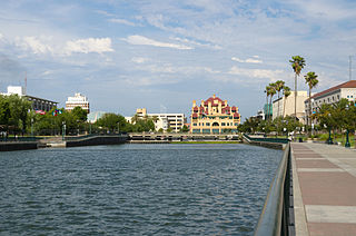
Stockton Channel is a waterway in California's Sacramento–San Joaquin River Delta. It runs 2.5 miles from the San Joaquin River-Stockton Deepwater Shipping Channel at the Port of Stockton to McLeod Lake in Downtown Stockton. The Stockton Channel is contained by levees, with Miners Levee is on the north side and Tuleburg Levee on the south side. The Mormon Slough branches off the Stockton Channel to the Southeast. The Smith Channel runs parallel to the north of the Stockton Channel. Interstate 5 crosses the Channel at its midpoint.

The Mission Vieja or Misión Vieja or the Old Mission was the first Spanish mission in the San Gabriel Valley. Mission Vieja was built in 1771 by what would become the fathers of the Mission San Gabriel Arcángel. The Mission Vieja site was designated a California Historic Landmark (No.161) on Jan. 11, 1935. The location of Mission Vieja is at what is now the South West corner North San Gabriel Blvd and North Lincoln Ave in Montebello, California. The site has a plaque marker and an El Camino Real Bell. Mission Vieja was the first building in the San Gabriel Valley and Los Angeles County. Father Juan Crespí picked the spot for Mission Vieja because water was available at what is now called the Whittier Narrows. The place for Mission Vieja was found in the expedition of Portolá in the summer of 1769. Gaspar de Portolá, Miguel Costansó and Father Juan Crespí recorded the expedition. In 1771 the fathers of Pedro Cambon and the fathers of Angel Somera, with a decree from Governor Pedro Fages, set out to build a mission in the Spanish Empire of Alta California, in what is now called the Los Angeles Basin. The first building was 45 by 18 feet made of adobe and wood. The roof was made with tule reeds from the waters of the Whittier Narrows. The building had around it a weak Palisade fence. Father Angel Somera and Father Pedro Cambon, both Franciscan missionaries, founded Mission Vieja, the original Mission San Gabriel Arcangel, on September 8, 1771; the location is today near the intersection of San Gabriel Boulevard and the Rio Hondo River. The establishment of the mission marked the beginning of the Los Angeles region's settlement by Spaniards and the fourth of twenty-one missions ultimately established along California's El Camino Real. The mission did well initially as a farm and cattle ranch. Six years after its founding, however, a destructive flood in 1776 led the mission fathers to relocate the mission five miles north, to its current location in what is the present day City of San Gabriel.
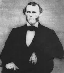
Alexis Godey also called Alec Godey and Alejandro Godey, born Alexander Godey, was a trapper, scout, and mountain man. He was an associate of Jim Bridger and was lead scout for John C. Frémont.

Murphy's Ranch, also called Murphy's Corral, is a historical site in Elk Grove, California in Sacramento County. The site of Murphy's Ranch is a California Historical Landmark No. 680 listed on May 11, 1959. At Murphy's Ranch on June 10, 1846, was the start of the Bear Flag Revolt and Bear Flag Rebellion.

Juan Brown (1799-1859), nickname Juan Flaco, known as the Paul Revere of California, rode from Los Angeles to San Francisco California in four days, 52 hours, in 1846, during the Mexican–American War. Juan "Flaco" Brown was send by Captain Archibald H. Gillespie at Fort Hill to due the Siege of Los Angeles, started on September 22, 1846. United States Army Troops were trapped in Pueblo de Los Ángeles, Alta California by José María Flores men. Juan "Flaco" Brown took word to Commodore Robert F. Stockton in San Francisco of the serious trouble the Gillespie's troops in Los Angeles were in.

Weber Point Home is a historical site in Stockton, California in San Joaquin County. The site of the former Weber Point Home is a California Historical Landmark No. 165, listed on January 11, 1935. The Weber Point Home was a built by Captain Charles M. Weber founder of Stockton. Weber was pioneer of California and built a two-story adobe-and-redwood house in 1850. At the time it was the largest house in Stockton. The house was built on the east end of the Stockton Channel. The house was surrounded by landscaped gardens built for his new wife Helen Murphy. Weber lived in the house till his death in 1881. The house was located on Center Street between Channel and Miner Street in Stockton. The Weber Point House was destroyed in a fire in 1917. The Weber Point House was the center of the 8,747 acre Mexican land grant Rancho Campo de los Franceses. The Rancho owned present day Stockton and lands south and east, most of the current San Joaquin County.


