Lindston Loch, South Ayrshire

Last updated

Lindston Loch
Lindston Loch site, Dalrymple.jpg
The site of Lindston Loch
Scotland relief location map.jpg
Red pog.svg
Lindston Loch
The location of The Lindston Loch, South Ayrshire
Location Dalrymple, South Ayrshire, Scotland
Coordinates 55°24′48″N4°34′22″W / 55.413425°N 4.572797°W / 55.413425; -4.572797
Type Freshwater loch
Primary inflows Direct rainfall, runoff, plus the Balsarroch and Boghall Burns
Primary outflows Dustyhall Burn that joins the Purclewan Burn.
Basin  countriesScotland
Max. length200 yards (180 m)
Max. width100 yards (91 m)
Surface area2.78 acres (1.13 ha)
Average depthShallow
Settlements Dalrymple

Lindston Loch (NS 37272 16195) was a small freshwater loch situated within a glacial 'kettle hole.' The loch lies in the South Ayrshire Council Area, Parish of Dalrymple, Scotland.

Contents

The loch

Lindston Farm, plantation and feeder burn. Lindston Loch and line of burn.jpg
Lindston Farm, plantation and feeder burn.

In the 1870s the OS map shows that the loch was circa 200 yards (180 metres) long by 100 yards (90 metres) wide, roughly oval in shape, and of an extent of 1.125ha or 2.78 acres however a section to the south-west had been infilled, possibly with quarrying waste from the nearby abandoned quarries. The loch was fed by burns running down from near Boghall and Balsarroch.

Drainage

The loch's drainage may have begun in the 18th century when Alexander Montgomerie, 10th Earl of Eglinton, was pursuing a number of agricultural improvements on his extensive estates and other landowners followed his example. Some drainage work may have taken place in the 1740s because of the improvements undertaken to provide employment for Irish estate workers during the Irish potato famines of the 1740s and the mid 19th centuries. Many drainage schemes also date to the end of World War I when many soldiers returned en masse to civilian life. [1]

Uses

An outflow once ran down towards Dustyhall and joined the Purclewan Burn that powered the mill at Burnton. It is recorded that drainage works were carried out in 1790. [2]

Curling matches are recorded at the loch on 15 January 1850 and on 19 December 1844. A curling pond was still recorded in the late 1890s. [3]

Archaeology

Perclewan Mill. Perclewan Mill development, Dalrymple.jpg
Perclewan Mill.

In 1790 Smith records that a bronze tripod ewer was found in Lindston Loch, measuring 9+58 inches high, by 3+14 inches across the mouth, spreading out to 4+18 inches. It has a spout and handle and is regarded being of late medieval origin; for many years it was kept at the Dalrymple Manse. [4] A bronze tripod ewer, with spout and handle, almost identical to the Lindston Loch specimen, was found at nearby Skeldon. [5] The old Roman road from the Solway Firth and the Clyde ran near here, passing from Causeway Farm onto Perclewan and Lindston. The above mentioned ewer was found near this road; [6] a glazed pitcher of earthenware was found at Perclewan near the old road in 1833, bearing the figure of a man's face and hands on the front. [6]

Ewer found in 1790 in Lindston Loch. Lindston Loch Ewer, Dalrymple.jpg
Ewer found in 1790 in Lindston Loch.

Lindston Camp sat above the loch, on the nearly level summit of a broad ridge 400 feet above the sea. A circular wet ditch, 21 feet wide and 2 or 3 deep to the surface of the weedy water, encloses a space 130 feet in diameter, scarcely rising above the surface of the surrounding field, and has no trace of a rampart. [2] The earthwork remains may possibly been a henge commanding magnificent views in all directions. The entrance has been in the east where a causeway (7 m broad) crosses the ditch. [7]

Etymology

The meaning of Lindston may derive from Lind, the Scots for a lime ( Tilia species) or linden tree. It was also used in the general sense of woodland. The overall sense being that of a 'rocky outcrop within woodland'. [8]

Natural history

The loch in 1846 was well stocked with pike, perch, and eels, and was frequented by wild-duck, teal, widgeon, and other aquatic fowl. [9] An extensive woodland extends towards Lindston Farm and large areas of reeds ( Phragmites species) are present. The loch site recorded as a wildlife site within South Ayrshire. The OS maps of the 1870s show a plantation beneath Lindston Farm and extensive areas of willow scrub have developed.

Nelly Kilpatrick

When Robert Burns was 15 he met his first young love, Nelly Bone, better known as Nelly Kilpatrick in this part of Ayrshire. Nelly was the daughter of the Purclewan hamlet miller and they met when William Burns hired some extra help to bring in the harvest while they were at nearby Mount Oliphant Farm. It was with Nelly in mind that he wrote his first song "Handsome Nell" –

O once I lov'd a bonnie lass,
Aye, and I love her still;
And whilst that virtue warms my breast,
I'll love my handsome Nell.

Some years later Burns wrote of this song, saying –

"I never had the least thought or inclination of turning poet till I got once heartily in love, and then rhyme and song were, in a manner, the spontaneous language of my heart. I remember I composed it in a wild enthusiasm of passion, and to this hour I never recollect it but my heart melts, and my blood sallies at the remembrance." [10]

See also

Related Research Articles

Riccarton is a village and parish in East Ayrshire, Scotland. It lies across the River Irvine from Kilmarnock, this river forming the boundary between Riccarton and Kilmarnock parishes, and also between the historical districts of Kyle and Cunningham. The name is a corruption of 'Richard's town', traditionally said to refer to Richard Wallace, the uncle of Sir William Wallace. The parish also contains the village of Hurlford.

<span class="mw-page-title-main">Lambroughton Loch</span> Drained freshwater loch in North Ayrshire, Scotland

Lambroughton Loch or Wheatrig Loch was situated in a low-lying area between the farms and dwellings of Hillhead, Lambroughton, Wheatrig, Titwood and Lochridge mainly in the Parish of Dreghorn, North Ayrshire. The loch was mainly fed by the Lochridge Burn, the Garrier Burn and surface runoff, such as from the old rig and furrows indicated by Roy's maps of the mid-18th century. The loch outflow was via the Lochridge Burn that runs into the Garrier Burn, passes the site of the old Lochend habitation and into the Bracken Burn near Little Alton. The rivulet or watercourse is known as the Garrier Burn beyond this point.

<span class="mw-page-title-main">Lochlea, South Ayrshire</span> Drained freshwater loch in South Ayrshire, Scotland

Lochlea or Lochlie was situated in a low-lying area between the farms and dwellings of Lochlea and Lochside in the Parish of Tarbolton, South Ayrshire, Scotland. The loch was natural, sitting in a hollow created by glaciation. The loch waters ultimately drained via Fail Loch, the Mill Burn, and the Water of Fail. It is well-documented due to the presence of a crannog that was excavated and documented circa 1878, and its association with the poet Robert Burns, who lived here for several years whilst his father was the tenant. Lochlea lies 2+12 miles northeast of Tarbolton, and just over three miles northwest of Mauchline.

<span class="mw-page-title-main">Halket Loch</span> Drained freshwater loch in East Ayrshire, Scotland

Halket Loch' also known as Halkhead or Halketh, was situated in the mid-Ayrshire clayland near Lugton. It is visible as a surface depression in pastureland, sometimes partially flooded, situated in a low-lying area close to farms and dwellings of East, North and Middle Halket and Craighead in the Parish of Dunlop, East Ayrshire, Scotland. The loch was natural, sitting in a hollow created by glaciation. The loch waters drained via the Glazert Water that joins the Annick Water.

<span class="mw-page-title-main">Littlestane Loch</span> Former lake in Irvine, Scotland

Littlestane Loch, was situated in the mid-Ayrshire clayland near Stanecastle, Irvine, North Ayrshire, Scotland. It is nowadays (2011) only visible as an area of permanent water in the Scottish Wildlife Trust Sourlie Nature Reserve. The loch was natural, sitting in a hollow created by glaciation. The loch waters outflow was via the Red Burn that flows into the River Garnock. The site of Littlestane Loch site is partly built over and much of the site is now public open space lying within the Parish of Girdle Toll.

<span class="mw-page-title-main">Helenton Loch</span> Drained freshwater loch in South Ayrshire, Scotland

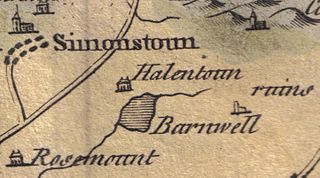
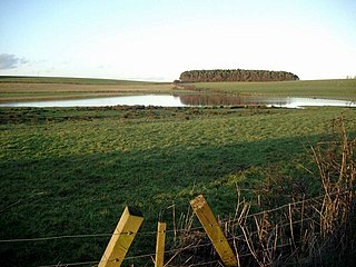
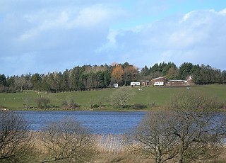
Helenton Loch was situated in a low lying area between the farms and dwellings of Helentongate, Mains, and Burnbank in the Parish of Symington, South Ayrshire, Scotland. The loch was natural, sitting in a hollow, a kettle hole, created by glaciation. The loch waters ultimately drained via the Pow Burn. Helenton Hill is a prominent landmark to the west of the old loch site. The nearby lands of Rosemount were in 1549 known as 'Goldring' and were the property of the Schaws of Sornbeg.

<span class="mw-page-title-main">Fail Loch</span> Drained freshwater loch in South Ayrshire, Scotland

Fail Loch or Faile Loch was situated in a low-lying area near the old monastery of Fail in the Parish of Tarbolton, South Ayrshire, Scotland. The old Lochlea Loch lies nearby and its waters still feed into Fail Loch via the Mill Burn.

<span class="mw-page-title-main">Knockewart Loch</span> Drained freshwater loch in North Ayrshire, Scotland

Knockewart Loch or Loch Jargon was situated in a hollow lying area beneath Knockewart Hill in the Parish of Ardrossan, North Ayrshire, Scotland. The old loch has become largely drained and overgrown since the late 19th century.

<span class="mw-page-title-main">Galrigs Loch (South Ayrshire)</span> Old freshwater loch in South Ayrshire, Scotland

The Galrigs Loch was a substantial freshwater loch situated in low lying area between Newfield and Dundonald in South Ayrshire, Scotland. It was drained in the early 18th century.

<span class="mw-page-title-main">Clevens Loch, Ayrshire</span> Old freshwater loch in South Ayrshire, Scotland

Clevens Loch was a substantial freshwater loch situated in a low-lying area below Clevance Farm and Langholm Farm in Dundonald parish, South Ayrshire, Scotland.

<span class="mw-page-title-main">Loch of Trabboch</span> Drained freshwater loch in East Ayrshire, Scotland

The Loch of Trabboch or Dalrympleston Loch (NS440211) was situated in a low-lying area below the old Castle of Trabboch, once held by the Boyd family in the Parish of Stair, East Ayrshire, Scotland.

<span class="mw-page-title-main">Loch Fergus</span> Freshwater loch in South Ayrshire, Scotland

Loch Fergus is a freshwater post-glacial "Kettle Hole" sometimes recorded as Fergus Loch. It is quite visible and is situated in a low-lying area close to the B742 road between the farms and dwellings of Trees, Lochfergus and Bowmanston in the Parish of Ayr, South Ayrshire, Scotland. The loch lies to the north of Martnaham Loch, four miles east-southeast of Ayr. It drains to the southwest into the Snipe Loch.

<span class="mw-page-title-main">Martnaham Loch</span> Freshwater loch in South Ayrshire, Scotland

Martnaham Loch is a freshwater loch lying across the border between East and South Ayrshire Council Areas, two kilometres from Coylton, in the parishes of Coylton and Dalrymple, three miles from Ayr. The loch lies along an axis from northeast to southwest. The remains of a castle lie on a possibly artificial islet within the loch. The Campbells of Loudoun once held the lands, followed by the Kennedys of Cassillis.

<span class="mw-page-title-main">Carcluie Loch</span> Freshwater loch in South Ayrshire, Scotland

Carcluie Loch is a small freshwater loch in the South Ayrshire Council Area, lying in a glacial Kettle Hole, Parish of Dalrymple, Scotland.

<span class="mw-page-title-main">Kerse Loch</span> Freshwater loch in East Ayrshire, Scotland

Kerse Loch, also recorded as Carse Loch (1841) is a small freshwater loch in the East Ayrshire Council Area, lying in a glacial Kettle Hole, Parish of Dalrymple, Scotland.

<span class="mw-page-title-main">Nelly Kilpatrick</span>

Nelly or Nellie Kilpatrick, Helen Kilpatrick or later Nelly Bone (1759–1820). Nelly was possibly Robert Burns's first love and muse as stated by Isabella Burns.

Nelly Blair, later Nelly Smith is sometimes suggested as being Scottish poet Robert Burns' first love.

<span class="mw-page-title-main">Earlston, East Ayrshire</span> Human settlement in Scotland

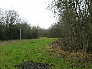
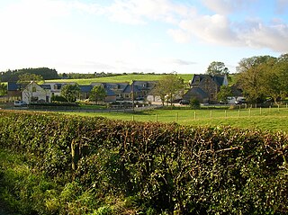
Earlston is a hamlet in Riccarton, East Ayrshire, Scotland. The habitation dates from at least the early 18th century and is near Caprington Castle and Todrigs Mill. It was for many years the site of a large sawmill and a mine pumping engine, and had sidings of the Glasgow and South-Western Railway's Fairlie Branch.

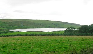
What now survives of the old Caprington Loch (NS402352) is situated near Earlston, Riccarton, East Ayrshire, Scotland. The loch was a natural feature, sitting in a hollow on the old Caprington Castle estate. The loch waters drain via the Todrigs Burn that flows into the River Irvine to the east of Gatehead village. It was partly drained, probably sometime after the 1820s, as were so many other lochs, as part of 18th and 19th centuries extensive agricultural improvements and the only area of open water that remains does so as it was once used as a curling pond for the Caprington Castle Estate owners and their employees or tenants.

<i>Handsome Nell</i> Poem by Robert Burns

Handsome Nell was the first song written by Robert Burns, often treated as a poem, that was first published in the last volume of James Johnson's Scots Musical Museum in 1803 (No.551) with an untitled tune. Burns recorded in holograph on page three of his first Commonplace Book that he wrote the song or Rhyme at the age of only fifteen whilst living at Mount Oliphant Farm, it is regarded as his earliest production, inspired by a farm servant aged fourteen, named either Nelly Kilpatrick or Nelly Blair. Some confusion exists as he also gave his age as 16 in his autobiographical letter to Dr. Moore; the autumn of 1774 is generally accepted.

References

Notes

  1. MacIntosh, Pages 37 & 39
  2. 1 2 Smith, Page 173
  3. Curling Pond Sites Retrieved : 13 September 2011
  4. Arch Hist Col. Page 47
  5. John Smith Retrieved : 11 September 2011
  6. 1 2 Paterson, Page 395
  7. Canmore Retrieved : 11 September 2011
  8. Scots Dictionary Retrieved : 11 September 2011
  9. Ayrshire Roots Retrieved : 11 September 2011
  10. The World Burns Club. Archived 17 December 2011 at the Wayback Machine Retrieved : 29 January 2012

Sources

  1. Archaeological & Historical Collections relating to the counties of Ayrshire & Wigtown. V. IV. Edinburgh : Ayr Wig Arch Soc. 1884.
  2. MacIntosh, Donald (2006). Travels in Galloway. Glasgow : Neil Wilson. ISBN   1-897784-92-9.
  3. Paterson, James (1863–66). History of the Counties of Ayr and Wigton. II. – Kyle. Edinburgh: J. Stillie.
  4. Smith, John (1895). Prehistoric Man in Ayrshire. London : Elliot Stock.