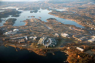
Fornebu is a peninsular area in the suburban municipality of Bærum in Norway, bordering western parts of Oslo.

Gamle Oslo is a borough of the city of Oslo, Norway. The name means "Old Oslo", and the district contains Old Town.

Sinsen is a mixed residential and commercial area in Grünerløkka borough of Oslo, Norway. The westernmost part of Sinsen is part of the borough Nordre Aker.
Bygdøy or Bygdø is a peninsula situated on the western side of Oslo, Norway. Administratively, Bygdøy is part of the borough of Frogner. It historically was part of Aker Municipality and became part of Oslo in 1948.

The Oslofjord is an inlet in southeastern Norway. The 120-kilometre (75 mi) fjord begins at the small village of Bonn in Frogn Municipality and stretching northwards to the city of Oslo, and then curving to the east and then south again. It then flows south to an imaginary line running between the Torbjørnskjær Lighthouse and Færder Lighthouse where it becomes part of the Skagerrak strait. The Skagerrak connects the North Sea and the Kattegat sea area, which leads to the Baltic Sea. The Oslofjord is not a fjord in the geological sense, but in the Norwegian language, the term fjord can refer to a wide range of waterways including inlets such as this one.

Hovedøya is one of several small islands off the coast of Oslo, Norway in the Oslofjord. The island is quite small, no more than 800 metres across in any direction, the total area is 0,4 square kilometre. It is well known for its lush and green nature, with a wide variety of trees, bushes and flowers. For many, many years there was a military base on the island.

Oslo Fergene is a passenger ferry operator in Oslo, Norway.
Aktieselskapet Det Norske Luftfartsrederi or DNL was Norway's first scheduled airline, founded in 1918 and operated services between Bergen, Haugesund and Stavanger in 1920. It operated Supermarine Channel flying boats. It was also one of the seven founding members of the International Air Traffic Association, the predecessor of the International Air Transport Association.
Gressholmen is an islet located in the Oslofjord, just south of central Oslo. Administratively it belongs to the borough of Gamle Oslo.

Gressholmen Airport was a water aerodrome situated the island of Gressholmen in Oslo, Norway. It served as the main airport for Oslo from 1927 to 1939, along with Kjeller Airport. The aerodrome consisted of docks, a landing ramp, terminal building and a hangar and used a section of the Oslofjord as its runway. Being located on an island it was necessary to transport passengers by boat to the island. The airport only operated during the summer, typically from May through September.

Vippetangen is the southern tip of the Akersnes peninsula in central Oslo, Norway, located southeast of Akershus Fortress and bounded on three sides by the Oslofjord. It has in the past served as an important part of the port of Oslo. The area is currently undergoing urban renewal as part of the Fjord City development.

Sjursøya is a peninsula located in Oslo, Norway. The peninsula is entirely used by the Port of Oslo as a container and petroleum port, and serves as the primary oil port for Eastern Norway.

Maridalen is a valley just north of Oslo, Norway, just above the suburb of Kjelsås. Considering that Maridalen is within the Oslo city limits, Maridalen has a very low population density. The valley consists of forests, lakes and agricultural land. Most of the valley is made up of the lake Maridalsvannet, which serves as the primary source of drinking water for 90% of Oslo's population. The only hydroelectric powerplant within the City of Oslo, Hammeren Hydroelectric Power Station is located at Brekke in Maridalen. The valley is a popular recreational area with many hiking trails, cycling tracks for summer usage, and groomed cross-country trails in winter. Both the lake and valley are protected. Maridalen Church and the church ruins of the ancient St. Margaret's Church are located north of Maridalsvannet. A bus route runs along Maridalen, starting at Nydalen Subway Station.
Bleikøya is an island in the inner part of Oslofjord, in the municipitality of Oslo. It is located between Hovedøya and Sjursøya. From the late 19th century, a sanatorium for children suffering from scrofula was located on the island.

Nakholmen is an uninhabited island in the inner part of Oslofjord, in the municipitality of Oslo. It is located west of Lindøya and southeast of Bygdøy. The island has more than 180 weekend cottages.

Ormøya is an inhabited island in the inner part of Oslofjord, in the municipality of Oslo. It is located north of the island Malmøya and west of the mainland at Bekkelaget / Nordstrand. A bridge over the strait Ormsundet connects the island to the mainland. The island covers an area of 0.18 square kilometres (0.069 sq mi) Ormøy Church, designed by architect Bernhard Steckmest, was built in the 1890s. On the island there are beaches, boating ports and a small park.

Ulvøya is an inhabited island in the inner part of Oslofjord, in the municipality of Oslo. It is located east of the island Malmøya and west of the mainland at Nordstrand. A bridge over the strait Ulvøysundet connects the island to the mainland. The island covers an area of 0.3 square kilometres (0.12 sq mi).

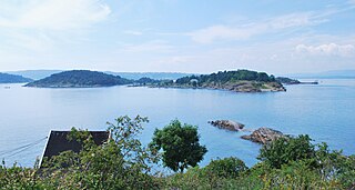
Danmark is an islet located near Sandvika in the Municipality of Bærum, Norway.
Bergen Airport, Sandviken is a water airport and heliport situated in the Sandviken neighborhood of Bergen, Norway. The aerodrome is located on the artificial peninsula of Kristiansholm. It is currently serving seaplanes and helicopters operated by Fonnafly aimed at air taxi services at cruise ship tourists. The airport is owned by Bergen Municipality through Bergen Port Authority and is part of the Bergen Port. Operations are carried out by Fonnafly.

