The Federal University of São Carlos is a public research university located in São Carlos, state of São Paulo, Brazil.
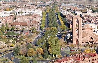
Pozuelo de Alarcón is a municipality in the Community of Madrid, Spain. Bordering the Moncloa-Aravaca district of Madrid proper to its west, Pozuelo de Alarcón is surrounded by large Mediterranean pine-tree forests: the Casa de Campo, the Monte del Pardo, and the Monte del Pilar. As of 2022, it ranks as the wealthiest municipality in Spain. La Finca, an isolated luxury residential area known by its affluent residents, most notably football players, lies within the municipality bounds.

The Sistema de Tren Eléctrico Urbano or SITEUR is an urban rail transit system serving the Guadalajara metropolitan area, in the municipalities of Guadalajara, Zapopan and Tlaquepaque, in the state of Jalisco, Mexico. It is owned and operated by the state of Jalisco.
The Secretariat of Welfare is the government department in charge of social development efforts in Mexico. The Secretary of Welfare is a member of the Executive Cabinet, and is appointed at the discretion of the President of the Republic. The Secretariat of Welfare aims to eliminate poverty through comprehensive, collectively responsible human development, achieve adequate levels of well-being with adjustment to government policies, and improvement through social, economic and political factors in rural and urban areas to enhance local organization, city development and housing.

The General Bartolomé Mitre Railway (FCGBM), named after the former Argentine president Bartolomé Mitre, is one of the six state-owned Argentine railway lines formed after President Juan Perón's nationalisation of the railway network in 1948 and one of the largest of Argentina. The six divisions, managed by Ferrocarriles Argentinos were later broken up during the process of railway privatisation beginning in 1991 during Carlos Menem's presidency.

The Karlsruhe Stadtbahn is a German tram-train system combining tram lines in the city of Karlsruhe with railway lines in the surrounding countryside, serving the entire region of the middle upper Rhine valley and creating connections to neighbouring regions. The Stadtbahn combines an efficient urban railway in the city with an S-Bahn, overcoming the boundary between trams and trains. Its logo does not include the green and white S-Bahn symbol used in other German suburban rail systems and the symbol is only used at stops and stations outside the inner-city tram-operation area.

Circumferential Road 5 (C-5), informally known as the C-5 Road, is a network of roads and bridges which comprise the fifth beltway of Metro Manila in the Philippines. Spanning some 43.87 kilometers (27.26 mi), it connects the cities of Las Piñas, Parañaque, Pasay, Pasig, Quezon City, Taguig, and Valenzuela.

The Guadalajara trolleybus system serves Guadalajara, the capital city of the state of Jalisco in Mexico.
The Metro Manila Dream Plan, formally titled the Roadmap for Transport Infrastructure Development for Metro Manila and Its Surrounding Areas, refers to a 2014 integrated plan for improving the transport system in Metro Manila, Philippines, with the hope of turning it into a focal point for addressing Metro Manila's interlinked problems in the areas of transportation, land use, and environment.

The TEG-15 is a model of light rail vehicle manufactured by Bombardier Transportation for the Sistema de Tren Eléctrico Urbano. Twelve other firms competed for the Guadalajara contract. The contract was awarded in late 2015, and was completed in approximately two years.

Urban flooding is the inundation of land or property in cities or other built environment, caused by rainfall or coastal storm surges overwhelming the capacity of drainage systems, such as storm sewers. Urban flooding can occur regardless of whether or not affected communities are located within designated floodplains or near any body of water. It is triggered for example by an overflow of rivers and lakes, flash flooding or snowmelt. During the flood, stormwater or water released from damaged water mains may accumulate on property and in public rights-of-way. It can seep through building walls and floors, or backup into buildings through sewer pipes, cellars, toilets and sinks.

The Zapopan Centro metro station is the fifteenth station in Line 3 of the Guadalajara urban rail system, south-east to north-west, and the fourth in the opposite direction.

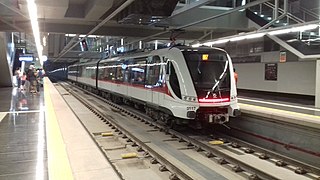
Ávila Camacho railway station is the interchange station between SITEUR's Lines 1 and 3 in Guadalajara, Mexico.

La Normal is the tenth station of Line 3 of the Guadalajara Urban Electric Train System from south-east to north-west and the eighth in opposite direction. It's one the underground stations of said line, as well as the northernmost station from the underground tunnel before exiting to the surface towards the elevated viaduct Guadalajara-Zapopan.

Guadalajara Centro railway station is the ninth station of Line 3 of Guadalajara's SITEUR from south-east to north-west, and the tenth in the opposite direction; it is also a station with a large influx of passengers because it acts as a transfer station with Plaza Universidad on Line 2 of the system.
Lázaro Cárdenas is the second station of Line 3 of the Guadalajara Urban Electric Train System from south-east to north-west, and the seventeenth in opposite direction.

Line 1 of the Guadalajara Urban Electric Train System opened on 1 September 1989. It is the oldest line of the Sistema de Tren Eléctrico Urbano (SITEUR), or Urban Electric Train System in Guadalajara. It was previously coloured blue, but after the stations were remodeled between 2014 and 2018 it is now red.
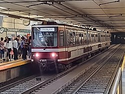
Line 3 of the Guadalajara Urban Electric Train System is the third public transport railway line in the Guadalajara metropolitan area (México) and currently its longest. The line connects the Historical Centres of Zapopan, Guadalajara and Tlaquepaque, through the Diagonal Metropolitan Vial Corridor; consisting of Juan Gil Preciado, Juan Pablo II, Manuel Ávila Camacho, Alcalde / 16 de Septiembre and Revolución / Francisco Silva Romero avenues, from the Arcos de Zapopan neighbourhood until the Central Camionera Oriente of Guadalajara. It has 18 stations from south-east to north-west, of which 13 are elevated and 5 are underground. It stretches along 21.5 km. It is estimated that the line moves 233,000 daily passengers.

Mi Macro Periférico is the second BRT line in the Guadalajara metropolitan area. It runs on 41.6 kilometres (25.8 mi) along the Anillo Periférico Manuel Gómez Morin from its crossing with the Artesanos Avenue until the Solidaridad Iberoamericana Avenue, commonly known as Carretera a Chapala. It has a total of 42 stations between Carretera a Chapala and Barranca de Huentitán. The line has connections with line 1 and line 3 of the Guadalajara light rail system, lines 1 and 4 of SITREN and Mi Macro Calzada.

Mercado del Mar is the sixteenth station of the Line 3 of the Sistema de Tren Eléctrico Urbano of Guadalajara from south-east to north-west and the third in the opposite direction.