The Tibet Autonomous Region (TAR) or Xizang Autonomous Region, called Tibet or Xizang for short, is a province-level autonomous region in southwest China. It was formally established in 1965 to replace the Tibet Area, an administrative division the People's Republic of China (PRC) took over from the Republic of China (ROC) about five years after the dismissal of the Kashag by the PRC following the 1959 Tibetan uprising, and about 13 years after Tibet's incorporation into the PRC in 1951.

The Venetian Macao is a luxury hotel and casino resort in Macau owned by the American Las Vegas Sands company. The Venetian is a 39-story, casino hotel on the Cotai Strip in Macau. The 10,500,000-square-foot (980,000 m2) Venetian Macao is modeled on its sister casino resort The Venetian Las Vegas. The Venetian Macao is the largest casino in the world, the largest single structure hotel building in Asia, and also the seventh-largest building in the world by floor area.

Xainza County, also Shantsa, Shentsa, is a county within Nagqu of the Tibet Autonomous Region of China. In 1999 the county had a population of 16,190.
Lhasa West railway station is a railway station in Lhasa, Tibet Autonomous Region, People's Republic of China.

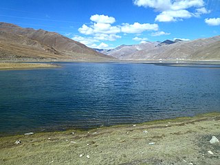
Baidi is a township in Nagarzê County, Shannan Prefecture, Tibet Autonomous Region of China. It lies on a lake, at an altitude of 4,919 metres (16,141 ft) and is located about 121 kilometres (75 mi) south-west of Lhasa. The village of Baidi is located in the township.
Cha'gyungoinba is a village in the Tibet Autonomous Region of China. It lies at an altitude of 4,725 metres. The village has a population of about 33. It is located near Nam Co lake.
Dogyaling is a village in the Tibet Autonomous Region of China. It lies at an altitude of 4,631 metres. The village has a population of about 28 people.
Ngarzhag is a village in the Tibet Autonomous Region of China.
Raka is a village in Danga Township in Saga County in the Shigatse Prefecture of the Tibet Autonomous Region of China. It lies along the G219 road near the junction with the northern heading S206 road on the road to Qierexiang, roughly 50 kilometres (31 mi) east of Saga at an altitude of 5,565 metres (18,258 ft). Historically it lay in the province of Tsang. Raka is very well connected, connected by provincial highway 206 to Coqen in the north, Saga in the southwest and Lhatse, Shigatse and Lhasa to the east. Several kilometres to the east is the village of Kyêrdo. An "enormous tributary" called the Raka Tsanpo flows nearby and the saline lake of Raka Lake is also located in the vicinity.
Ramba is a village and township in the Tibet Autonomous Region of China. It is located 107 kilometres south of Lhasa in Rinbung County, Shigatse Prefecture. There is also a lake, Ramba Co in the area.
Sewu, Sêwa or Sewuxiang is a village and township-level division of Amdo County in the Nagqu Prefecture of the Tibet Autonomous Region, in China. It lies near Qixiang Lake. The township covers an area of 5,647 kilometres (3,509 mi) and in 2004 it had a population of about 1,000. The principal economic activity is animal husbandry, pastoral yak, goat, sheep, and so on.
Zharen, also Zaring or Zharencun is a small town and township-level division of Amdo County in the Nagqu Prefecture of the Tibet Autonomous Region, in China. It is located at the side of the G109 road, 45 kilometres (28 mi) south of Amdo Town on the road from Nagchu Town, and approximately 20 kilometres (12 mi) east of the southern tip of Cona Lake.

Ggaba is a neighborhood within the city of Kampala in the Central Region of Uganda.
Bangda Lake (Tibetan: པང་བཏགས་མཚོ, Wylie: pang btags mtsho ; Chinese: 邦达错; pinyin: Bāngdá Cuò), also Bangdag or Bangdacuo, is a glacial lake in Ngari Prefecture in the northwest of the Tibet Autonomous Region of China. It lies in the western Kunlun Mountains, to the southeast of Guozha Lake. Located at an altitude of 4902 metres, it covers an area of 106 square kilometres with a maximum depth of 21.6 metres and contains 90 glaciers.

Guozha Lake, also Gozha Co, Gozha Tso or Guozhacuo, also known as Lake Lighten, is a glacial lake in Rutog County in the Ngari Prefecture in the northwest of the Tibet Autonomous Region of China. It lies in the western Kunlun Mountains to the northwest of Bangda Lake, not far from the regional border with Xinjiang. Located at an altitude of 5080 metres, it covers an area of 244 square kilometres with a maximum depth of 81.9 metres and his drainage basin contains 62 glaciers.
Dongqiao is a village in Amdo County of Nagqu Prefecture, Tibet Autonomous Region, People's Republic of China. The village of Dongqiao is noted for its hot spring, Jipu. Dongqiao geologically gives its name to the wider Dongqiao-Nagqu Subregion and the Banggong-Dongqiao-Nujiang fault zone.
Zhujia is a village in Lhünzhub County in the Lhasa Prefecture of Tibet Autonomous Region, in China. It lies 25.5 kilometres (15.8 mi) by road west of Lhünzhub, near Hutoushan Reservoir. By road it is 90 kilometres (56 mi) from Lhasa, but considerably nearer to the north as the road forks around much further to the east first before approaching Lhünzhub and Zhujia. It appears to have been a township of Lhünzhub County, covering 126 square kilometers, with a population of 4000 at one point, with 12 village committees. However, the National Bureau of Statistics now lists Zhujia as a village and no longer as an official township-level division of Lhünzhub County.
Cuoma, or Cuomaxiang is a village and township-level division of Amdo County in the Nagqu Prefecture of the Tibet Autonomous Region, in China. It is located roughly 30 kilometres (19 mi) southwest of Amdo Town near the northern bank of Cona Lake. It covers an area of 5,098 square kilometres (1,968 sq mi) and as of 2004 had a population of about 3,100. Cuoma township of Amdo County has existed since 1960 and was further expanded in 1987, but Cuoma has also been listed under the jurisdiction of Seqing Township of Nyainrong County. The principal economic activity is animal husbandry, pastoral yak, goat, sheep, and so on.
Qiangma, also Qangma or Qiangmazhen is a small town and township-level division of Amdo County in the Nagqu Prefecture of the Tibet Autonomous Region, in China. It is located just south of Zi Getangcuo Lake, 90.7 kilometres (56.4 mi) southwest of Amdo Town. It covers an area of 5,467 square kilometres (2,111 sq mi) and as of 2004 it had a population of about 1700. The principal economic activity is animal husbandry, pastoral yak, goat, sheep, and so on.
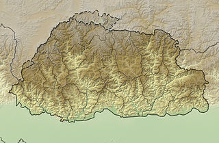
Kangphu Kang or Shimokangri is a mountain in the Himalayas. At 7,204 m (23,635 ft) above sea level it is the 107th highest mountain in the world. The peak is located on the border of Bhutan and China (Tibet).