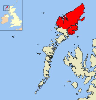
The Isle of Lewis or simply Lewis is the northern part of Lewis and Harris, the largest island of the Western Isles or Outer Hebrides archipelago in Scotland. The two parts are frequently referred to as if they were separate islands. The total area of Lewis is 683 square miles (1,770 km2).

The Harz is a highland area in northern Germany. It has the highest elevations for that region, and its rugged terrain extends across parts of Lower Saxony, Saxony-Anhalt, and Thuringia. The name Harz derives from the Middle High German word Hardt or Hart. The name Hercynia derives from a Celtic name and could refer to other mountain forests, but has also been applied to the geology of the Harz. The Brocken is the highest summit in the Harz with an elevation of 1,141.1 metres (3,744 ft) above sea level. The Wurmberg is the highest peak located entirely within the state of Lower Saxony.

Freiberg is a university and former mining town in Saxony, Germany. It is a Große Kreisstadt and the administrative centre of Mittelsachsen district.

Heilbad Heiligenstadt is a spa town in Thuringia, Germany. It is the capital of the Eichsfeld district.

Jüterbog is a historic town in north-eastern Germany, in the Teltow-Fläming district of Brandenburg. It is on the Nuthe river at the northern slope of the Fläming hill range, about 65 km (40 mi) southwest of Berlin.

Bad Wilsnack is a small town in the Prignitz district, in Brandenburg, Germany. The former pilgrimage site of the Holy Blood of Wilsnack has been officially recognised as a spa town (Bad) since 1929. It is the administrative seat of the Amt Bad Wilsnack/Weisen.
Ruggell is a municipality of Liechtenstein. It is the northernmost and lowest elevated municipality. As of 2019, it has a population of 2,322.

Bolatice is a municipality and village in Opava District in the Moravian-Silesian Region of the Czech Republic. It has about 4,500 inhabitants. It is part of the historic Hlučín Region.
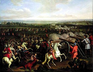
The Battle of Fehrbellin was fought on June 18, 1675, between Swedish and Brandenburg-Prussian troops. The Swedes, under Count Waldemar von Wrangel, had invaded and occupied parts of Brandenburg from their possessions in Pomerania, but were repelled by the forces of Frederick William, the Great Elector, under his Feldmarschall Georg von Derfflinger near the town of Fehrbellin. Along with the Battle of Warsaw (1656), Fehrbellin was crucial in establishing the prestige of Frederick William and Brandenburg-Prussia's army.
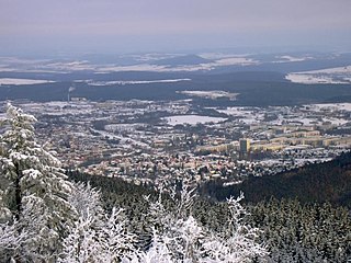
Ilmenau is a town in Thuringia, central Germany. It is the largest town within the Ilm district with a population of 38,600, while the district capital is Arnstadt. Ilmenau is located approximately 33 km south of Erfurt and 135 km north of Nuremberg within the Ilm valley at the northern edge of the Thuringian Forest at an elevation of 500 metres.

Kandern is a city in southwestern Germany in the state of Baden-Württemberg, in the Kreis (district) of Lörrach. During the Battle of Schliengen, in which the French Revolutionary army fought the forces of Austria, the battle lines of both armies ended in Kandern. It is not far from a tripoint where the three countries Germany, France and Switzerland meet and is one of the smallest cities in Germany.

Fehrbellin is a municipality in Germany, located 60 km NW of Berlin. It had 9,310 inhabitants as of 2005, but has since declined to 8,606 inhabitants in 2012.

Hille is a community in the Kreis Minden-Lübbecke in the north of East Westphalia, Germany, with approximately 16,000 inhabitants. It was created in 1973 in the framework of the community restructuring of North Rhine-Westphalia through the combining of nine communities of the Minden countryside. The community is named after Hille its largest village. The geography of the community belongs to that of the North German Plain, from its lowest altitude of 45 metres it rises to 251 metres on the ridge of the Wiehengebirge at its southern border.

Lehrte is a town in the district of Hanover, in Lower Saxony, Germany. It is situated approximately 17 km east of Hanover. In the 19th century Lehrte was the most important railway junction in the former Kingdom of Hanover. As of the 21st century, it has a population of 43,000.

Nagykovácsi is small town located in Budakeszi District, in the western part of Pest county, central Hungary. It is situated some 15 km (9 mi) north-west of the centre of Budapest, in a valley. According to the 2011 census, the population amounted to 7095, though this figure does not include individuals who own property as a secondary residence in the town. Nagykovácsi today attracts tourists and new residents alike, due to its proximity to the capital city, attractive and peaceful setting, surrounding by hills and forests. Some of the nearby areas have been designated conservation areas—Budai Tájvédelmi Körzet —in order to protect several of its rare species of flora. Its location has contributed to the town's development in recent decade. The American International School of Budapest chose Nagykovácsi as the site for its new campus in 2000.

Storm's stork is a medium-sized stork species that occurs primarily in lowland tropical forests of Indonesia, Malaysia and southern Thailand. It is considered to be the rarest of all storks, and is estimated to number less than 500 wild individuals throughout its geographic range. The population has long been in decline and the primary cause is widely considered to be deforestation of its native habitat.
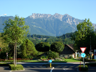
Bernau am Chiemsee is a municipality in the district of Rosenheim in Germany on the Lake Chiemsee, and a Luftkurort.

Boží Dar is a town in Karlovy Vary District in the Karlovy Vary Region of the Czech Republic. It has about 300 inhabitants. Situated in the Ore Mountains at 1,028 m (3,373 ft) above sea level, it is considered the highest town in the Czech Republic. The town is part of the Abertamy – Boží Dar Mining Landscape, which is a UNESCO World Heritage Site as part of Ore Mountain Mining Region.

The Kahayan River, or Great Dayak River, is the second largest river after the Barito River in Central Kalimantan, a province of Indonesia in Kalimantan – the Indonesian part of the island of Borneo. With a total length of 658 km (409 mi) and with a drainage basin of 15,500 km2 (6,000 sq mi) in South Kalimantan, Indonesia. Mean annual discharge 1,178 m3/s (41,600 cu ft/s). The provincial capital Palangkaraya lies on the river. The main inhabitants are Dayaks, who practice slash-and-burn rice cultivation and pan for gold on the upper reaches. The lower Kayahan flows through a rich and unusual environment of peat swamp forests, which has been severely degraded by an unsuccessful program to convert a large part of the area into rice paddies, compounded by legal and illegal forestry.
A construction soldier was a non-combat role of the National People's Army, the armed forces of the German Democratic Republic, from 1964 to 1990. Bausoldaten were conscientious objectors who accepted conscription but refused armed service and instead served in unarmed construction units. Bausoldaten were the only legal form of conscientious objection in the Warsaw Pact.