
Lipka is a village in Złotów County, Greater Poland Voivodeship, in west-central Poland. It is the seat of the gmina called Gmina Lipka. It lies approximately 21 kilometres (13 mi) north-east of Złotów and 124 km (77 mi) north of the regional capital Poznań.
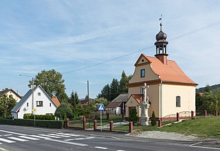
Święcko is a village in the administrative district of Gmina Kłodzko, within Kłodzko County, Lower Silesian Voivodeship, in south-western Poland. Prior to 1945 it was in Germany. It lies approximately 9 kilometres (6 mi) north-west of Kłodzko and 77 km (48 mi) south-west of the regional capital Wrocław.
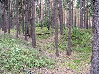
The Silesian Walls are a line of three parallel earthen ramparts and ditches that run through Lower Silesia in Poland, by the towns Szprotawa and Kożuchów. The walls are about 2.5 metres tall and, at their widest, 47 metres. They run for about 30 kilometres. It is hypothesized by Maciej Boryna of the Muzeum Ziemi Szprotawskiej that the Silesia Walls were the southwest border of the Duchy of Głogów and built in 1413-1467. It is possible that rather than being military in nature the walls were designed as a type of landwehr to reduce smuggling.
Lipowiec is a village in the administrative district of Gmina Zbiczno, within Brodnica County, Kuyavian-Pomeranian Voivodeship, in north-central Poland.
Stary Majdan is a village in the administrative district of Gmina Wojsławice, within Chełm County, Lublin Voivodeship, in eastern Poland. It lies approximately 5 kilometres (3 mi) south-west of Wojsławice, 28 km (17 mi) south of Chełm, and 76 km (47 mi) south-east of the regional capital Lublin.
Derhawka is a settlement in the administrative district of Gmina Czeremcha, within Hajnówka County, Podlaskie Voivodeship, in north-eastern Poland, close to the border with Belarus.
Psary Stare is a village in the administrative district of Gmina Wolbórz, within Piotrków County, Łódź Voivodeship, in central Poland.
Ruszków is a village in the administrative district of Gmina Brzeźnio, within Sieradz County, Łódź Voivodeship, in central Poland.
Sędzice is a village in the administrative district of Gmina Wróblew, within Sieradz County, Łódź Voivodeship, in central Poland. It lies approximately 4 kilometres (2 mi) north of Wróblew, 12 km (7 mi) north-west of Sieradz, and 62 km (39 mi) west of the regional capital Łódź.
Nowy Świat is a village in the administrative district of Gmina Wieluń, within Wieluń County, Łódź Voivodeship, in central Poland. It lies approximately 5 kilometres (3 mi) south of Wieluń and 90 km (56 mi) south-west of the regional capital Łódź.
Glinka is a village in the administrative district of Gmina Gnojno, within Busko County, Świętokrzyskie Voivodeship, in south-central Poland. It lies approximately 2 kilometres (1 mi) east of Gnojno, 18 km (11 mi) north-east of Busko-Zdrój, and 37 km (23 mi) south-east of the regional capital Kielce.
Droblin is a village in the administrative district of Gmina Wodzisław, within Jędrzejów County, Świętokrzyskie Voivodeship, in south-central Poland. It lies approximately 3 kilometres (2 mi) south-east of Wodzisław, 17 km (11 mi) south-west of Jędrzejów, and 52 km (32 mi) south-west of the regional capital Kielce.
Pasturka is a village in the administrative district of Gmina Pińczów, within Pińczów County, Świętokrzyskie Voivodeship, in south-central Poland. It lies approximately 5 kilometres (3 mi) south-east of Pińczów and 44 km (27 mi) south of the regional capital Kielce.
Forestowo is a village in the administrative district of Gmina Ostroróg, within Szamotuły County, Greater Poland Voivodeship, in west-central Poland.
Chełmno is a village in the administrative district of Gmina Pniewy, within Szamotuły County, Greater Poland Voivodeship, in west-central Poland. It lies approximately 5 kilometres (3 mi) south-east of Pniewy, 22 km (14 mi) south-west of Szamotuły, and 42 km (26 mi) west of the regional capital Poznań.
Sokolniki is a village in the administrative district of Gmina Niegowa, within Myszków County, Silesian Voivodeship, in southern Poland. It lies approximately 10 kilometres (6 mi) east of Niegowa, 28 km (17 mi) east of Myszków, and 70 km (43 mi) north-east of the regional capital Katowice.
Mieszków is a village in the administrative district of Gmina Trzebiel, within Żary County, Lubusz Voivodeship, in western Poland, close to the German border. It lies approximately 7 kilometres (4 mi) south-east of Trzebiel, 18 km (11 mi) west of Żary, and 58 km (36 mi) south-west of Zielona Góra.
Młyny is a village in the administrative district of Gmina Rudniki, within Olesno County, Opole Voivodeship, in south-western Poland. It lies approximately 2 kilometres (1 mi) north of Rudniki, 24 km (15 mi) north-east of Olesno, and 64 km (40 mi) north-east of the regional capital Opole.
Głębokie is a village in the administrative district of Gmina Pruszcz Gdański, within Gdańsk County, Pomeranian Voivodeship, in northern Poland. It lies approximately 4 kilometres (2 mi) north-west of Pruszcz Gdański and 9 km (6 mi) south of the regional capital Gdańsk.
Wycinki is a village in the administrative district of Gmina Osiek, within Starogard County, Pomeranian Voivodeship, in northern Poland. It lies approximately 2 kilometres (1 mi) south of Osiek, 29 km (18 mi) south of Starogard Gdański, and 74 km (46 mi) south of the regional capital Gdańsk.


