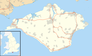
South Wight was a non-metropolitan district with the status of a borough on the Isle of Wight in England from 1974 to 1995.

The Isle of Wight Steam Railway is a heritage railway on the Isle of Wight. The railway passes through 5 1⁄2 miles (9 km) of unspoiled countryside from Smallbrook Junction to Wootton station, passing through the small village of Havenstreet, where the line has a station, headquarters and a depot. At Smallbrook Junction, the steam railway connects with the Island Line.

Whippingham is a village and civil parish on the Isle of Wight. The population of the Civil Parish at the 2011 Census was 787. It is located 1 1⁄2 miles (2.4 km) south of East Cowes in the north of the Island.

Foreland or Forelands, and the adjacent Foreland Fields, is the easternmost point of the Isle of Wight, part of the village of Bembridge. It is located about 6.5 miles due south of the city of Portsmouth on the British mainland, separated by the eastern reaches of the Solent. It is characterised by a pub called the Crab and Lobster Inn and various beach huts plus a beach cafe and a coast guard lookout. In the sea are the reefs of Bembridge Ledge which is rich in edible crabs, lobsters and spider crabs and shoals of mackerel. In the Crab & Lobster Inn are photographs of the many shipwrecks, which included the submarine HMS Alliance, now a museum ship at Gosport and the First World War troopship the S.S. Mehndi carrying troops from South Africa, with great loss of life.
Little Atherfield is a small settlement on the Isle of Wight. It is near the coast in the Back of the Wight. The Isle of Wight is situated off the south coast of England. According to the Post Office the 2011 Census population of the village was listed in the civil parish of Niton and Whitwell.

Whiteley Bank, also spelled "Whitely Bank", is a small village or hamlet on the Isle of Wight, United Kingdom. It is located two miles west of Shanklin and five and a half miles (8.9 km) south-east of Newport. It is mainly known by the crossroads, now styled as a mini-roundabout, between the A3020, B3327 and Canteen Road to Apse Heath. Whiteley Bank is in Newchurch Parish.

Shide is a small settlement on the Isle of Wight, some of which is considered to be in the Newport conurbation.

Winford is a hamlet on the Isle of Wight, that since the 1950s and in particular in the late 1970s has seen considerable housing development. The local shop in Forest Road closed some time ago, but tourist attractions with gift shops are situated nearby. It is in the civil parish of Newchurch.

Nettlecombe is a farming hamlet on the Isle of Wight. It is the site of a deserted medieval village and there is evidence of earthworks close to the present hamlet. There are several fishing lakes in Nettlecombe.
Borthwood is a hamlet on the Isle of Wight, adjacent to Borthwood Copse, the National Trust woodland. Borthwood includes some holiday cottages and a pet kennel. At the 2011 Census the Post Office specified that the population of the hamlet was included in the civil parish of Newchurch, Isle of Wight.

Sandford is a hamlet on the Isle of Wight. Sandford is on the outskirts of Godshill in the southeast part of the island. Sandford has a latitude of 50°37′48.23″N1°13′45.63″W. Sandford is located on the A 3020 road and public transport is provided by bus route 2 and 3, run by Southern Vectis.

Bierley is a hamlet on the Isle of Wight, UK. Bierley is in the south of the Isle of Wight, north of Niton and 0.7 miles to the west of Whitwell. Bierley is at the corner of Kingates Lane and Newport Road.

Staplers is a suburb of Newport, Isle of Wight, England, on the east side of the River Medina.
Hale Common is a farming hamlet on the Isle of Wight. Hale Common is on the A3056 road between Lake and Arreton. Hale Common is northeast of Bathingbourne and northwest of Branstone. It is in the civil parish of Godshill.

Pondwell is an area of the Isle of Wight between Nettlestone and Ryde. According to the Post Office the population for the area at the 2011 Census was included in the civil parish of Nettlestone and Seaview. The houses are arranged to the south east of a crossroads known as Bullen Cross, which features a vintage electricity junction box from a 19th-century local power generating company. Known as a "supply pillar" it features a once-plentiful "batwing" lantern manufactured by Electric Street Lighting Apparatus (ESLA) of Canterbury. Pondwell is also the site of Seaview Wildlife Encounter — formerly Flamingo Park, a small zoo and waterfowl park. There is also a pub called the "Wishing Well". It also offers holiday chalets at the Salterns and a nail technician, mortgage broker and the chair of the IOW Table Tennis Association. The beach at the bottom of the Salterns was formerly a thriving harbour for timber export; at that time the low-lying land at the foot of Pondwell Hill formed a tidal inlet of the sea known as Barnsley Creek.

All Saints' Church, Freshwater is a parish church in the Church of England located in Freshwater, Isle of Wight.
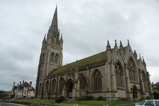
All Saints' Church, Ryde is a parish church in the Church of England located in Ryde, Isle of Wight. The building is a landmark of the Island, the spire being visible from many places around the Isle of Wight - and indeed from the mainland - projecting beyond the skyline. All Saints' is sometimes referred to as the "Cathedral of the Island" It is a Grade II* ecclesiatical listed building.

The Church of St. Mary and St. Radegund, Whitwell is a parish church in the Church of England located in Whitwell on the Isle of Wight.

Carisbrooke Priory was an alien priory, a dependency of Lyre Abbey in Normandy. The priory was situated on rising ground on the outskirts of Carisbrooke close to Newport on the Isle of Wight.