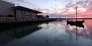
Geraldton is a coastal city in the Mid West region of Western Australia, 424 kilometres (263 mi) north of the state capital, Perth.

The Adelaide–Darwin railway line is a railway line in Australia, between the South Australian town of Tarcoola and the Northern Territory city of Darwin. Preceded by a number of other shorter railways, a line through to Darwin was fully realised in 2004 when the final link from Alice Springs to Darwin was opened. Forming the main section of the 2,975 kilometres (1,849 mi) rail corridor between the cities of Adelaide and Darwin, the line is used by The Ghan passenger train and interstate freight trains operated by Aurizon.
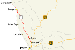
Brand Highway is a 370-kilometre (230 mi) main highway linking the northern outskirts of Perth to Geraldton in Western Australia. Together with North West Coastal Highway, it forms part of the Western Australian coastal link to the Northern Territory. The highway is a part of Australia's Highway 1, and is for the most part a single carriageway with one lane in each direction.
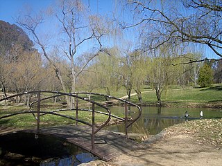
Weston Park is a park located on a peninsula on the western side of Lake Burley Griffin in Canberra, Australia. In 1963 the park was named after Charles Weston, who had founded the nearby Yarralumla Nursery in 1914. On the western side of the peninsula is Yarramundi Reach and on the eastern side is Tarcoola Reach. The end of the peninsula is called Kurrajong Point.

Tarcoola railway station is a railway station in the Australian state of South Australia located on the Trans-Australian Railway in the state's west. It serves the town of Tarcoola and is the northern junction of the Sydney-Perth and Adelaide-Darwin railways, which share approximately 530 kilometres (329 mi) of track between Tarcoola and Crystal Brook.
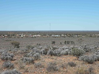
Tarcoola is a town in the Far North of South Australia 416 kilometres (258 mi) north-northwest of Port Augusta. At the 2016 census, Tarcoola had no people living within its boundaries.

Geraldton Airport is an airport located 6 nautical miles east of Geraldton, Western Australia, in Moonyoonooka along the Geraldton – Mount Magnet Road.

The City of Geraldton was a local government area in the Mid West region of Western Australia, 424 kilometres (263 mi) north of the state capital, Perth on the Indian Ocean. The City covered an area of 46.3 square kilometres (17.9 sq mi), and its seat of government was the town of Geraldton.
The Shire of Greenough was a local government area in the Mid West region of Western Australia, 420 kilometres (261 mi) north of the state capital, Perth surrounding the city of Geraldton. The Shire covered an area of 1,752 square kilometres (676.5 sq mi), and its seat of government was the outer Geraldton suburb of Utakarra.
The City of Geraldton-Greenough was a local government area in the Mid West region of Western Australia, 424 kilometres (263 mi) north of the state capital, Perth on the Indian Ocean. It covered an area of 1,798.3 square kilometres (694.3 sq mi), and its seat of government was the town of Geraldton.
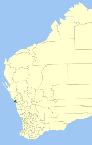
Tarcoola Beach is a southern coastal suburb of Geraldton, Western Australia, which falls under the jurisdiction of the local government area of the City of Greater Geraldton.
Beachlands is an inner western suburb of Geraldton, Western Australia in the local government area of the City of Greater Geraldton.
Drummond Cove is a coastal town located 12 kilometres (7 mi) north of Geraldton, Western Australia in the local government area of the City of Greater Geraldton. The locality was gazetted in 1985.
West End is a western suburb of Geraldton, Western Australia. Its local government area is the City of Greater Geraldton.
Wandina is an outer southern suburb of Geraldton, Western Australia. Its local government area is the City of Greater Geraldton.
Mount Tarcoola is a southern suburb of Geraldton, Western Australia. Its local government area is the City of Greater Geraldton.
Sunset Beach is an outer northern coastal suburb of Geraldton, Western Australia. Its local government area is the City of Greater Geraldton.

The City of Greater Geraldton is a local government area in the Mid West region of Western Australia, 424 kilometres (263 mi) north of the state capital, Perth on the Indian Ocean. It covers an area of 12,625.5 square kilometres (4,874.7 sq mi), and its seat of government is the town of Geraldton.
Balline Station is a pastoral lease that operates as a sheep station in Western Australia.
Tarcoola is a town in South Australia.