
The Muckleshoot are a Lushootseed-speaking Native American tribe, part of the Coast Salish peoples of the Pacific Northwest. They are descendants of the Duwamish peoples whose traditional territory was located along the Green and White rivers, including up to the headwaters in the foothills of the Cascade Mountains, in present-day Washington State. Since the mid-19th century, their reservation is located in the area of Auburn, Washington, about 15 miles (24 km) northeast of Tacoma and 35 miles (56 km) southeast of Seattle.
The Squaxin Island Tribe are the descendants of several Lushootseed clans organized under the Squaxin Island Indian Reservation, a Native American tribal government in western Washington state.

The Tulalip Tribes of Washington, formerly known as the Tulalip Tribes of the Tulalip Reservation, is a federally recognized tribe of Duwamish, Snohomish, Snoqualmie, Skagit, Suiattle, Samish, and Stillaguamish people. They are South and Central Coast Salish peoples of indigenous peoples of the Pacific Northwest Coast. Their tribes are located in the mid-Puget Sound region of Washington.

The Swinomishpeople are a Lushootseed-speaking people Indigenous to western Washington state.

The Modoc are an Indigenous American people who historically lived in the area which is now northeastern California and central Southern Oregon. Currently, they include two federally recognized tribes, the Klamath Tribes in Oregon and the Modoc Tribe of Oklahoma, now known as the Modoc Nation.
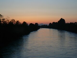
The Puyallup River is a river in the U.S. state of Washington. About 45 miles (72 km) long, it is formed by glaciers on the west side of Mount Rainier. It flows generally northwest, emptying into Commencement Bay, part of Puget Sound. The river and its tributaries drain an area of about 948 square miles (2,460 km2) in Pierce County and southern King County.
The Indian Shaker Church is a Christian denomination founded in 1881 by Squaxin shaman John Slocum and his wife Mary Slocum in Washington state. The Indian Shaker Church is a unique blend of Indigenous, Catholic, and Protestant beliefs and practices.
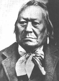
Squ-sacht-un, also known as John Slocum, was a member of the Squaxin Island Tribe, Coast Salish, and a reputed holy man and prophet who founded the Indian Shaker Church in 1881.

The Puget Sound War was an armed conflict that took place in the Puget Sound area of the state of Washington in 1855–56, between the United States military, local militias and members of the Native American tribes of the Nisqually, Muckleshoot, Puyallup, and Klickitat. Another component of the war, however, were raiders from the Haida and Tlingit who came into conflict with the United States Navy during contemporaneous raids on the native peoples of Puget Sound. Although limited in its magnitude, territorial impact and losses in terms of lives, the conflict is often remembered in connection to the 1856 Battle of Seattle and to the execution of a central figure of the war, Nisqually Chief Leschi. The contemporaneous Yakima War may have been responsible for some events of the Puget Sound War, such as the Battle of Seattle, and it is not clear that the people of the time made a strong distinction between the two conflicts.
Chief Moses was a Native American chief of the Sinkiuse-Columbia, in what is now Washington state. The territory of his tribe extended approximately from Waterville to White Bluffs, in the Columbia Basin. They were often in the area around Moses Lake. The tribe numbered perhaps a few hundred individuals.
The Lower Skagit are a tribe of the Lushootseed Native American people living in the U.S. state of Washington. Today they are enrolled in the federally recognized tribe, the Swinomish Indians of the Swinomish Reservation.
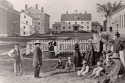
Watervliet Shaker Historic District, in Colonie, New York, is the site of the first Shaker community, established in 1776. The primary Shaker community, the Mount Lebanon Shaker Society, was started a bit later. Watervliet's historic 1848 Shaker meetinghouse has been restored and is used for public events, such as concerts.

Billy Frank Jr. was a Native American environmental leader and advocate of treaty rights. As a member of the Nisqually tribe, Frank led a grassroots campaign in the 1960s and 1970s to secure fishing rights on the Nisqually River, located in Washington state. His efforts centered around promoting cooperative management of natural resources. Frank served as the chairman of the Northwest Indian Fisheries Commission for over thirty years.

Donegal Presbyterian Church Complex is an historic Presbyterian church complex on Donegal Springs Road in East Donegal Township, Lancaster County, Pennsylvania. The church was built in 1732, and is a 1+1⁄2-story, three-bay-by-five bay, stuccoed stone building with a gambrel roof.
Mud Bay is the southernmost reach of Puget Sound, at Eld Inlet just outside the city limits of Olympia, Washington. The name Eld Inlet was officially bestowed after a member of the U.S. Navy's Wilkes Expedition, but "Mud Bay" is a local, informal adoption.
The Steilacoompeople are Lushootseed-speaking Southern Coast Salish people, indigenous to the southern Puget Sound region of Washington state.

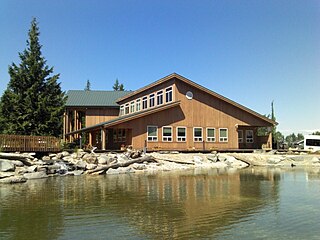
Mud Bay Indian Shaker Church is the first church built by the Indian Shaker Church.

South Puget Sound is the southern reaches of Puget Sound in Southwest Washington, in the United States' Pacific Northwest. It is one of five major basins encompassing the entire Sound, and the shallowest basin, with a mean depth of 37 meters (121 ft). Exact definitions of the region vary: the state's Department of Fish and Wildlife counts all of Puget Sound south of the Tacoma Narrows for fishing regulatory purposes. The same agency counts Mason, Jefferson, Kitsap, Pierce and Thurston Counties for wildlife management. The state's Department of Ecology defines a similar area south of Colvos Passage.

