Related Research Articles

Agathis australis, commonly known by its Māori name kauri, is a coniferous tree in the family Araucariaceae, found north of 38°S in the northern regions of New Zealand's North Island.

The Northland Region is the northernmost of New Zealand's 16 local government regions. New Zealanders sometimes refer to it as the Winterless North because of its mild climate all throughout the year. The main population centre is the city of Whangārei, and the largest town is Kerikeri. At the 2018 New Zealand census, Northland recorded a surprising population growth spurt of 18.1% since the previous 2013 census, placing it as the fastest growing region in New Zealand, ahead of other strong growth regions such as the Bay of Plenty and Waikato.
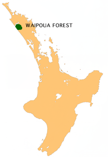
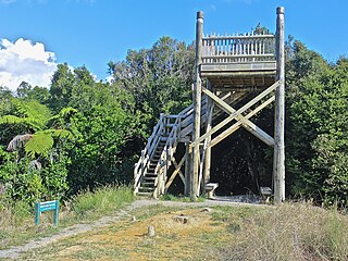
Waipoua Forest is a forest, on the west coast of the Northland Region of New Zealand's North Island. It preserves some of the best examples of kauri forest remaining in New Zealand. It is notable for having two of the largest living kauri trees, Tāne Mahuta and Te Matua Ngahere.
Hakarimata Range is a range of hills on the western edge of Ngāruawāhia township, in the Waikato region of New Zealand, overlooking the confluence of the Waikato and Waipa Rivers. The Hakarimata Range is separated from the Taupiri Range by the Taupiri Gorge, through which the Waikato River flows.

The Waitākere Ranges is a mountain range in New Zealand. Located between metropolitan Auckland and the west coast of the former Waitakere City and Rodney District, the ranges and its foothills and coasts comprise some 27,720 hectares of public and private land. The area, traditionally known to Māori as Te Wao Nui o Tiriwa, is of local, regional, and national significance. The Waitākere Ranges includes a chain of hills in the Auckland Region, generally running approximately 25 kilometres (16 mi) from north to south, 25 km west of central Auckland. The ranges are part of the Waitākere Ranges Regional Park.

The Hunua Ranges is a mountain range and regional park to the southeast of Auckland, in Franklin in the Auckland Region of New Zealand's North Island. The ranges cover some 250 square kilometres (97 sq mi) and rise to 688 metres (2255 ft) at Kohukohunui.

Karekare is a small coastal settlement in the Auckland Region of northern New Zealand, sandwiched between the Waitākere Ranges and a large black sand surf beach.
Tāne Mahuta, also called "God of the Forest", is a giant kauri tree in the Waipoua Forest of Northland Region, New Zealand. Its age is unknown but is estimated to be between 1,250 and 2,500 years. It is the largest living kauri tree known to stand today. It is named for the Māori god of forests and of birds.

Te Matua Ngahere is a giant kauri coniferous tree in the Waipoua Forest of Northland Region, New Zealand. The tree's Māori name means "Father of the Forest". Although not as massive or tall as its neighbour Tāne Mahuta, Te Matua Ngahere is stouter, with a girth just over 16 metres (52 ft). It is believed to be the second largest living kauri tree, and to have the biggest girth of any kauri in the country. According to The New Zealand Herald, it has the biggest girth of any tree in New Zealand.
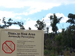
Phytophthora cinnamomi is a soil-borne water mould that produces an infection which causes a condition in plants variously called "root rot", "dieback", or, "ink disease". The plant pathogen is one of the world's most invasive species and is present in over 70 countries around the world.

Scenic Drive is a road that runs through the bush-clad Waitākere Ranges from Titirangi to Swanson on the western outskirts of Auckland, New Zealand. It is part of Auckland urban route 24. As the name indicates, it is famous for the sweeping views over the western parts of the Auckland Region.
The Maungataniwha Range is a volcanic mountain range located in Northland Region of New Zealand. The Mangamukas, as it is known by the local residents and many Northlanders because of the name of the settlement and river on the southern side, separates Kaitaia and the Aupouri Peninsula from the rest of Northland. The highest point in the Maungataniwha Ranges is Raetea at 744m. The range is home to many kauri trees and part of the range is a part of Northland Forest Park.
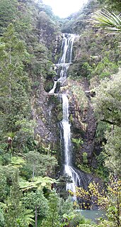
Kitekite Falls is a scenic 3-tiered waterfall near Auckland, New Zealand. The falls drop a total of 40 metres (130 ft). From the lookout on Kitekite track the falls appear even higher because there is white water running over rocks into a small pool from the upper swimming hole, then falling down into a large pool, then falling to a small pool before beginning an almost vertical descent in the final 3-tiers, making the total height closer to 80 metres (260 ft). They are located on the Glen Esk stream near Piha Beach.

The Northland temperate kauri forests is an ecoregion in northern New Zealand, within the temperate broadleaf and mixed forests biome.

Le Roys Bush is a public reserve between Birkenhead and Northcote in Auckland, New Zealand.

Kauri dieback is a forest dieback disease of the native kauri trees of New Zealand that is suspected to be caused by the oomycete Phytophthora agathidicida. Symptoms can include root rot and associated rot in a collar around the base of the tree, bleeding resin, yellowing and chlorosis of the leaves followed by extensive defoliation, and finally, death.
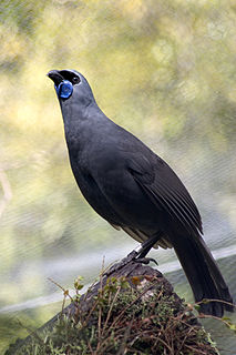
The North Island kōkako is an endangered forest bird which is endemic to the North Island of New Zealand. It is grey in colour, with a small black mask. It has blue wattles. Because of its wattle, the bird is sometimes locally called the blue-wattled crow, although it is not a corvid.

Trounson Kauri Park is a mainland island in the Northland Region of New Zealand. Characterised by its Kauri trees, it was named after James Trounson, who gifted the forest to the Department of Conservation.

Aotea Conservation Park is a 12,300 hectare protected area on Great Barrier Island in New Zealand's Hauraki Gulf. It was established in 2015, and comprises 43 percent of the island.

Mokoroa Falls is a waterfall located between Muriwai and the Waitakere Ranges in Auckland’s west coast in New Zealand.