Related Research Articles

The Murrumbidgee River is a major tributary of the Murray River within the Murray–Darling basin and the second longest river in Australia. It flows through the Australian state of New South Wales and the Australian Capital Territory, descending 1,500 metres (4,900 ft) over 1,485 kilometres (923 mi), generally in a west-northwesterly direction from the foot of Peppercorn Hill in the Fiery Range of the Snowy Mountains towards its confluence with the Murray River near Boundary Bend.

Newell Highway is a national highway in New South Wales (NSW), Australia. It provides the major road link between southeastern Queensland and Victoria via central NSW and as such carries large amounts of freight. At 1,058 kilometres (657 mi) in length, the Newell is the longest highway in NSW, and passes through fifteen local government areas.

Balranald is a town within the local government area of Balranald Shire, in the Murray region of far south-western New South Wales, Australia.

Sturt Highway is an Australian national highway in New South Wales, Victoria, and South Australia. It is an important road link for the transport of passengers and freight between Sydney and Adelaide and the regions along the route.

Hay is a town in the western Riverina region of south western New South Wales, Australia. It is the administrative centre of Hay Shire local government area and the centre of a prosperous and productive agricultural district on the wide Hay Plains.

Cobb Highway is a state highway in the western Riverina and the far western regions of New South Wales, with a short section in Victoria, Australia, designated part of route B75.
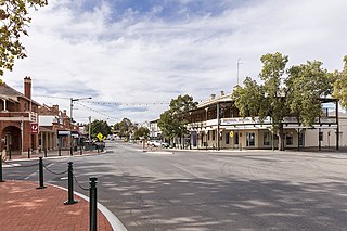
Narrandera, until around 1949 also spelled "Narandera", is a town located in the Riverina region of south-western New South Wales, Australia. The town lies on the junction of the Newell and Sturt highways, adjacent to the Murrumbidgee River, and it is considered the gateway to the Murrumbidgee Irrigation Area. At the 2016 census, Narrandera had a population of 3746 people.

Gundagai is a town in New South Wales, Australia. Although a small town, Gundagai is a popular topic for writers and has become a representative icon of a typical Australian country town. Located along the Murrumbidgee River and Muniong, Honeysuckle, Kimo, Mooney Mooney, Murrumbidgee and Tumut mountain ranges, Gundagai is 390 kilometres (240 mi) south-west of Sydney. Until 2016, Gundagai was the administrative centre of Gundagai Shire local government area. In the 2021 census, the population of Gundagai was 2,057.

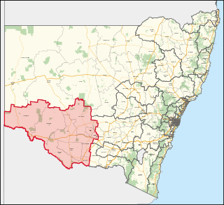
The Riverina is an agricultural region of southwestern New South Wales, Australia. The Riverina is distinguished from other Australian regions by the combination of flat plains, warm to hot climate and an ample supply of water for irrigation. This combination has allowed the Riverina to develop into one of the most productive and agriculturally diverse areas of Australia. Bordered on the south by the state of Victoria and on the east by the Great Dividing Range, the Riverina covers those areas of New South Wales in the Murray and Murrumbidgee drainage zones to their confluence in the west.

Darlington Point is a small town on the banks of the Murrumbidgee River in the central Riverina district of western New South Wales, Australia. It is part of the Murrumbidgee Council local government area. The centre of town is four kilometres from the Sturt Highway, along Kidman Way. Darlington Point is 631 kilometres (392 mi) south-west of Sydney and 33 kilometres (21 mi) south of Griffith. At the 2021 census, Darlington Point had a population of 1,030.
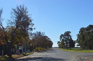
Maude is a village on the north bank of the Murrumbidgee River in New South Wales, Australia. It is in between Hay and Balranald in Hay Shire. It is 55 kilometres downstream from Hay and 25 kilometres upstream from the junction of the Lachlan River with the Murrumbidgee. At the 2006 census, it had a population of 161. It consists of a general store, hotel, post office and caravan park. It is surrounded by market gardens supplied with water from Maude Weir, a popular spot for anglers looking for yellow belly, redfin and Murray cod.

Oxley is a community on the lower Lachlan River in the Riverina district of New South Wales, Australia near the junction of the Lachlan and Murrumbidgee Rivers. The township which developed in the mid-1860s was named after the noted Australian explorer, John Oxley. At the 2006 census, Oxley had a population of 159 people.

The Nari-Nari are an Indigenous Australian group in the Riverina region of New South Wales, Australia. The Nari-Nari are believed by historians to have formed in the Balranald area on the lower Murrumbidgee River, from the amalgamation of a number of groups in neighbouring areas such as the Wiradjuri and the Watiwati. The Nari-Nari share a western border with the Muthi Muthi tribe.
Murray is an electoral district in the Australian state of New South Wales.
The Hay Standard was an English language newspaper published in Hay, New South Wales, from 1871 to 1900. It was the first newspaper published at Hay.

Murrumbidgee River railway bridge is a heritage-listed disused railway bridge on the Tocumwal railway line crossing from Narrandera to Gillenbah, both in Narrandera Shire, New South Wales, Australia. It was designed by John Whitton in his capacity as Engineer-in-Chief for Railways, and built in 1884–85 by Halliday & Owen with ironwork supplied by English firm Westwood, Baillie. It is also known as Narrandera Lattice Railway Bridge. The property was added to the New South Wales State Heritage Register on 2 April 1999 and was added to the Register of the National Estate on 15 May 1990.
The Cumbung Swamp, also known as the Great Cumbung Swamp, is a wetland made up of the ecosystems surrounding the junction of the Murrumbidgee and Lachlan Rivers in the South West Region of New South Wales. When it is at full capacity, the swamp supports a large population of migratory waterbirds as well as one of the largest reed swamps in the Murray Darling Basin.

The Hay Bridge is a road bridge that carries the Cobb Highway across the Murrumbidgee River at Hay, New South Wales, Australia. The current bridge is the second bridge located in Hay that crosses the Murrumbidgee; the first bridge was in operation from 1873 until 1973; the second and current bridge has operated since 1973.
References
- ↑ Estimated by adding 207 miles to Narrandera's value
- ↑ Estimated by adding 125 miles to Narrandera's value
- ↑ Estimated by adding 75 miles to Narrandera's value
- ↑ Distance from Hay to Murray River junction has been estimated by adding 82 river miles to Balranald's value.
- ↑ "-Murray Lands and their Prospects". The Border Watch . Mount Gambier, SA. 16 December 1908. p. 4. Retrieved 19 September 2015– via National Library of Australia. Distance from Hay to river mouth (past Goolwa) has been estimated by adding 850 river miles to Balranald's value.
- ↑ "The Murrumbidgee". The Riverine Grazier . Hay, NSW. 7 March 1933. p. 3. Retrieved 18 September 2015– via National Library of Australia.