Related Research Articles

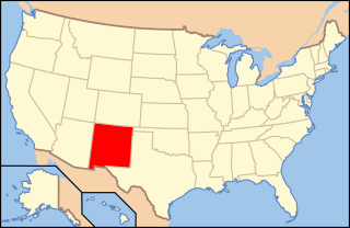
Albuquerque, abbreviated ABQ, is the most populous city in the U.S. state of New Mexico. Its nicknames, The Duke City and Burque, both reference its founding in 1706 as La Villa de Alburquerque by Nuevo México governor Francisco Cuervo y Valdés. Named in honor of the Viceroy of New Spain, the 10th Duke of Alburquerque, the city was an outpost on El Camino Real linking Mexico City to the northernmost territories of New Spain. In 2006 the city celebrated its 300th anniversary.

The Southwestern United States, also known as the American Southwest or simply the Southwest, is a geographic and cultural region of the United States that includes Arizona and New Mexico, along with adjacent portions of California, Colorado, Nevada, Oklahoma, Texas, and Utah. The largest cities by metropolitan area are Phoenix, Las Vegas, El Paso, Albuquerque, and Tucson. Before 1848, in the historical region of Santa Fe de Nuevo México as well as parts of Alta California and Coahuila y Tejas, settlement was almost non-existent outside of Nuevo México's Pueblos and Spanish or Mexican municipalities. Much of the area had been a part of New Spain and Mexico until the United States acquired the area through the Treaty of Guadalupe Hidalgo in 1848 and the smaller Gadsden Purchase in 1854.
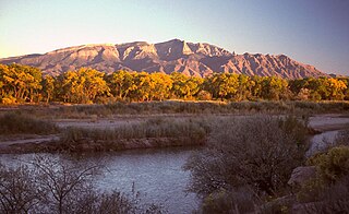
The Sandia Mountains are a mountain range located in Bernalillo and Sandoval counties, immediately to the east of the city of Albuquerque in New Mexico in the southwestern United States. The mountains are just due south of the southern terminus of the Rocky Mountains, and are part of the Sandia–Manzano Mountains. This is largely within the Cibola National Forest and protected as the Sandia Mountain Wilderness. The highest point is Sandia Crest, 10,678 feet (3,255 m).

The Sangre de Cristo Mountains are the southernmost subrange of the Rocky Mountains. They are located in southern Colorado and northern New Mexico in the United States. The mountains run from Poncha Pass in South-Central Colorado, trending southeast and south, ending at Glorieta Pass, southeast of Santa Fe, New Mexico. The mountains contain a number of fourteen thousand foot peaks in the Colorado portion, as well as all the peaks in New Mexico which are over twelve thousand feet.
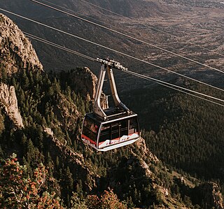
The Sandia Peak Tramway is an aerial tramway located adjacent to Albuquerque, New Mexico. It stretches from the northeast edge of the city to Sandia Peak on the ridge line of the Sandia Mountains and has the world's third longest single span. It is the longest aerial tram in the Americas, and was the longest in the world from 1966 until being surpassed in 2010 by the Wings of Tatev in Armenia.

The Cibola National Forest is a 1,633,783 acre United States National Forest in New Mexico, USA. The name Cibola is thought to be the original Zuni Indian name for their pueblos or tribal lands. The name was later interpreted by the Spanish to mean "buffalo." The forest is disjointed with lands spread across central and northern New Mexico, west Texas and Oklahoma. The Cibola National Forest is divided into four Ranger Districts: the Sandia, Mountainair, Mt. Taylor, and Magdalena. The Forest includes the San Mateo, Magdalena, Datil, Bear, Gallina, Manzano, Sandia, Mt. Taylor, and Zuni Mountains of west-central New Mexico. The Forest also manages four National Grasslands that stretch from northeastern New Mexico eastward into the Texas Panhandle and western Oklahoma. The Cibola National Forest and Grassland is administered by Region 3 of the United States Forest Service from offices in Albuquerque, New Mexico. Elevation ranges from 5,000 ft to 11,301 ft. The descending order of Cibola National Forest acres by county are: Socorro, Cibola, McKinley, Catron, Torrance, Bernalillo, Sandoval County, New Mexico, Lincoln, Sierra, and Valencia counties in New Mexico. The Cibola National Forest currently has 137,701 acres designated as Wilderness. In addition to these acres, it has 246,000 acres classified as Inventoried Roadless Areas pursuant to the Roadless Area Conservation Rule.

The Sierra Blanca is an ultra-prominent range of volcanic mountains in Lincoln and Otero counties in the south-central part of the U.S. state of New Mexico. The range is about 40 miles (64 km) from north to south and 20 miles (32 km) wide.

Sandia Pueblo is a federally recognized tribe of Native American Pueblo people inhabiting a 101-square-kilometre (40 sq mi) reservation of the same name in the eastern Rio Grande Rift of central New Mexico. It is one of 19 of New Mexico's Native American pueblos, considered one of the state's Eastern Pueblos. The population was 427 as of the 2010 census. The people are traditionally Tiwa speakers, a language of the Tanoan group, although retention of the traditional language has waned with later generations. They have a tribal government that operates Sandia Casino, Bien Mur Indian Market Center, and Sandia Lakes Recreation Area, as well as representing the will of the Pueblo in business and political matters.

Carson National Forest is a national forest in northern New Mexico, United States. It encompasses 6,070 square kilometers and is administered by the United States Forest Service. The Forest Service's "mixed use" policy allows for its use for recreation, grazing, and resource extraction.

Sandia Crest, also known locally as Sandia Peak or simply as the Crest, is a mountain ridge that, at 10,679 feet (3,255 m), is the highpoint of the Sandia–Manzano Mountains, and is located in the Sandia Mountains of Bernalillo County, New Mexico, United States. Instead of a true summit or topographic peak, this range climbs to a long ridge line. To the east, the range slopes down from the Crest and merges into the plains below. On the west side of the Crest is a cliff; the range dramatically drops over 4,000 feet in elevation over 2 miles of horizontal distance to the Rio Grande Valley and city of Albuquerque below. It is within the Sandia Ranger District of the Cibola National Forest. The Crest features a viewing area with a shop and visitor center, telecommunications transmitters, the popular La Luz Trail, the Sandia Mountain Wilderness, and the summit of Sandia Peak Ski Area and the Sandia Peak Tramway, which is the longest aerial tramway in the Americas.
The following is an alphabetical list of articles related to the U.S. state of New Mexico.
Sandia Peak may refer to:

Enoch Steen was a United States military officer and western explorer. He joined the United States Army in 1832, serving at posts throughout the United States, including many remote locations in the west. During his military service, Steen explored parts of the western United States including large areas of southern New Mexico and southeastern Oregon. He served as the commander of several Union Army forts during the American Civil War. Today, there are landmarks in Oklahoma, Oregon, and New Mexico named in his honor; however, many of the place names are misspelled as Stein.

The Enchanted Circle Scenic Byway is a New Mexico Scenic Byway and National Forest Scenic Byway located in Northern New Mexico. It begins and ends in Taos, New Mexico.

The Indigenous peoples of the North American Southwest are those in the current states of Colorado, Arizona, New Mexico, Utah, and Nevada in the western United States, and the states of Sonora and Chihuahua in northern Mexico. An often quoted statement from Erik Reed (1964) defined the Greater Southwest culture area as extending north to south from Durango, Mexico to Durango, Colorado and east to west from Las Vegas, Nevada to Las Vegas, New Mexico. Other names sometimes used to define the region include "American Southwest", "Northern Mexico", "Chichimeca", and "Oasisamerica/Aridoamerica". This region has long been occupied by hunter-gatherers and agricultural people.

Sandia Peak Ski Area, originally La Madera Ski Area, is a ski resort located in the Sandia Mountains in northeast Bernalillo County, New Mexico, United States, immediately northeast of the city of Albuquerque. It is part of a Special Use Permit Zone in the Sandia Ranger District of the Cibola National Forest. It is New Mexico's first ski area, opening to skiers in 1936. It features Sandia Peak Tramway, which was until 2010 the longest tramway in the world, and remains the longest in the Americas. The resort includes 35 ski runs and a terrain park, and also serves as a site for summer recreation. It is one of the few ski resorts in the US that can be directly accessed from a major city.

Ski Santa Fe or Santa Fe Ski Basin is a medium-sized ski resort located in the Sangre de Cristo Mountains in Santa Fe County, New Mexico, United States, 16 miles east of the state capital of Santa Fe. It includes 7 lifts and 68 runs at elevations of over 10,000 feet (3,000 m). It is the southernmost major ski resort of the Rocky Mountains, and one of the oldest and highest in the nation.
World-class ski resorts located in the Southwestern state of New Mexico includes the southernmost major ski resort in the United States, as well as the longest aerial tramway in the Americas. The following table is comparison of their various sizes, runs, lifts, and snowfall:
References
- ↑ Gibson, Daniel & Blackwood, Jay (2021) Skiing in New Mexico Arcadia ISBN 9781467107020
- ↑ "Ski Resorts: Years They Were Founded". International Skiing History Association. Retrieved March 4, 2021.
- ↑ Gibson, Daniel (January 7, 2009). "Skiing through history at the state museum". Santa Fe New Mexican. Retrieved March 4, 2021.
- ↑ "History". New Mexico Ski Hall of Fame. Retrieved March 6, 2021.
- ↑ "History of SPSP". Sandia Peak Ski Patrol. Retrieved March 4, 2021.