This article needs additional citations for verification .(May 2021) |

Following is a list of stations of the Metro of Tunis , the light rail serving the city of Tunis.
This article needs additional citations for verification .(May 2021) |
Following is a list of stations of the Metro of Tunis , the light rail serving the city of Tunis.
Line 1 opened in 1985.
| Line | Stations [1] | Geographical coordinates | Delegation | P+R | Correspondences | |
|---|---|---|---|---|---|---|
| ■ | Place de Barcelone | 36°47′46″N10°10′50″E / 36.79607°N 10.18053°E | Bab el Bhar | | ||
| • | Bab Alioua | 36°47′09″N10°10′47″E / 36.78576°N 10.17982°E | Sidi el Béchir | | ||
| • | Mohamed-Manachou | 36°46′56″N10°10′47″E / 36.78210°N 10.17984°E | Sidi el Béchir | | ||
| • | 13-Août | 36°46′30″N10°10′45″E / 36.77506°N 10.17920°E | Sidi el Béchir | | ||
| • | Mohamed Ali | 36°46′04″N10°11′02″E / 36.76790°N 10.18386°E | El Ouardia | | ||
| • | El Kabaria | 36°45′35″N10°11′26″E / 36.75986°N 10.19055°E | El Kabaria | |||
| • | Ibn Sina | 36°45′15″N10°11′38″E / 36.75429°N 10.19395°E | El Kabaria | |||
| • | El Ouardia VI | 36°45′15″N10°11′57″E / 36.75422°N 10.19907°E | El Kabaria | |||
| • | Cité Ennour | 36°45′05″N10°12′17″E / 36.75147°N 10.20471°E | El Kabaria | |||
| • | Abou El Kacem Echebbi | 36°45′09″N10°12′53″E / 36.75243°N 10.21474°E | Ben Arous | |||
| ■ | Ben Arous | 36°45′20″N10°13′13″E / 36.75548°N 10.22022°E | Ben Arous |
Line 2 opened in 1989.
| Line | Stations | Geographical coordinates | Delegation | P+R | Correspondences | |
|---|---|---|---|---|---|---|
| ■ | Place de la République | 36°48′23″N10°10′51″E / 36.80648°N 10.18082°E | Bab el Bhar | | ||
| • | Nelson-Mandela | 36°48′40″N10°10′57″E / 36.81112°N 10.18256°E | Bab el Bhar | |||
| • | Mohammed-V | 36°48′57″N10°11′00″E / 36.81595°N 10.18321°E | Bab el Bhar | |||
| • | Place de Palestine | 36°49′09″N10°10′52″E / 36.81910°N 10.18099°E | Cité El Khadra | |||
| • | Les Jardins | 36°49′24″N10°11′08″E / 36.82342°N 10.18555°E | Cité El Khadra | |||
| • | Cité El Khadra | 36°49′45″N10°11′25″E / 36.82925°N 10.19037°E | Cité El Khadra | |||
| • | La Jeunesse | 36°50′00″N10°10′58″E / 36.83332°N 10.18276°E | Cité El Khadra | |||
| • | Cité sportive | 36°50′19″N10°10′55″E / 36.83850°N 10.18200°E | El Menzah | |||
| • | 10-Décembre-1984 | 36°50′40″N10°11′04″E / 36.84438°N 10.18431°E | Cité El Khadra | |||
| • | Cité des sciences (El Fell) [2] | 36°50′49″N10°11′33″E / 36.84698°N 10.19237°E | Cité El Khadra | |||
| • | L'indépendance | 36°51′16″N10°11′45″E / 36.85442°N 10.19588°E | L'Ariana | |||
| ■ | Ariana | 36°51′35″N10°11′51″E / 36.85975°N 10.19748°E | Ariana |
Line 3 opened in 1990.
Line 4 opened in 1990.
Line 5 opened in 1992.
Line 6 opened in 2008. the metro line is going to get extended with a new station in mourouj 6.

The Green Line is a rapid transit line of the Washington Metro system, consisting of 21 stations in Washington, D.C., and Prince George's County, Maryland, United States. The Green Line runs from Branch Avenue to Greenbelt, connecting the southeast suburbs to the northeast suburbs through downtown Washington, DC.

Los Angeles Union Station is the main train station in Los Angeles, California, and the largest passenger rail terminal in the Western United States. It opened in May 1939 as the Los Angeles Union Passenger Terminal, replacing La Grande Station and Central Station.

The Budapest Metro is the rapid transit system in the Hungarian capital Budapest. Opened in 1896, it is the world's second oldest electrified underground railway after the City and South London Railway of 1890, now a part of London Underground, and the third oldest underground railway with multiple stations, after the originally steam-powered Metropolitan Railway, now a part of London Underground (1863), and the Mersey Railway, now part of Merseyrail in Liverpool (1886).

The Los Angeles Metro Rail is an urban rail transit system serving Los Angeles County, California, United States, consisting of six lines: four light rail lines and two rapid transit lines, serving a total of 102 stations. The system connects with the Metro Busway bus rapid transit system, the Metrolink commuter rail system, as well as several Amtrak lines. Metro Rail is owned and operated by the Los Angeles County Metropolitan Transportation Authority (Metro).
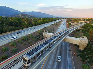
The A Line is a light rail line in Los Angeles County, California. It is one of the six lines of the Los Angeles Metro Rail system, operated by the Los Angeles County Metropolitan Transportation Authority (Metro). The A Line serves 44 stations and runs east-west between Azusa and Pasadena, then north-south between Pasadena and Long Beach, interlining and sharing five stations with the E Line in Downtown Los Angeles. It operates for approximately 19 hours per day with headways of up to 8 minutes during peak hours. It runs for 48.5 miles (78.1 km), making it the world's longest light rail line since 2023.

The E Line is a 22-mile (35 km) light rail line in Los Angeles County, California. It is one of the six lines of the Los Angeles Metro Rail system, operated by the Los Angeles County Metropolitan Transportation Authority (Metro). The E Line runs east-west and serves 29 stations between East Los Angeles and Santa Monica. It interlines and shares five stations with the A Line in Downtown Los Angeles. Service operates for 21 hours per day with headways of up to 8 minutes during peak hours. The E Line, the second-busiest light rail line in the system, saw an average of 41,902 passengers on weekdays in October 2023.

The C Line is a 19.3-mile (31.1 km) light rail line running between the Los Angeles neighborhood of Westchester and the city of Norwalk within Los Angeles County, California. It is one of six lines forming the Los Angeles Metro Rail system and opened on August 12, 1995. Along the route, the line also serves the cities of Downey, Hawthorne, and Lynwood, as well as several unincorporated communities in the South Los Angeles region including Athens, Del Aire, and Willowbrook. The fully grade-separated route runs mainly in the median strip of Interstate 105 for its latitude portion and in a mixture of viaducts, embankments, and an open trench for its western leg. A free shuttle bus to Los Angeles International Airport (LAX) is available at Aviation/LAX station.

The Blue Line is a rapid transit metro line of the Delhi Metro in Delhi, India. Mostly elevated, it is the longest line of the network and consists of a Main Line(Line 3) with 50 stations from Noida Electronic City to Dwarka Sector 21, with a length of 56.11 kilometres and a Branch Line(Line 4) consisting of 8 stations from Vaishali to Yamuna Bank, with a length of 8.51 kilometres.
The Busan Metro is the urban rail system operated by the Busan Transportation Corporation of Busan, South Korea. The metro network first opened in 1985 with seventeen stations, making Busan the second city in South Korea and third in the Korean Peninsula to have a metro system. The Metro itself consists of 4 numbered lines, covering 116.5 kilometres (72.4 mi) of route and serving 114 stations. Including the BGL and the Donghae Line, the network covers 205.6 kilometres (127.8 mi) of route and serving 158 stations.

Line A is a line of the Prague Metro, serving the Czech capital. Chronologically the second line in the system, it was first opened in 1978 and has expanded mostly during the 1980s. With the opening of the extension to Nemocnice Motol on 6 April 2015, Line A operates on approximately 17.1 kilometres (10.6 mi) of route and serves 17 stations. An extension with a further five stations to the airport is currently planned.

The Tunis Metro is the light rail network serving the Tunis metropolitan area. It began operation in 1985.
Suzhou Rail Transit, also known as Suzhou Metro, is a rapid transit system serving the city of Suzhou, in Jiangsu Province, China. Line 1 began operation on April 28, 2012. Line 2 opened on December 28, 2013. A further three lines, and an extension of Line 2, were completed between 2016 and 2021. Line 11 connecting Kunshan city which is under Suzhou's administration, and beyond to the Shanghai Metro was completed on June 24, 2023.

Ahmedabad Metro is a rapid transit system for the cities of Ahmedabad and Gandhinagar in Gujarat state of India. Currently the System is 58.66 km (36.450 mi) and has 38 stations.
Adana Metro is a rail rapid transit system extending 13.5 kilometers (8.39 mi) along a north–south corridor through Adana, with 13 stations. It can transport 21,600 passengers per hour per direction. The total travel time on the metro, end to end, takes 21 minutes, including all stops.

The Delhi Metro is a rapid transit system which serves Delhi and its adjoining satellite cities of Ghaziabad, Faridabad, Gurugram, Noida, Bahadurgarh and Ballabhgarh in the National Capital Region of India. The system consists of 10 colour-coded lines serving 256 stations, with a total length of 350.42 kilometres (217.74 mi). It is India's largest and busiest metro rail system and the second-oldest, after the Kolkata Metro. The metro has a mix of underground, at-grade, and elevated stations using broad-gauge and standard-gauge tracks. The metro makes over 4,300 trips daily.

Rapid Metro Gurgaon is a light metro system serving the city of Gurgaon, Haryana, India. Rapid Metro connects the commercial areas of Gurgaon, and acts as a feeder link to the Delhi Metro with an interchange with its Yellow Line at Sikanderpur metro station.

The Pink Line is a metro rail line of the Delhi Metro, a rapid transit system in Delhi, India. It consists of 38 metro stations from Majlis Park to Shiv Vihar, both in North Delhi.
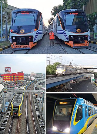
Rail transportation in the Greater Manila Area is a major part of the transportation system in Metro Manila and its surrounding areas. The railway network, collectively known as the Greater Capital Region Railway System, consists of the Manila Light Rail Transit System (LRT), Manila Metro Rail Transit System (MRT), and Philippine National Railways lines within the region.