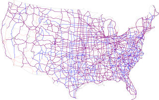
The United States Numbered Highway System is an integrated network of roads and highways numbered within a nationwide grid in the contiguous United States. As the designation and numbering of these highways were coordinated among the states, they are sometimes called Federal Highways, but the roadways were built and have always been maintained by state or local governments since their initial designation in 1926.

The Great River Road is a collection of state and local roads that follow the course of the Mississippi River through ten states of the United States. They are Minnesota, Wisconsin, Iowa, Illinois, Missouri, Kentucky, Tennessee, Arkansas, Mississippi and Louisiana. It formerly extended north into Canada, serving the provinces of Ontario and Manitoba. The road is designated as both a National Scenic Byway and an All-American Road in several states along the route.

Douglas County is a county located in the north central portion of the U.S. state of Georgia. As of the 2020 U.S. Census, the population was 144,237, having more than doubled since 1990. The county seat is Douglasville. The City of Villa Rica, and a small portion of Austell are both also located in Douglas County. Douglas County is included in the Atlanta-Sandy Springs-Roswell, GA Metropolitan Statistical Area. It has attracted new residents as jobs have increased in the Atlanta area.

U.S. Route 281 (US 281) is a north–south United States Numbered Highway. At 1,875 miles (3,018 km) it is the longest continuous three-digit U.S. Route.

U.S. Route 191 is a north–south highway in the Western United States and a spur of parent route U.S. Route 91 that has two segments. The southern segment runs for 1,102 miles (1,773 km) from Douglas, Arizona on the Mexican border to the southern part of Yellowstone National Park. The northern segment runs for 442 miles (711 km) from the northern part of Yellowstone National Park to Loring, Montana, at the Canada–US border. Unnumbered roads within Yellowstone National Park connect the two segments. The highway passes through the states of Arizona, Utah, Wyoming, and Montana.
A routenumber, designation or abbreviation is an identifying numeric designation assigned by a highway authority to a particular stretch of roadway to distinguish it from other routes and, in many cases, also to indicate its classification, general geographical location and/or orientation. The numbers chosen may be used solely for internal administrative purposes; however, in most cases they are also displayed on roadside signage and indicated on maps.

The State Highway System of the U.S. state of Florida comprises the roads maintained by the Florida Department of Transportation (FDOT) or a toll authority. The components are referred to officially as state roads, abbreviated as SR.

The Overseas Highway is a 113-mile (181.9 km) highway carrying U.S. Route 1 (US 1) through the Florida Keys to Key West. Large parts of it were built on the former right-of-way of the Overseas Railroad, the Key West Extension of the Florida East Coast Railway. Completed in 1912, the Overseas Railroad was heavily damaged and partially destroyed in the 1935 Labor Day hurricane. The Florida East Coast Railway was financially unable to rebuild the destroyed sections, so the roadbed and remaining bridges were sold to the state of Florida for $640,000.

In the U.S. state of New Jersey, county routes exist in all 21 counties. They are typically the fourth type of roadway classified below the Interstate Highway, the U.S. Route numbered highway and the state highway. The County Route system is defined by two types in New Jersey. First, 500 Series County Routes, also called state secondary routes, are county highways numbered in a statewide system with three-digit numbers that begin with 5. These roads form a second network of routes that supplement the facilitation of the State Routes. Each 500 Series route is unique and is not permitted to be duplicated in another county for a separate route. The second category is defined as Non-500 Series County Routes. Non-500 Series County Routes include 1-digit, 2-digit, 600 Series, 700 Series and 800 Series. These, by definition, are discontinuous across county borders and must be contained entirely within that county. Unlike 500 Series County routes, these route numbers are unique to each county, and are typically assigned to more local routes than the statewide 500-series county route system. They are typically of a lesser classification of streets like minor arterials or collector roadways rather than major arterials or thoroughfares. In the counties that use 600-series numbers, the selection of this range was coordinated within the state, gradually replacing older systems of mainly one- and two-digit routes.

A county highway is a road in the United States and in the Canadian province of Ontario that is designated and/or maintained by the county highway department. Route numbering can be determined by each county alone, by mutual agreement among counties, or by a statewide pattern.

Route 4 is an 18.6-mile (29.9 km) partial ring road located in Charlotte, North Carolina. Beginning and ending at Interstate 85 (I-85), it loops south around Uptown Charlotte along state-maintained secondary roads, connecting the Charlotte Douglas International Airport and several city neighborhoods including Madison Park, Myers Park, Windsor Park and Sugar Creek. The route is posted by the Charlotte Department of Transportation (CDOT), using a modified pentagonal county road shield, with a green background and the city's crown logo above the number. The loop has a radius of about 4 miles (6.4 km), hence the number.

The North Carolina Highway System consists of a vast network of Interstate, United States, and state highways, managed by the North Carolina Department of Transportation. North Carolina has the second largest state maintained highway network in the United States because all roads in North Carolina are maintained by either municipalities or the state. Since counties do not maintain roads, there is no such thing as a "county road" within the state.
Transportation in Florida includes a variety of options, including Interstate Highways, U.S. Highways, and Florida State Roads; Amtrak and commuter rail services; airports, public transportation, and sea ports, in a number of the state's counties and regions.
In New York, a reference marker is a small green sign mounted approximately every one-tenth mile on highways maintained by the New York State Department of Transportation. This was initiated in response to the Highway Safety Act of 1966 enacted by Congress, in an effort to monitor traffic and identify high-accident locations. New York's system inventories and indexes all touring and reference routes, in addition to service and rest areas, ramps, and reservation roads.
The Philippine highway network is a network of national roads owned and maintained by the Department of Public Works and Highways (DPWH) and organized into three classifications according to their function or purpose: national primary, secondary, and tertiary roads. The national roads connecting major cities are numbered from N1 to N83. They are mostly single and dual carriageways linking two or more cities.


