Midland, Kansas

Last updated
Midland, Kansas
Midland, Kansas.jpg
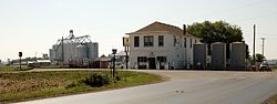
Grain elevator and Midland Farm Store (2014)
Map of Douglas Co, Ks, USA.png
USA Kansas location map.svg
Red pog.svg
Midland
Usa edcp location map.svg
Red pog.svg
Midland
Coordinates: 39°01′42″N95°14′32″W / 39.02833°N 95.24222°W / 39.02833; -95.24222 Coordinates: 39°01′42″N95°14′32″W / 39.02833°N 95.24222°W / 39.02833; -95.24222 [1]
Country United States
State Kansas
County Douglas
Elevation
[1]
840 ft (260 m)
Time zone UTC-6 (CST)
  Summer (DST) UTC-5 (CDT)
Area code 785
FIPS code 20-46275 [1]
GNIS ID 484869 [1]
Grain elevator (2014) Midland, Kansas grain elevator.jpg
Grain elevator (2014)

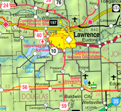
Midland is an unincorporated community in Douglas County, Kansas, United States. [1] It is located two miles north of the city of Lawrence.

Contents

Geography

The climate in this area is characterized by hot, humid summers and generally mild to cool winters. According to the Köppen Climate Classification system, Midland has a humid subtropical climate, abbreviated "Cfa" on climate maps. [2]

Related Research Articles

<span class="mw-page-title-main">Baldwin City, Kansas</span> City in Kansas, United States

Baldwin City is a city in Douglas County, Kansas, United States, about 12 miles (19 km) south of Lawrence. As of the 2020 census, the population of the city was 4,826. The city is home to Baker University, the state's oldest four-year university.

<span class="mw-page-title-main">Ogallah, Kansas</span> Unincorporated community in Trego County, Kansas, United States

Ogallah is an unincorporated community in Trego County, Kansas, United States. As of the 2020 census, the population of the community and nearby areas was 28. It is located approximately 7 miles east of WaKeeney.

<span class="mw-page-title-main">Yoder, Kansas</span> Unincorporated community in Reno County, Kansas

Yoder is an unincorporated community in Reno County, Kansas, United States. As of the 2020 census, the population of the community and nearby areas was 165. It is located approximately 10 miles southeast of the city of Hutchinson on K-96. Although Yoder is unincorporated, with no city government, it does have a U.S. Post Office and its own ZIP code (67585). Yoder is the hub of a local Amish community.

<span class="mw-page-title-main">Peck, Kansas</span> Unincorporated community in Sedgwick and Sumner Counties of Kansas

Peck is an unincorporated community on the Sedgwick and Sumner County border in Kansas, United States. As of the 2020 census, the population of the community and nearby areas was 162. It is located about 2 miles west of the Kansas Star Casino at S Meridian Ave and W 119th St S, next to the railroad.

<span class="mw-page-title-main">Elk, Kansas</span> Ghost town in Marion and Chase Counties of Kansas

Elk is a ghost town in Chase and Marion counties in the U.S. state of Kansas. It is currently a ghost town that lays along Middle Creek northwest of Elmdale and straddled the county line between Chase and Marion County.

<span class="mw-page-title-main">Sycamore, Kansas</span> Unincorporated community in Montgomery County, Kansas

Sycamore is an unincorporated community in northern Montgomery County, Kansas, United States. As of the 2020 census, the population of the community and nearby areas was 70. It is located along U.S. Route 75 north of the city of Independence.

<span class="mw-page-title-main">Beeler, Kansas</span> Unincorporated community in Ness County, Kansas

Beeler is an unincorporated community in Ness County, Kansas, United States. It lies along K-96, west of the city of Ness City, the county seat of Ness County. Its elevation is 2,490 feet (759 m), and it is located at 38°26′40″N100°11′41″W. It has a post office with the ZIP code 67518.

<span class="mw-page-title-main">Bridgeport, Kansas</span> Unincorporated community in Saline County, Kansas

Bridgeport is an unincorporated community in Smoky View Township, Saline County, Kansas, United States. As of the 2020 census, the population of the community and nearby areas was 64. It is located south of Salina, along K-4 near Interstate 135.

<span class="mw-page-title-main">Centerville, Kansas</span> Unincorporated community in Kansas, United States

Centerville is an unincorporated community in Linn County, Kansas, United States. As of the 2020 census, the population of the community and nearby areas was 78. It is located 8.5 miles (13.7 km) north of the city of Blue Mound.

<span class="mw-page-title-main">Fostoria, Kansas</span> Unincorporated community in Pottawatomie County, Kansas

Fostoria is an unincorporated community in Pottawatomie County, Kansas, United States. Fostoria is 6 miles (9.7 km) east of Olsburg. Fostoria has a post office with ZIP code 66426.

<span class="mw-page-title-main">Vassar, Kansas</span> Unincorporated community in Kansas, United States

Vassar is an unincorporated community in Osage County, Kansas, United States. As of the 2020 census, the population of the community and nearby areas was 584. It is located 4 miles (6.4 km) northeast of Lyndon, also about half a mile south of Pomona Lake.

<span class="mw-page-title-main">Greenwich, Kansas</span> Unincorporated community in Sedgwick County, Kansas

Greenwich is an unincorporated community in Sedgwick County, Kansas, United States. As of the 2020 census, the population of the community and nearby areas was 64. It is located northeast of 53rd St North and Greenwich Rd.

<span class="mw-page-title-main">Rosalia, Kansas</span> Unincorporated community in Butler County, Kansas

Rosalia is an unincorporated community in Butler County, Kansas, United States. As of the 2020 census, the population of the community and nearby areas was 149. It is located approximately 12 miles (19 km) east of El Dorado.

<span class="mw-page-title-main">Wright, Kansas</span> Unincorporated community in Ford County, Kansas

Wright is an unincorporated community in Ford County, Kansas, United States. As of the 2020 census, the population of the community and nearby areas was 145.

<span class="mw-page-title-main">Deerhead, Kansas</span> Unincorporated community in Barber County, Kansas

Deerhead is an unincorporated community in Barber County, Kansas, United States. It is 18 miles (29 km) west-southwest of Medicine Lodge.

<span class="mw-page-title-main">Miller, Kansas</span> Unincorporated community in Lyon County, Kansas

Miller is an unincorporated community in Lyon County, Kansas, United States. It is located approximately 5.5 miles east of the city of Admire along Rd W7.

<span class="mw-page-title-main">Kalvesta, Kansas</span> Unincorporated community in Finney County, Kansas

Kalvesta is an unincorporated community in Finney County, Kansas, United States. It is located along K-156 about 20 miles (32 km) west of Jetmore and 18 miles (29 km) north-northeast of Cimarron. Kalvesta consists only of two large grain elevators and a dealership for heavy farm implements, along with half a dozen houses.

<span class="mw-page-title-main">Covert, Kansas</span> Unincorporated community in Osborne County, Kansas

Covert is an unincorporated community in Covert Township, Osborne County, Kansas, United States. It is located southwest of Osborne.

Barclay is an unincorporated community in Osage County, Kansas, United States.

<span class="mw-page-title-main">De Graff, Kansas</span> Unincorporated community in Butler County, Kansas

De Graff is an unincorporated community in Butler County, Kansas, United States. It is located on U.S. Route 77 approximately 7.7 miles (12.4 km) north of I-35

References

  1. 1 2 3 4 5 "Midland, Kansas", Geographic Names Information System , United States Geological Survey, United States Department of the Interior
  2. "Midland, Kansas". Weather Base. Retrieved January 24, 2018.

Further reading