Weaver, Kansas

Last updated

Weaver, Kansas
Weaver KS.jpg
N 1600 Rd in Weaver Bottoms
Map of Douglas Co, Ks, USA.png
USA Kansas location map.svg
Red pog.svg
Weaver
Usa edcp location map.svg
Red pog.svg
Weaver
Coordinates: 38°57′43″N95°04′01″W / 38.96194°N 95.06694°W / 38.96194; -95.06694
Country United States
State Kansas
County Douglas
Founded1865
Named for Henry Weaver
Elevation
1,089 ft (332 m)
Population
  Estimate 
()
0
Time zone UTC-6 (CST)
  Summer (DST) UTC-5 (CDT)
Area code 785
GNIS ID 484879 [1]

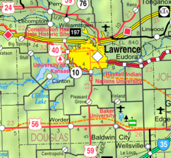
Weaver is a ghost town in Douglas County, Kansas, United States. [2] It is located one mile northeast of Eudora.

Contents

History

The area was once owned by a group of Shawnee Native Americans. By 1865 several investors took ownership of the area before Henry Weaver obtained a large portion of the land. Henry and his wife, Nancy (Hill) came to the area from Pennsylvania along with their seven children. John F. Weaver, Henry's youngest son went on to own several businesses in the Weaver area including a general store, rock crushing business and a potato bucket manufacturing company. [3]

A post office called Weaver was established in 1891, and remained in operation until 1903. The Weaver community was located close to the southern bank of the Kansas River. The area lies in a region called "Weaver Bottoms," which is in the Kansas River floodplain. Therefore, the community was the victim of frequent flooding. Floods in 1903 and 1908 significantly damaged the community. The Great Flood of 1951 destroyed every remnant of the community, and forced all residents to leave the community permanently. No trace of Weaver exists as of 2021.

Related Research Articles

<span class="mw-page-title-main">Douglas County, Kansas</span> County in Kansas, United States

Douglas County is located in the U.S. state of Kansas. Its county seat and most populous city is Lawrence. As of the 2020 census, the county population was 118,785, making it the fifth-most populous county in Kansas. The county was named after Stephen Douglas, a U.S. Senator from Illinois and advocate for the popular sovereignty choice in the Kansas slavery debate.

<span class="mw-page-title-main">Eudora, Kansas</span> City in Kansas, United States

Eudora is a city in Douglas County, Kansas, United States, along the Kansas and Wakarusa rivers. As of the 2020 census, the population of the city was 6,408.

<span class="mw-page-title-main">Smoky Hill River</span> River in the United States

The Smoky Hill River is a 575-mile (925 km) river in the central Great Plains of North America, running through Colorado and Kansas.

<span class="mw-page-title-main">Cumberland River</span> River in Kentucky and Tennessee, United States

The Cumberland River is a major waterway of the Southern United States. The 688-mile-long (1,107 km) river drains almost 18,000 square miles (47,000 km2) of southern Kentucky and north-central Tennessee. The river flows generally west from a source in the Appalachian Mountains to its confluence with the Ohio River near Paducah, Kentucky, and the mouth of the Tennessee River. Major tributaries include the Obey, Caney Fork, Stones, and Red Rivers.

Turner is a neighborhood within Kansas City, Kansas, United States. It was formerly an unincorporated community of Wyandotte County, similar to Piper, Kansas. Turner has its own school district, Turner USD #202.

<span class="mw-page-title-main">Wakarusa River</span> River in Kansas, United States

The Wakarusa River is a tributary of the Kansas River, approximately 80.5 miles (129.6 km) long, in eastern Kansas in the United States. It drains an agricultural area of rolling limestone hills south of Topeka and Lawrence.

<span class="mw-page-title-main">Arikaree River</span> River in the central United States

The Arikaree River is a 156-mile-long (251 km) river in the central Great Plains of North America. It lies mostly in the American state of Colorado, draining land between the North and South Forks of the Republican River, and it flows into the North Fork in Nebraska after flowing a short distance through Kansas. It is a designated area within the Colorado Natural Areas Program to protect native and uncommon species that may be endangered or threatened.

<span class="mw-page-title-main">Clinton Lake (Kansas)</span> Large artificial lake located in Douglas County Kansas

Clinton Lake is a reservoir on the southwestern edge of Lawrence, Kansas. The lake was created by the construction of the Clinton Dam, and the 35 square miles (91 km2) of land and water is maintained by the U.S. Army Corps of Engineers.

<span class="mw-page-title-main">Richland, Kansas</span> Ghost town in Kansas, United States

Richland is currently a ghost town in southeastern Shawnee County, Kansas, United States.

<span class="mw-page-title-main">Eudora Township, Douglas County, Kansas</span> Township in Kansas, United States

Eudora Township is a township in Douglas County, Kansas, USA. As of the 2010 census, its population was 6,724.

<span class="mw-page-title-main">Grant Township, Douglas County, Kansas</span> Township in Kansas, United States

Grant Township is a township in Douglas County, Kansas, USA. As of the 2000 census, its population was 442.

<span class="mw-page-title-main">Palmyra Township, Douglas County, Kansas</span> Township in Kansas, United States

Palmyra Township is a township in Douglas County, Kansas, USA. As of 2000 census, its population was 5,760. It was named after a small trail stop on the Santa Fe Trail that was later absorbed into Baldwin City. When it was first established in 1855, it was called Calhoun, until 1858.

<span class="mw-page-title-main">Wakarusa Township, Douglas County, Kansas</span> Township in Kansas, United States

Wakarusa Township is a township in Douglas County, Kansas, USA. As of the 2010 census, its population was 2,318. It was named for the Wakarusa River which flows through Douglas County from Wabaunsee County to the Kansas River near Eudora.

<span class="mw-page-title-main">Williamstown, Kansas</span> Unincorporated community in Kansas, United States

Williamstown is an unincorporated community in southeastern Jefferson County, Kansas, United States. As of the 2020 census, the population of the community and nearby areas was 96. It is located south of the junction of US-24 and US-59 highways.

<span class="mw-page-title-main">Saxman, Kansas</span> Unincorporated community in Rice County, Kansas

Saxman is an unincorporated community in Rice County, Kansas, United States. Located along Cow Creek just above its confluence with Jarvis Creek, it lies along local roads southeast of Lyons.

<span class="mw-page-title-main">Hesper, Kansas</span> Unincorporated community in Douglas County, Kansas

Hesper is an unincorporated community in Douglas County, Kansas, United States. It is located two and a half miles southeast of Eudora.

<span class="mw-page-title-main">Saffordville, Kansas</span> Unincorporated community in Chase County, Kansas

Saffordville is an unincorporated community in Chase County, Kansas, United States. It is located about half way between Strong City and Emporia near the intersection of U.S. Route 50 highway and Zz Rd. BNSF Railway passes through it.

Linwood is an unincorporated community in Cherokee County, located in the U.S. state of Texas. According to the Handbook of Texas, the community had a population of 40 in 2000. It is located within the Tyler-Jacksonville combined statistical area.

Huntington is a ghost town in Bolivar County, Mississippi, United States.

<span class="mw-page-title-main">Haskell Limestone</span>

Haskell Limestone is a geological unit name originating in Kansas and used in adjoining states. The Pennsylvanian period unit was named by R.C. Moore for the Haskell Institute in the southeast of Lawrence, Kansas in 1931. The name has been applied to various beds within this range, and assigned as a member variously to the Lawrence Formation, Cass Formation, and Stranger Formation, and significant legacy literature exists for each classification. These three formations now comprise the Douglas Group.

References

  1. "US Board on Geographic Names". United States Geological Survey. October 25, 2007. Retrieved January 31, 2008.
  2. U.S. Geological Survey Geographic Names Information System: Weaver, Kansas
  3. "WEAVER". The History of Eudora, Kansas. Retrieved November 18, 2023.

Further reading