Palmyra Township, Douglas County, Kansas

Last updated

Palmyra Township
Signal Oak view.JPG
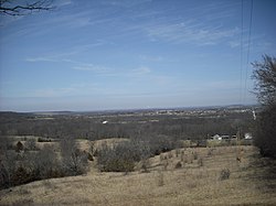
Signal Oak, a historic spot
Map highlighting Palmyra Township, Douglas County, Kansas.svg
Location in Douglas County
Coordinates: 38°47′20″N095°09′01″W / 38.78889°N 95.15028°W / 38.78889; -95.15028
Country United States
State Kansas
County Douglas
Area
  Total
82.57 sq mi (213.86 km2)
  Land81.92 sq mi (212.17 km2)
  Water0.65 sq mi (1.69 km2)  0.79%
Elevation
1,050 ft (320 m)
Population
 (2000)
  Total
5,760
  Density70.3/sq mi (27.1/km2)
GNIS feature ID 0479537
A marker near the townsite of Brooklyn Brooklyn Townsite.jpg
A marker near the townsite of Brooklyn
The boulder marking the location of Signal Oak Signal Oak bouldar.JPG
The boulder marking the location of Signal Oak

Palmyra Township is a township in Douglas County, Kansas, United States. As of 2000 census, its population was 5,760.

Contents

History

It was named after a small trail stop on the Santa Fe Trail that was later absorbed into Baldwin City. [1] When it was first established in 1855, it was called Calhoun, until 1858.

Geography

Palmyra Township covers an area of 82.57 square miles (213.9 km2) and contains one incorporated settlement, Baldwin City. According to the USGS, it contains six cemeteries: Baldwin City, Brumbaugh, Oakwood, Old Black Jack, Prairie City and Vinland.

The stream of Wymore Creek runs through this township.

Adjacent townships

Communities

Although these towns may not be incorporated or populated, they are still placed on maps produced by the county.

Transportation

Major highways

Airports

Palmyra Township contains one airport or landing strip, Vinland Valley Aerodrome.

Places of interest

References

  1. Cleland, Nora (June 12, 1961). "Only few of 45 county settlements left". Lawrence Journal-World. p. 13A. Retrieved November 1, 2015.