Clearfield, Kansas

Last updated

Clearfield, Kansas
Clearfield Church.jpg
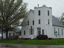
Clearfield United Methodist Church (2011)
Map of Douglas Co, Ks, USA.png
USA Kansas location map.svg
Red pog.svg
Clearfield
Usa edcp location map.svg
Red pog.svg
Clearfield
Coordinates: 38°49′34″N95°05′37″W / 38.82611°N 95.09361°W / 38.82611; -95.09361 [1]
Country United States
State Kansas
County Douglas
Elevation
[1]
1,001 ft (305 m)
Time zone UTC-6 (CST)
  Summer (DST) UTC-5 (CDT)
Area code 785
FIPS code 20-13850 [1]
GNIS ID 484894 [1]

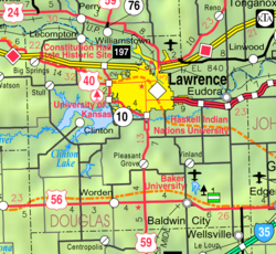
Clearfield is an unincorporated community in Douglas County, Kansas, United States, [1] and is located northeast of Baldwin City at the intersection of E 2200 Rd and N 600 Rd.

Contents

History

A post office was opened in Clearfield in 1885, and remained in operation until it was discontinued in 1900. [2]

Related Research Articles

<span class="mw-page-title-main">Douglas County, Kansas</span> County in Kansas, United States

Douglas County is located in the U.S. state of Kansas. Its county seat and most populous city is Lawrence. As of the 2020 census, the county population was 118,785, making it the fifth-most populous county in Kansas. The county was named after Stephen Douglas, a U.S. Senator from Illinois and advocate for the moderate popular sovereignty choice in the Kansas slavery debate.

<span class="mw-page-title-main">Douglas County, Georgia</span> County in Georgia, United States

Douglas County is a county located in the north central portion of the U.S. state of Georgia. As of the 2020 U.S. Census, the population was 144,237, having more than doubled since 1990. The county seat is Douglasville. The City of Villa Rica, and a small portion of Austell are both also located in Douglas County. Douglas County is included in the Atlanta-Sandy Springs-Roswell, GA Metropolitan Statistical Area. It has attracted new residents as jobs have increased in the Atlanta area.

<span class="mw-page-title-main">William Bigler</span> American politician

William Bigler was an American politician from Pennsylvania who served as a Democrat as the 12th governor of Pennsylvania from 1852 to 1855 and as a member of the United States Senate for Pennsylvania from 1856 to 1861. His older brother, John Bigler, was elected governor of California during the same period. As of 2023, he is the last Democratic incumbent to lose reelection as Governor of Pennsylvania.

Eden is an unincorporated community in Atchison County, Kansas, United States. It is about 5 miles west and 5 miles north of Atchison. It lies at the present-day intersection of Labette Rd, 322nd Rd, and 326th Rd.

<span class="mw-page-title-main">Illinois's 5th congressional district</span> U.S. House district for Illinois

The 5th congressional district of Illinois covers parts of Cook and Lake counties, as of the 2023 redistricting which followed the 2010 census. All or parts of Chicago, Inverness, Arlington Heights, Barrington Hills, Des Plaines, Palatine, Mount Prospect, Deer Park, Kildeer, Lake Zurich, Long Grove, and North Barrington are included.

<span class="mw-page-title-main">Lyona, Kansas</span> Unincorporated community in Dickinson County, Kansas

Lyona is an unincorporated community in Liberty Township, Dickinson County, Kansas, United States. It is located on Wolf Rd approximately 8.7 miles (14.0 km) southwest of Junction City or 12.3 miles (19.8 km) north of Herington, also it is 1.5 miles (2.4 km) west of the Rock Springs 4-H Camp.

<span class="mw-page-title-main">Shady Brook, Kansas</span> Unincorporated community in Dickinson County, Kansas

Shady Brook is an unincorporated community in Dickinson County, Kansas, United States. It is located at the intersection of 1000 Ave and Trail Rd.

<span class="mw-page-title-main">Sutphen, Kansas</span> Unincorporated community in Dickinson County, Kansas

Sutphen is an unincorporated community in Dickinson County, Kansas, United States. It is located north of the intersection of 3100 Ave and Paint Rd.

<span class="mw-page-title-main">North Branch, Kansas</span> Unincorporated community in Jewell County, Kansas

North Branch is an unincorporated community in Jewell County, Kansas, United States. It is located 2 miles south of the Nebraska/Kansas state line at the intersection of Cedar Rd and 78 Rd.

<span class="mw-page-title-main">Palmyra Township, Douglas County, Kansas</span> Township in Kansas, United States

Palmyra Township is a township in Douglas County, Kansas, USA. As of 2000 census, its population was 5,760. It was named after a small trail stop on the Santa Fe Trail that was later absorbed into Baldwin City. When it was first established in 1855, it was called Calhoun, until 1858.

<span class="mw-page-title-main">Zeandale, Kansas</span> Unincorporated community in Riley County, Kansas

Zeandale is an unincorporated community in Riley County, Kansas, United States. As of the 2020 census, the population of the community and nearby areas was 62. It is located about 6.8 miles (10.9 km) east of Manhattan at the intersection of Tabor Valley Rd and K-18 highway.

Capioma is an unincorporated community in Capioma Township, Nemaha County, Kansas, United States. It is located at the intersection of 116th Rd and W4 Rd.

Woodlawn is an unincorporated community in Nemaha County, Kansas, United States. It is located at the intersection of 120th Rd and U Rd.

Halls Summit is an unincorporated community in Coffey County, Kansas, United States. It is located at the intersection of 22nd Rd NW and Planter Rd.

Sharpe is an unincorporated community in Coffey County, Kansas, United States. It is located at the intersection of 18th Rd NE and Oxen Rd NE.

<span class="mw-page-title-main">Norwood, Kansas</span> Ghost town in Franklin County, Kansas

Norwood is a ghost town in north Franklin County, Kansas, United States. It is located approximately 1.25 miles (2.01 km) east of U.S. Route 59 on Stafford Rd, and 2 miles (3.2 km) south of the Franklin-Douglas county line.

<span class="mw-page-title-main">Groveland, Kansas</span> Unincorporated community in McPherson County, Kansas

Groveland is an unincorporated community in McPherson County, Kansas, United States. It is located southwest of McPherson at K-61 highway and Comanche Rd.

Talmo is an unincorporated community in Republic County, Kansas, United States. It is located northeast of Concordia along K-148 highway between Co Rd 19 and Co Rd 20.

<span class="mw-page-title-main">Toledo, Kansas</span> Unincorporated community in Chase County, Kansas

Toledo is an unincorporated community in Chase County, Kansas, United States. It is located about 7 miles west of Emporia at the intersection of Yy Rd and 240 Rd.

Aliceville is an unincorporated community in Coffey County, Kansas, United States. It is located at the intersection of 9th Rd SE and Wayside Rd SE.

References

  1. 1 2 3 4 5 "Clearfield, Kansas", Geographic Names Information System , United States Geological Survey, United States Department of the Interior
  2. "Kansas Post Offices, 1828-1961 (archived)". Kansas Historical Society. Archived from the original on March 10, 2013. Retrieved June 8, 2014.

Further reading