Big Springs, Kansas

Last updated

Big Springs, Kansas
Big Springs.JPG
Big Springs along Highway 40 (2008)
Map of Douglas Co, Ks, USA.png
USA Kansas location map.svg
Red pog.svg
Big Springs
Usa edcp location map.svg
Red pog.svg
Big Springs
Coordinates: 39°0′47″N95°29′6″W / 39.01306°N 95.48500°W / 39.01306; -95.48500 [1]
Country United States
State Kansas
County Douglas
Named for Nearby springs
Elevation
[1]
1,102 ft (336 m)
Time zone UTC-6 (CST)
  Summer (DST) UTC-5 (CDT)
Area code 785
FIPS code 20-06750 [1]
GNIS ID 484942 [1]

Big Springs is an unincorporated community in northwest Douglas County, Kansas, United States. [1]

Contents

History

The first settlement at Big Springs was made in the fall of 1854. [2] The town was founded by William Harper and John Chamberlain but had always been a popular watering hole along the Oregon Trail. It was named from the mineral springs nearby. [3] [4] On September 5, 1855, Big Springs was home to a free-state convention in which determined men vowed to give their lives to defend their homes from border ruffians from Missouri. The first sermon was preached in 1855 by Reverend W.A. Cardwell in the log home of Ephraim Banning. The first church was built a year later. [5] Also in 1856, the first post office was established, as well as the first schooling took place then in the town hall. The post office was discontinued in 1903. [6] The population did not grow, but hovered around 40 people, as there was no railroad running through the town.

According to the Lawrence Journal-World , Big Springs was the location of T. J. Custard's birth, making him the first American citizen to be born in Douglas County. [7]

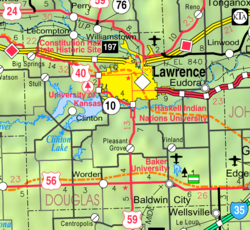
Today it has a water tower, tool shop, church and a fire station that is part of the Lecompton Township Fire Dist. 1. Its mailing address is Lecompton.

In 2010, a building on the east side of town caught fire, leaving a restricted area of charred rubble.

Education

It is part of USD 450 Shawnee Heights School District in Tecumseh.

Infrastructure

US Highway 40 runs through the community.

Related Research Articles

<span class="mw-page-title-main">Douglas County, Kansas</span> County in Kansas, United States

Douglas County is located in the U.S. state of Kansas. Its county seat and most populous city is Lawrence. As of the 2020 census, the county population was 118,785, making it the fifth-most populous county in Kansas. The county was named after Stephen Douglas, a U.S. Senator from Illinois and advocate for the moderate popular sovereignty choice in the Kansas slavery debate.

<span class="mw-page-title-main">Lawrence, Kansas</span> City and County seat in Kansas, United States

Lawrence is the county seat of Douglas County, Kansas, United States, and the sixth-largest city in the state. It is in the northeastern sector of the state, astride Interstate 70, between the Kansas and Wakarusa Rivers. As of the 2020 census, the population of the city was 94,934. Lawrence is a college town and the home to both the University of Kansas and Haskell Indian Nations University.

<span class="mw-page-title-main">Lecompton, Kansas</span> City in Kansas, United States

Lecompton is a city in Douglas County, Kansas, United States. As of the 2020 census, the population of the city was 588. Lecompton was the de jure territorial capital of Kansas from 1855 to 1861, and the Douglas County seat from 1855 to 1858. Anti-slavery Lawrence became the de facto capital during the latter part of this period, when the county seat was moved there. This time period was known as Bleeding Kansas, due to the violence perpetrated by the pro-slavery, and to a lesser extent the anti-slavery, factions in the eastern part of the state. Lecompton was a hotbed of pro-slavery sentiment during the mid-1800s.

<span class="mw-page-title-main">Perry, Kansas</span> City in Kansas, United States

Perry is a city in Jefferson County, Kansas, United States. As of the 2020 census, the population of the city was 852.

The U.S. state of Kansas, located on the eastern edge of the Great Plains, was the home of nomadic Native American tribes who hunted the vast herds of bison. In around 1450 AD, the Wichita People founded the great city of Etzanoa. The city of Etzanoa was abandoned in around 1700 AD. The region was explored by Spanish conquistadores in the 16th century. It was later explored by French fur trappers who traded with the Native Americans. Most of Kansas became permanently part of the United States in the Louisiana Purchase of 1803. When the area was opened to settlement by the Kansas–Nebraska Act of 1854 it became a battlefield that helped cause the American Civil War. Settlers from North and South came in order to vote slavery down or up. The free state element prevailed.

<span class="mw-page-title-main">Vinland, Kansas</span> Unincorporated community in Kansas, United States

Vinland is an unincorporated community in Douglas County, Kansas, United States. It is located south of Lawrence and north of Baldwin City.

<span class="mw-page-title-main">Sacking of Lawrence</span> 1856 destruction of the Kansas Territory town

The sacking of Lawrence occurred on May 21, 1856, when pro-slavery settlers, led by Douglas County Sheriff Samuel J. Jones, attacked and ransacked Lawrence, Kansas, a town which had been founded by anti-slavery settlers from Massachusetts who were hoping to make Kansas a free state. The incident fueled the irregular conflict in Kansas Territory that later became known as Bleeding Kansas.

The Wakarusa War was an armed standoff that took place in the Kansas Territory during November and December 1855. It is often cited by historians as the first instance of violence during the "Bleeding Kansas" conflict between anti-slavery and pro-slavery factions in the region.

<span class="mw-page-title-main">Stull, Kansas</span> Unincorporated community in Kansas, United States

Stull is an unincorporated community in Douglas County, Kansas, United States. Founded in 1857, the settlement was initially known as Deer Creek until it was renamed after its only postmaster, Sylvester Stull. As of 2018, only a handful of structures remain in the area.

<span class="mw-page-title-main">Clinton, Kansas</span> Unincorporated community in Kansas, United States

Clinton is an unincorporated community on a peninsula next to Clinton Lake in Douglas County, Kansas, United States.

The timeline of Kansas details past events that happened in what is present day Kansas. Located on the eastern edge of the Great Plains, the U.S. state of Kansas was the home of sedentary agrarian and hunter-gatherer Native American societies, many of whom hunted American bison. The region first appears in western history in the 16th century at the time of the Spanish conquest of the Aztec Empire, when Spanish conquistadors explored the unknown land now known as Kansas. It was later explored by French fur trappers who traded with the Native Americans. It became part of the United States in the Louisiana Purchase of 1803. In the 19th century, the first American explorers designated the area as the "Great American Desert."

<span class="mw-page-title-main">Lecompton Township, Douglas County, Kansas</span> Township in Kansas, United States

Lecompton Township is a township in Douglas County, Kansas, USA. As of the 2000 census, its population was 1,761.

<span class="mw-page-title-main">Palmyra Township, Douglas County, Kansas</span> Township in Kansas, United States

Palmyra Township is a township in Douglas County, Kansas, USA. As of the 2000 census, its population was 5,760. It was named after a small trail stop on the Santa Fe Trail that was later absorbed into Baldwin City. When it was first established in 1855, it was called Calhoun, until 1858.

<span class="mw-page-title-main">Wakarusa Township, Douglas County, Kansas</span> Township in Kansas, United States

Wakarusa Township is a township in Douglas County, Kansas, USA. As of the 2010 census, its population was 2,318. It was named for the Wakarusa River which flows through Douglas County from Wabaunsee County to the Kansas River near Eudora.

<span class="mw-page-title-main">Constitution Hall (Lecompton, Kansas)</span> United States historic place

Lecompton Constitution Hall, also known as Constitution Hall, is a building in Lecompton, Kansas, that played an important role in the long-running Bleeding Kansas crisis over slavery in Kansas. It is operated by the Kansas Historical Society as Constitution Hall State Historic Site.

<span class="mw-page-title-main">Globe, Kansas</span> Unincorporated community in Kansas, United States

Globe is an unincorporated community in Douglas County, Kansas, United States. It is located along U.S. Highway 56 in Marion Township. To the west of Globe is the Simmons Point Station.

<span class="mw-page-title-main">Lone Star, Kansas</span> Unincorporated community in Kansas, United States

Lone Star is an unincorporated community in Douglas County, Kansas, United States. It is located 7 miles (11 km) southwest of Lawrence.

Franklin is a ghost town in Douglas County, Kansas, United States. Established as a proslavery stronghold, the town played a key role in the "Bleeding Kansas" conflict that troubled the territory in the 1850s.

<span class="mw-page-title-main">Samuel J. Jones</span> American frontier settler

Samuel Jefferson Jones was a pro-slavery settler who held the position of Douglas County sheriff in Kansas Territory from late 1855 until early 1857. He helped found the territorial capital of Lecompton and played a prominent role in the "Bleeding Kansas" conflict.

References

  1. 1 2 3 4 5 "Big Springs, Kansas", Geographic Names Information System , United States Geological Survey, United States Department of the Interior
  2. History of the State of Kansas: Containing a Full Account of Its Growth from an Uninhabited Territory to a Wealthy and Important State. A. T. Andreas. 1883. p.  352.
  3. Heim, Michael (2007). Exploring Kansas Highways. p. 49. ISBN   9780974435886.
  4. Carpenter, Tim (November 28, 1997). "What's in a name? Key elements of area history". Lawrence Journal-World. pp. 3B. Retrieved April 28, 2015.
  5. Cleland, Nora (June 12, 1961). "Only few of 45 county settlements left". Lawrence Journal-World. pp. 12A. Retrieved November 1, 2015.
  6. "Kansas Post Offices, 1828-1961, page 2". Kansas Historical Society. Retrieved June 8, 2014.
  7. Carpenter, Tim (November 28, 1997). "What's in a Name? Key Elements of Area History". Lawrence Journal-World . p. 3B. Retrieved April 28, 2015.

Further reading