Tecumseh, Kansas

Last updated

Tecumseh, Kansas
Tecumseh, KS.JPG
The main part of Tecumseh has a church, Topeka & Shawnee County Public Library bookmobile stop and book drop-off box, and United States Postal Service office.
Map of Shawnee Co, Ks, USA.png
USA Kansas location map.svg
Red pog.svg
Tecumseh
Usa edcp location map.svg
Red pog.svg
Tecumseh
Coordinates: 39°2′53″N95°34′45″W / 39.04806°N 95.57917°W / 39.04806; -95.57917 [1]
Country United States
State Kansas
County Shawnee
Elevation
[1]
912 ft (278 m)
Population
 (2020) [2]
  Total696
Time zone UTC-6 (CST)
  Summer (DST) UTC-5 (CDT)
ZIP code
66542
Area code 785
FIPS code 20-70075
GNIS ID 2804537 [1]

Tecumseh is an unincorporated community in Shawnee County, Kansas, United States, [1] and situated along the Kansas River. As of the 2020 census, the population of the community and nearby areas was 696. [2] The community and township are both named for the Shawnee chief. [3] [4]

Contents

History

By September 1, 1854, Thomas Stinson platted the townsite of Tecumseh, having settled in the area within the Kansas Territory. [3] It was settled by pro-slavery partisans in the turbulent days of Bleeding Kansas. It temporarily served as the pro-southern capital of the territory and prospered, even having a newspaper. The town's post office opened in March 1855. [5] In 1886, the brick courthouse was sold for US$500(equivalent to $17,000 in 2023) and removed. [3] After the Civil War, the town rapidly declined and remained so for the next ninety years.

Construction of the Kansas Power & Light Co. power plant in 1924 and 1925. In 1958, DuPont established a cellophane plant east of town which created a minor boom. [3] As Topeka grew in the 1950s, Tecumseh again started to grow, this time as a suburb of Topeka, with numerous suburban housing subdivisions. In 2018, the Tecumseh Energy Center owned by Westar (later Evergy) closed the plant and the facility was demolished. [6]

Geography

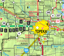
Tecumseh is located in Section 36, Township 11 south, Range 16 east. It is situated south of the Kansas River between Tecumseh Creek to the east and Stinson Creek to the west. Contained entirely within Tecumseh Township, it is about 2 miles east of the Topeka city limits. [7] U.S. Route 40 passes the south side of Tecumseh. A BNSF rail line—running between Lawrence and Topeka—passes north of the town between it and the river.

Demographics

Historical population
CensusPop.Note
2020 696
U.S. Decennial Census

Tecumseh is part of the Topeka, Kansas Metropolitan Statistical Area.

For statistical purposes, the United States Census Bureau has defined this community as a census-designated place (CDP).

Economy

The community includes a public school (part of USD 450), two churches, a post office, and a cellophane factory. [8]

Education

The community is served by Shawnee Heights USD 450 public school district.

Related Research Articles

<span class="mw-page-title-main">Topeka, Kansas</span> State capital city of Kansas, United States

Topeka is the capital city of the U.S. state of Kansas and the seat of Shawnee County. It is along the Kansas River in the central part of Shawnee County, in northeast Kansas, in the Central United States. As of the 2020 census, the population of the city was 126,587. The Topeka metropolitan statistical area, which includes Shawnee, Jackson, Jefferson, Osage, and Wabaunsee Counties, had a population of 233,870 in the 2010 census.

<span class="mw-page-title-main">Wabaunsee County, Kansas</span> County in Kansas, United States

Wabaunsee County is a county located in the U.S. state of Kansas. Its county seat is Alma. As of the 2020 census, the county population was 6,877. The county was named for Chief Waubonsie of the Potawatomi Indians.

<span class="mw-page-title-main">Shawnee County, Kansas</span> County in Kansas, United States

Shawnee County is located in northeast Kansas, in the central United States. Its county seat and most populous city is Topeka, the state capital. As of the 2020 census, the population was 178,909, making it the third-most populous county in Kansas. The county was one of the original 33 counties created by the first territorial legislature in 1855, and it was named for the Shawnee tribe.

<span class="mw-page-title-main">Pottawatomie County, Kansas</span> County in Kansas, United States

Pottawatomie County is a county located in the U.S. state of Kansas. Its county seat is Westmoreland. As of the 2020 census, the county population was 25,348. The county was named for the Potawatomi tribe.

<span class="mw-page-title-main">Osage County, Kansas</span> County in Kansas, United States

Osage County is a county located in the U.S. state of Kansas. Its county seat is Lyndon, and its most populous city is Osage City. As of the 2020 census, the county population was 15,766. The county was originally organized in 1855 as Weller County, then renamed in 1859 after the Osage tribe.

<span class="mw-page-title-main">Nemaha County, Kansas</span> County in Kansas, United States

Nemaha County is a county located in the northeastern part of the U.S. state of Kansas. Its county seat is Seneca. As of the 2020 census, the county population was 10,273. The county was named for the Nemaha River.

<span class="mw-page-title-main">Jefferson County, Kansas</span> County in Kansas, United States

Jefferson County is a county located in the U.S. state of Kansas. Its county seat and most populous city is Oskaloosa. As of the 2020 census, the county population was 18,368. The county was named after Thomas Jefferson, the 3rd president of the United States.

<span class="mw-page-title-main">Ellis County, Kansas</span> County in Kansas, United States

Ellis County is a county located in the U.S. state of Kansas. Its county seat and most populous city is Hays. As of the 2020 census, the county population was 28,934. The county was named for George Ellis, a first lieutenant of the Twelfth Kansas Infantry. Ellis County is the official German Capital of Kansas. German immigrants settled in Hays, Ellis, Victoria, and nearby villages in the 1870s and 1880s.

<span class="mw-page-title-main">Cheyenne County, Kansas</span> County in Kansas, United States

Cheyenne County is a county located in the northwest corner of the U.S. state of Kansas. Its county seat and most populous city is St. Francis. As of the 2020 census, the county population was 2,616. The county was named after the Cheyenne tribe.

<span class="mw-page-title-main">Dover, Kansas</span> Unincorporated community in Shawnee County, Kansas

Dover is an unincorporated community in Shawnee County, Kansas, United States. It is located southwest of Topeka.

<span class="mw-page-title-main">Silverdale, Kansas</span> Unincorporated community in Cowley County, Kansas

Silverdale is an unincorporated community in Silverdale Township, Cowley County, Kansas, United States. As of the 2020 census, the population of the community and nearby areas was 61.

<span class="mw-page-title-main">Talmage, Kansas</span> Unincorporated community in Dickinson County, Kansas

Talmage is an unincorporated community in Dickinson County, Kansas, United States. As of the 2020 census, the population of the city was 78.

<span class="mw-page-title-main">Berryton, Kansas</span> Unincorporated community in Shawnee County, Kansas

Berryton is an unincorporated community in Shawnee County, Kansas, United States. It is located east of the Topeka Regional Airport.

<span class="mw-page-title-main">Big Springs, Kansas</span> Unincorporated community in Kansas, United States

Big Springs is an unincorporated community in northwest Douglas County, Kansas, United States.

<span class="mw-page-title-main">Petrolia, Kansas</span> Unincorporated community in Allen County, Kansas

Petrolia is an unincorporated community in Allen County, Kansas, United States. It is situated along the Neosho River.

<span class="mw-page-title-main">Lecompton Township, Douglas County, Kansas</span> Township in Kansas, United States

Lecompton Township is a township in Douglas County, Kansas, USA. As of the 2000 census, its population was 1,761.

<span class="mw-page-title-main">Grantville, Kansas</span> Unincorporated community in Kansas, United States

Grantville is an unincorporated community in Jefferson County, Kansas, United States. As of the 2020 census, the population of the community and nearby areas was 182. It is located east of Topeka on the south side of US-24 highway between Barton Rd and KOA/Wilson Rd.

Shawnee Heights USD 450 is a public unified school district headquartered in Tecumseh, Kansas, United States. The district includes the communities of southeast edge of Topeka, Tecumseh, Berryton, Watson, and nearby rural areas. The Shawnee Heights School District is a 5A school district that includes a total of 4 Elementary Schools, 1 Middle School, and 1 High School. Shawnee Heights School District is a suburban school district located in southeastern Shawnee County. The District has an estimated total of 3,500 Students from Pre-Kindergarten to 12th Grade. Tim Hallacy is the superintendent for the School District.

<span class="mw-page-title-main">Wakarusa, Kansas</span> Unincorporated community in Shawnee County, Kansas

Wakarusa is an unincorporated community in Shawnee County, Kansas, United States. As of the 2020 census, the population of the community and nearby areas was 242. It is located 11 miles (18 km) south of downtown Topeka. Wakarusa is also the name of an unincorporated community in adjacent Douglas County, Kansas, 6.6 mi (10.6 km) southwest of downtown Lawrence and the name of the township that includes Lawrence, Kansas.

<span class="mw-page-title-main">Rock Creek, Kansas</span> Unincorporated community in Kansas, United States

Rock Creek is an unincorporated community in Rock Creek Township, Jefferson County, Kansas, United States. It is located along 110th Road near its intersection with K-4.

References

  1. 1 2 3 4 U.S. Geological Survey Geographic Names Information System: Tecumseh, Kansas
  2. 1 2 "Profile of Tecumseh, Kansas (CDP) in 2020". United States Census Bureau. Archived from the original on June 8, 2022. Retrieved June 8, 2022.
  3. 1 2 3 4 Bird, Roy D.; Douglass W. Wallace (1976). Robert W. Richmond & Joseph W. Snell (ed.). Witness of the Times: A History of Shawnee County. Topeka, Kansas: Shawnee County Historical Society. pp. 351–352. ISBN   0-916934-03-9.
  4. Heim, Michael (2007). Exploring Kansas Highways. p. 49.
  5. "Kansas Post Offices Database". Kansas State Historical Society. Retrieved February 9, 2008. Containing information taken from Baughman, Robert W. Kansas Post Offices, May 29, 1828–August 3, 1961. Kansas Postal History Society.
  6. Chilson, Morgan. "Westar to close Tecumseh facility". The Topeka Capital-Journal. Retrieved October 12, 2023.
  7. "KDOT County Maps". 1994. Retrieved February 9, 2008.
  8. Japanese firm to invest $30 million in Tecumseh cellophane plant, the last plant of its kind in U.S.; The Topeka Capital Journal; May 18, 2016.

Further reading