Grove Township, Shawnee County, Kansas

Last updated

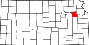
Grove Township
Shawnee County, Kansas
USA Kansas location map.svg
Red pog.svg
Grove Township
Location within the state of Kansas
Coordinates: 39°10′13″N95°51′24″W / 39.17028°N 95.85667°W / 39.17028; -95.85667
Country United States
State Kansas
County Shawnee
Area
  Total
30.0 sq mi (78 km2)
  Land29.9 sq mi (77 km2)
  Water0.1 sq mi (0.3 km2)
Population
 (2000)
  Total
473
  Density16/sq mi (6.1/km2)
Time zone UTC-6 (CST)
  Summer (DST) UTC-5 (CDT)

Grove Township is a township in Shawnee County, Kansas, United States. The population was 473 at the 2000 Census.

Contents

History

Grove Township was organized in 1918. [1]

Geography

According to the 2000 Census, the township had a total area of 30.1 square miles, of which 30.0 square miles (78 km2) is land area and 0.1 square miles (0.26 km2) is water.

Demographics

This township is part of the Topeka metropolitan area.

As of the 2000 Census, there were 473 people, 179 households, and 140 families residing in the township. The population density was 16 people per square mile. The racial makeup of the township was; White 96.8%, Black 0.8%, Native American 0.4%, Asian 0.8%, Other 0.4%.

In the township the median age for males was 36.1. The median age for females was 36.4.

Political districts

References

  1. Duncan, Spencer L. (2005). Historic Shawnee County: The Story of Topeka & Shawnee County. HPN Books. p. 74. ISBN   9781893619432.