Settlers came in the year 1856. The Sage and Bassett families in Dover came from Somersetshire, Bristol.
Dover was made a voting precinct of Auburn Township, October 1, 1860, and in the fall of 1867, was erected into a township. E.M. Hewins was the first trustee; Jacob Haskell and George Harden, justices. The first postmaster was Alfred Sage, appointed in 1862, and the family name, Sage, is still widespread in the area today.
During its peak years, Dover had a match factory, a wagon making business, two grist mills, two blacksmiths, an inn and stage coach station, livery stable, general store, three cheese factories. When looking at output figures, two of the largest cheese factories in the U.S. were in Dover.[3] The stone house cheese factory, built between 1856 and 1865 still stands today. The stone 1878 Sage Inn & Stage Coach Station, and the general store built in 1900 also survive.
Southwest Trail and the Sage Inn
The Southwest Trail was used as a connection from the Oregon Trail on its route through Topeka to the Santa Fe Trail in Council Grove. Today K-4, Kansas’ first paved highway, roughly follows the path of the trail. Along Mission Creek there were only two places where a wagon could ford the creek, one of which was at Dover. An inn was built at this location, which conveniently was also the natural half-way point of the trails two-day journey by horseback. The inn was an ideal stopping point to rest or trade out horses, get a bite to eat, and spend the night. Mark and John Sage, are believed to have crafted a stone building for their brother Alfred. Mark, especially, became a well-known stonemason in the area and built many of the stone farm houses, barns and bridges in Shawnee and Wabaunsee Counties in Kansas. The two brothers are also credited for their masonry work on the original Kansas Capitol (east wing) in Topeka from 1866 to 1869. The Sage Inn was built in two stages: The northern half of the current structure dates from 1865 and the southern half was built in 1878, after the Southwestern Stage Company was purchased by Root Brothers of Wichita Transfer Company. Around 1900, the railroad was built to Harveyville instead Dover. This was the clear end of the stagecoach era and the inn and station declined rapidly.
Filling station
A small Phillips 66 station was built In the late 1920s on the northwest corner of the K-4 intersection. It later became a Sinclair station. It is now no longer in operation as a filling station, but was once used as the base of the local volunteer fire department. The building was refurbished in the 1990s and today is used as an antiques and gift shop.
General store
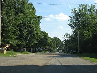
Downtown Dover looking west down modern day 57th Street. Year unknown.
This building was also built by Alfred Sage, and was christened Somerset Hall after his native home, Somersetshire, England. Most usually referred to it as Sage Hall though. The main floor was a general store and the second floor functioned as a community meeting hall.
In 1902, the I.O.O.F. (Oddfellows Lodge) began using the upstairs hall for their meetings, and three years later in 1905, the Oddfellows purchased the building from the Sage family upon Alfred's death. Members have met there monthly for one hundred years.
The first floor has in recent times doubled as a café, and has been operated by a series of owners who do not want to lose the heart of their Dover community.
In the Fall of 2008, Good Morning America ran a competition to determine the "Country's Best Pie." On November 16 it was announced one of the four finalist was Norma Grubb's "Coconut Cream Pie" from the Sommerset Hall Café. On Sunday, November 23 Norma's pie was declared the winner of the competition, determined by a national online vote.[4]
Historic people of Dover
James Bassett arrived in the area in 1857 from Onondaga County, New York. A native of England, he was born in Glastonbury, January 25, 1836. He was one of the organizers of the Dover State Bank, and was also among those who established the Dover Cemetery. Around the community he was lovingly referred to as "Uncle Jim."[5]
Harvey J. Loomis was born in Wadsworth, Ohio and came to Kansas in 1857. After the civil war he was made postmaster and established his office in the basement of his home. Later he was elected the first county assessor of Wabaunsee County. After serving for many years as township trustee, member of the school board and justice of the peace, was finally sent as representative of Wabaunsee County to the Kansas Legislature. He was a charter member of the Congregational Church at Dover. In 1872 he became a partner of George W. Daily, in a general store business.
Norma Grubb, age 88, was crowned "Pie Queen" by ABC's "Good Morning America" for her Coconut Cream Pie on November 23, 2008. At the time, she claimed to have baked 8,963 pies.[6]
Dover Federated Church
The Methodist, Baptist, and Congregational churches combined in 1921 to form the Federated Church of Dover, Kansas. The Church was called "federated" after the act of uniting on common agreement. The churches came together on a covenant of eight doctrines of basic, essential Christian faith. A quote in the Topeka Daily Capital attributed to Mr. Tabor described the union in this way, "In essentials, unity; in opinions, liberty; in all things, love."
Education
The community is served by Mission Valley USD 330 public school district. Mission Valley High School was built approximately 9 miles southwest of Dover on the geographic center of the three communities. Mission Valley East Grade School (Grades K-8) were also consolidated in 2003 when a new K-8 school was built onto Mission Valley High School.
Dover High School closed in 1970 when the school district consolidated with the towns of Harveyville and Eskridge in nearby Wabaunsee County. The Dover High School mascot was Tigers.
Related Research Articles
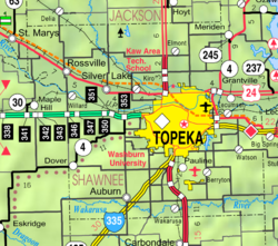
Topeka is the capital city of the U.S. state of Kansas and the county seat of Shawnee County. It is along the Kansas River in the central part of Shawnee County, in northeast Kansas, in the Central United States. As of the 2020 census, the population of the city was 126,587. The Topeka metropolitan statistical area, which includes Shawnee, Jackson, Jefferson, Osage, and Wabaunsee Counties, had a population of 233,870 in the 2010 census.
Wabaunsee County is a county located in the U.S. state of Kansas. Its county seat is Alma. As of the 2020 census, the county population was 6,877. The county was named for Chief Waubonsie of the Potawatomi Indians.
Shawnee County is located in northeast Kansas, in the central United States. Its county seat and most populous city is Topeka, the state capital. As of the 2020 census, the population was 178,909, making it the third-most populous county in Kansas. The county was one of the original 33 counties created by the first territorial legislature in 1855, and it was named for the Shawnee tribe.
Morris County is a county located in the U.S. state of Kansas. Its county seat and largest city is Council Grove. As of the 2020 census, the county population was 5,386. The county was named for Thomas Morris, a U.S. Senator from Ohio and anti-slavery advocate.
Scouting in Kansas has a long history, from the 1910s to the present day, serving thousands of youth in programs that suit the environment in which they live.
Harveyville is a city in Wabaunsee County, Kansas, United States. As of the 2020 census, the population of the city was 178. It is located 8.5 miles (13.7 km) northwest of the city of Burlingame.
Turner is a neighborhood within Kansas City, Kansas, United States. It was formerly an unincorporated community of Wyandotte County, similar to Piper, Kansas. Turner has its own school district, Turner USD #202.
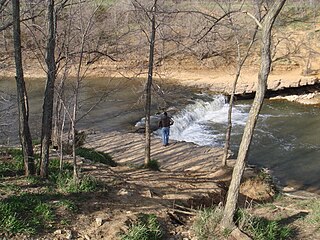
The Wakarusa River is a tributary of the Kansas River, approximately 80.5 miles (129.6 km) long, in eastern Kansas in the United States. It drains an agricultural area of rolling limestone hills south of Topeka and Lawrence.
Tecumseh is a census-designated place (CDP) in Shawnee County, Kansas, United States, and situated along the Kansas River. As of the 2020 census, the population was 696. The community and township are both named for the Shawnee chief.
The following television and radio stations serve the city of Topeka, Kansas, and surrounding areas.
Mission Creek is a water body west of Topeka, Kansas, United States. The 30-mile-long (48 km) tributary of the Kansas River goes through Wabaunsee County and Shawnee County, Kansas. Mission Creek was named for a Kaw mission near the banks.
Wabaunsee is a census-designated place (CDP) in Wabaunsee County, Kansas, United States. As of the 2020 census, the population was 104. It was named for former Pottawatomi chief Wabaunsee.
The Topeka Metropolitan Statistical Area, as defined by the United States Census Bureau, is an area consisting of five counties in northeastern Kansas, anchored by the city of Topeka. In total, it has an area of 3,290.15 square miles. As of the 2010 census, the MSA had a population of 233,870.
Wilmington is an unincorporated community in Wabaunsee County, Kansas, United States. It is located approximately 4 miles south of Harveyville, Kansas.
National Weather Service – Topeka, Kansas is a local National Weather Service forecast office based in Topeka, the state capital of Kansas. Its offices are located near Philip Billard Municipal Airport. It provides weather and emergency information to 23 counties in north-central, northeast, and east-central Kansas. Communities that rely on the Topeka Weather Office for forecasts and severe storm warnings include Abilene, Clay Center, Concordia, Council Grove, Emporia, Hiawatha, Junction City, Lawrence, Manhattan, Marysville, Ottawa, and Topeka.
K-31 is a 134-mile (216 km) long state highway in the U.S. state of Kansas. K-31 is signed as east–west from US-69 in Fulton to US-59 west of Kincaid and is signed as north–south from US-59 west of Kincaid to K-99 west of Harveyville. K-31 runs diagonally southeast–northwest, connecting small towns in east-central Kansas.
Mission Valley USD 330 is a public unified school district headquartered in Eskridge, Kansas, United States. The district includes the communities of Eskridge, Harveyville, Dover, Keene, Wilmington, and nearby rural areas.
This page is based on this Wikipedia article Text is available under the CC BY-SA 4.0 license; additional terms may apply. Images, videos and audio are available under their respective licenses.