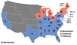
The 1856 United States presidential election was the 18th quadrennial presidential election, held on Tuesday, November 4, 1856. In a three-way election, Democrat James Buchanan defeated Republican nominee John C. Frémont and Know Nothing nominee Millard Fillmore. The main issue was the expansion of slavery as facilitated by the Kansas–Nebraska Act of 1854. Buchanan defeated President Franklin Pierce at the 1856 Democratic National Convention for the nomination. Pierce had become widely unpopular in the North because of his support for the pro-slavery faction in the ongoing civil war in territorial Kansas, and Buchanan, a former Secretary of State, had avoided the divisive debates over the Kansas–Nebraska Act by being in Europe as the Ambassador to the United Kingdom.

The 1860 United States presidential election was the 19th quadrennial presidential election, held on Tuesday, November 6, 1860. In a four-way contest, the Republican Party ticket of Abraham Lincoln and Hannibal Hamlin won a national popular plurality, a popular majority in the North where states already had abolished slavery, and a national electoral majority comprising only Northern electoral votes. Lincoln's election thus served as the main catalyst of the states that would become the Confederacy seceding from the Union. This marked the first time that a Republican was elected president. It was also the first presidential election in which both major party candidates were registered in the same home state; the others have been in 1904, 1920, 1940, 1944, and 2016.

Douglas County is a county located in the U.S. state of Colorado. As of the 2020 Census, the population was 357,978. The county is named in honor of U.S. Senator Stephen A. Douglas. The county seat is Castle Rock.

Douglas County is located in the U.S. state of Kansas. Its county seat and most populous city is Lawrence. As of the 2020 census, the county population was 118,785, making it the fifth-most populous county in Kansas. The county was named after Stephen Douglas, a U.S. Senator from Illinois and advocate for the popular sovereignty choice in the Kansas slavery debate.

Lawrence is a city in and the county seat of Douglas County, Kansas, United States, and the sixth-largest city in the state. It is in the northeastern sector of the state, astride Interstate 70, between the Kansas and Wakarusa Rivers. As of the 2020 census, the population of the city was 94,934. Lawrence is a college town and the home to both the University of Kansas and Haskell Indian Nations University.
Fort Belvoir is a United States Army installation and a census-designated place (CDP) in Fairfax County, Virginia, United States. It was developed on the site of the former Belvoir plantation, seat of the prominent Fairfax family for whom Fairfax County was named. It was known as Camp A. A. Humphreys from 1917 to 1935 and Fort Belvoir afterward.
The Wakarusa War was an armed standoff that took place in the Kansas Territory during November and December 1855. It is often cited by historians as the first instance of violence during the "Bleeding Kansas" conflict between anti-slavery and pro-slavery factions in the region.

Clinton Lake is a reservoir on the southwestern edge of Lawrence, Kansas. The lake was created by the construction of the Clinton Dam, and the 35 square miles (91 km2) of land and water is maintained by the U.S. Army Corps of Engineers.

Big Springs is an unincorporated community in northwest Douglas County, Kansas, United States.

The 1860 United States presidential election in Missouri took place on November 2, 1860, as part of the 1860 United States presidential election. Voters chose nine representatives, or electors to the Electoral College, who voted for president and vice president.

Lecompton Township is a township in Douglas County, Kansas, USA. As of the 2000 census, its population was 1,761.

Willow Springs Township is a township in Douglas County, Kansas, USA. As of the 2000 census, its population was 1,409. Willow Springs Township was formed in 1856. It was named after a small watering stop along the Santa Fe Trail.
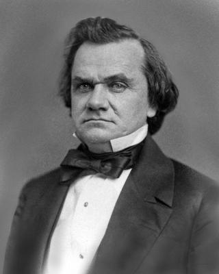
Stephen Arnold Douglas was an American politician and lawyer from Illinois. A senator, he was one of two nominees of the badly split Democratic Party for president in the 1860 presidential election, which was won by Republican candidate Abraham Lincoln. Douglas had previously defeated Lincoln in the 1858 United States Senate election in Illinois, known for the pivotal Lincoln–Douglas debates. He was one of the brokers of the Compromise of 1850 which sought to avert a sectional crisis; to further deal with the volatile issue of extending slavery into the territories, Douglas became the foremost advocate of popular sovereignty, which held that each territory should be allowed to determine whether to permit slavery within its borders. This attempt to address the issue was rejected by both pro-slavery and anti-slavery advocates. Douglas was nicknamed the "Little Giant" because he was short in physical stature but a forceful and dominant figure in politics.

Globe is an unincorporated community in Douglas County, Kansas, United States. It is located along U.S. Highway 56 in Marion Township. To the west of Globe is the Simmons Point Station.

Lake View is an unincorporated community in Douglas County, Kansas, United States. It is located 1 mile north of Lawrence.
Pleasant Grove is an unincorporated community in Douglas County, Kansas, United States. It is located four miles south of Lawrence.
Black Jack is an unincorporated community in Douglas County, Kansas, United States.
Media is a ghost town in Douglas County, Kansas, United States.
Lapeer is a ghost town in Douglas County, Kansas, United States.
Township 2 is a township in Rooks County, Kansas, United States.


