List of crossings of the River Weaver

Last updated

List of crossings of the River Weaver north of Nantwich. Bridges which only access the island between original course and Weaver Navigation are not included.


Key to heritage status
StatusCriteria [1]
IGrade I listed. Bridge of exceptional interest, sometimes considered to be internationally important
II*Grade II* listed. Particularly important bridge of more than special interest
IIGrade II listed. Bridge of national importance and special interest
Map all coordinates using: OpenStreetMap
CrossingDate Coordinates Heritage
status
LocalityNotesImage
Shrewbridge Road 53°03′17″N2°31′27″W / 53.0547°N 2.5243°W / 53.0547; -2.5243 (Shrewbridge Road) - Nantwich A530
Railway Bridge 53°03′42″N2°31′32″W / 53.0617°N 2.5256°W / 53.0617; -2.5256 (Nantwich Railway Bridge) -Nantwich Welsh Marches line Railway bridge over the Weaver in Nantwich - geograph.org.uk - 4702888.jpg
Nantwich Riverside South Footbridge 53°03′45″N2°31′33″W / 53.0625°N 2.5257°W / 53.0625; -2.5257 (Nantwich Footbridge) -Nantwich
Nantwich Riverside Footbridges 53°03′57″N2°31′30″W / 53.0659°N 2.5249°W / 53.0659; -2.5249 (Mill Island) -NantwichSeveral bridges accessing Mill Island
Nantwich Bridge [2] Early 19th Cent 53°04′03″N2°31′28″W / 53.0676°N 2.5245°W / 53.0676; -2.5245 (Nantwich Bridge) IINantwich Nantwich Bridge Welsh Row.jpg
Water Lode Bridge 53°04′11″N2°31′33″W / 53.0698°N 2.5259°W / 53.0698; -2.5259 (Water Lode Bridge) -Nantwich
Nantwich Riverside North Footbridges 53°04′22″N2°31′24″W / 53.0727°N 2.5233°W / 53.0727; -2.5233 (Nantwich Footbridges) -Nantwich3 Footbridges
Barony Road Bridge 53°04′40″N2°31′20″W / 53.0778°N 2.5222°W / 53.0778; -2.5222 (Barony Road Bridge) -NantwichB5074
Nantwich Bypass Bridge 53°04′44″N2°31′11″W / 53.0789°N 2.5196°W / 53.0789; -2.5196 (Nantwich Bypass Bridge) -Nantwich A51
Rail Bridge 53°06′25″N2°29′55″W / 53.107°N 2.4986°W / 53.107; -2.4986 (Crewe Rail Bridge) - Crewe North Wales Main Line
Church Minshull Aqueduct [3] 1833 53°07′36″N2°30′09″W / 53.1267°N 2.5026°W / 53.1267; -2.5026 (Church Minshull Aqueduct) II Church Minshull Shropshire Union Canal Shropshire Union aqueduct, Minshull Vernon.jpg
Farm Access Bridge 53°08′13″N2°30′05″W / 53.1369°N 2.5015°W / 53.1369; -2.5015 (Hoolgrave Access Bridge) -Church MinshullOld Hoolgrave access Bridge over the River Weaver, Church Minshull - geograph.org.uk - 5643099.jpg
Church Minshull Bridge [4] 53°08′31″N2°29′55″W / 53.1419°N 2.4985°W / 53.1419; -2.4985 (Church Minshull Bridge) IIChurch MinshullCross Lane Church Minshull Bridge.jpg
Footbridge 53°09′46″N2°29′29″W / 53.1629°N 2.4915°W / 53.1629; -2.4915 (Wimboldsley Footbridge) - Wimboldsley
Winsford High St Roundabout 53°11′33″N2°31′02″W / 53.1925°N 2.5171°W / 53.1925; -2.5171 (Winsford Road Bridge) - Winsford 2 Bridges Winsford Road Bridge - geograph.org.uk - 2424899.jpg
Weaver Parkway Footbridge [5] 53°12′52″N2°31′24″W / 53.2145°N 2.5233°W / 53.2145; -2.5233 (Weaver Parkway Footbridge) - Winsford
Vale Royal Locks [6] 1890 53°13′44″N2°32′24″W / 53.229°N 2.5401°W / 53.229; -2.5401 (Vale Royal Locks) II Hartford Footbridge on River, locks on Navigation Vale Royal Large Lock.jpg
Vale Railway Viaduct [7] 1837 53°13′54″N2°32′14″W / 53.2316°N 2.5372°W / 53.2316; -2.5372 (Vale Railway Viaduct) IIHartford West Coast Main Line River Weaver rail bridge - geograph.org.uk - 4149509.jpg
Hartford Bridge 53°14′16″N2°31′49″W / 53.2378°N 2.5303°W / 53.2378; -2.5303 (Hartford Bridge) -HartfordA556 Hartford Bridge - geograph.org.uk - 2424824.jpg
Hunt's Locks [8] 1890 53°15′08″N2°31′03″W / 53.2523°N 2.5175°W / 53.2523; -2.5175 (Hunt's Locks) II Northwich Locks on Navigation, Riversdale Bridge on River. The locks, Northwich - geograph.org.uk - 21868.jpg
Weaver Railway Viaduct [9] 1860 53°15′17″N2°30′51″W / 53.2547°N 2.5141°W / 53.2547; -2.5141 (Weaver Railway Viaduct) IINorthwich Mid-Cheshire line Northwich - Hunts Weir framed by railway viaduct - geograph.org.uk - 2902809.jpg
Hayhurst Bridge [10] 1899 53°15′30″N2°30′59″W / 53.2582°N 2.5164°W / 53.2582; -2.5164 (Hayhurst Bridge) IINorthwichSwing Bridge Hayhurst Swing Bridge, Northwich.jpg
Northwich Town Bridge [11] 1899 53°15′38″N2°30′58″W / 53.2605°N 2.516°W / 53.2605; -2.516 (Northwich Town Bridge) IINorthwichSwing Bridge Town Bridge - geograph.org.uk - 4012869.jpg
Winnington Turn Bridge [12] 1909 53°16′14″N2°32′20″W / 53.2705°N 2.5388°W / 53.2705; -2.5388 (Winnington Turn Bridge) II Winnington Swing Bridge Winnington Turn Bridge.jpg
Acton Bridge 53°16′48″N2°36′02″W / 53.2801°N 2.6005°W / 53.2801; -2.6005 (Acton Bridge) - A49 Swing Bridge A49 crossing R Weaver at Acton Bridge - geograph.org.uk - 5617274.jpg
Dutton Locks [13] 1874 53°17′15″N2°37′18″W / 53.2876°N 2.6218°W / 53.2876; -2.6218 (Dutton Locks) IIDutton Horse Bridge on River, locks on Navigation Towpath bridge, below Dutton Locks - geograph.org.uk - 5153705.jpg
Dutton Viaduct 1837 53°16′57″N2°37′41″W / 53.2826°N 2.628°W / 53.2826; -2.628 (Dutton Viaduct) II* West Coast Main Line Liverpool Branch The Dutton Viaduct - geograph.org.uk - 4071704.jpg
Frodsham Bridge [14] 1850 53°18′03″N2°42′24″W / 53.3009°N 2.7067°W / 53.3009; -2.7067 (Frodsham Bridge) II Frodsham Original River Frodsham Bridge.jpg
Sutton Weaver Swing Bridge 53°18′17″N2°41′57″W / 53.3048°N 2.6993°W / 53.3048; -2.6993 (Sutton Weaver Swing Bridge) -FrodshamWeaver Navigation Sutton Weaver swing bridge (13).JPG
Frodsham Viaduct [15] 1850 53°18′09″N2°42′32″W / 53.3025°N 2.7088°W / 53.3025; -2.7088 (Frodsham Viaduct) IIFrodshamOriginal River 175101 on Frodsham Viaduct.jpg
Frodsham Navigation Viaduct [16] 1850 53°18′22″N2°42′05″W / 53.306°N 2.7013°W / 53.306; -2.7013 (Frodsham Navigation Viaduct) IIFrodshamWeaver Navigation The Welsh Mountaineer crosses the Weaver Navigation at Frodsham, hauled by ex-LMS Class 8F 2-8-0 No. 48151.jpg
Weaver Viaduct 1971 53°18′30″N2°42′41″W / 53.3082°N 2.7114°W / 53.3082; -2.7114 (Weaver Viaduct) -Frodsham M56 M56 crossing the Weaver Navigation - geograph.org.uk - 5159471.jpg

Related Research Articles

<span class="mw-page-title-main">Sigourney Weaver</span> American actress (born 1949)

Susan Alexandra "Sigourney" Weaver is an American actress. A figure in science fiction and popular culture, she has received various accolades, including a British Academy Film Award, two Golden Globe Awards, and a Grammy Award, in addition to nominations for three Academy Awards, four Primetime Emmy Awards, and a Tony Award. In 2003, she was voted Number 20 in Channel 4's countdown of the 100 greatest movie stars of all time.

<span class="mw-page-title-main">Middleham Castle</span> 12th-century castle in Middleham, England

Middleham Castle is a ruined castle in Middleham in Wensleydale, in the county of North Yorkshire, England. It was built by Robert Fitzrandolph, 3rd Lord of Middleham and Spennithorne, commencing in 1190. The castle was the childhood home of King Richard III, although he spent very little of his reign there. The castle was built to defend the road from Richmond to Skipton, though some have suggested the original site of the castle was far better to achieve this than the later location. After the death of King Richard III the castle remained in royal hands until it was allowed to go to ruin in the 17th century. Many of the stones from the castle were used in other buildings in the village of Middleham.

<span class="mw-page-title-main">Nantwich</span> Market town in Cheshire, England

Nantwich is a market town and civil parish in the unitary authority of Cheshire East in Cheshire, England. It has among the highest concentrations of listed buildings in England, with notably good examples of Tudor and Georgian architecture. It had a population of 14,045 in 2021.

<span class="mw-page-title-main">River Weaver</span> River in Cheshire, England

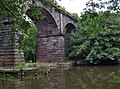
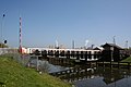
The River Weaver is a river, navigable in its lower reaches, running in a curving route anti-clockwise across west Cheshire, northern England. Improvements to the river to make it navigable were authorised in 1720 and the work, which included eleven locks, was completed in 1732. An unusual clause in the enabling Act of Parliament stipulated that profits should be given to the County of Cheshire for the improvement of roads and bridges, but the navigation was not initially profitable, and it was 1775 before the first payments were made. Trade continued to rise, and by 1845, over £500,000 had been given to the county.

<span class="mw-page-title-main">Northwich</span> Human settlement in England

Northwich is a market and port town and civil parish in the unitary authority of Cheshire West and Chester in the ceremonial county of Cheshire, England. It lies in the heart of the Cheshire Plain, at the confluence of the rivers Weaver and Dane. The town is about 18 miles (29 km) east of Chester, 15 miles (24 km) south of Warrington, and 19 miles (31 km) south of Manchester.

<span class="mw-page-title-main">Village weaver</span> Species of bird in the Ploceidae family

The village weaver , also known as the spotted-backed weaver or black-headed weaver, is a species of bird in the family Ploceidae found in much of sub-Saharan Africa. It has also been introduced to Portugal and Venezuela as well as to the islands of Hispaniola, Martinique, Puerto Rico, Mauritius and Réunion.

<span class="mw-page-title-main">Ethel Mairet</span> British hand loom weaver

Ethel Mary Partridge, Ethel Mary Mairet RDI, or Ethel Mary Coomaraswamy was a British hand loom weaver, significant in the development of the craft during the first half of the twentieth century.

<span class="mw-page-title-main">Weaverham</span> Human settlement in England

Weaverham is a village and civil parish in the Borough of Cheshire West and Chester and the ceremonial county of Cheshire in England. Just off the A49, it is just to the west of Northwich and south of the River Weaver, and has a population of 6,589, decreasing to 6,391 at the 2011 UK Census.

<span class="mw-page-title-main">Batherton</span> Rural civil parish in England

Batherton is a former civil parish, now in the parish of Stapeley and District, in the unitary authority area of Cheshire East and the ceremonial county of Cheshire, England. It lies immediately south of Nantwich and is jointly administered with the nearby settlement of Stapeley. In 2011 the parish had a population of 124. The River Weaver runs along the western boundary, and its floodplain provides a habitat for wetland species, including the great crested newt and the nationally rare black poplar.

<span class="mw-page-title-main">Straiton</span> Village in South Ayrshire, Scotland

Straiton is a village on the River Girvan in South Ayrshire in Scotland. It lies in the hills between Kirkmichael, Dalmellington, Crosshill, and Maybole.

<span class="mw-page-title-main">Wimboldsley</span> Human settlement in England

Wimboldsley is a village and former civil parish, now in the parish of Stanthorne and Wimboldsley, in the Cheshire West and Chester district, in the ceremonial county of Cheshire, England, 2 miles south of Middlewich. The population of the parish at the 2011 census was 153.

<span class="mw-page-title-main">Weaver Hall Museum and Workhouse</span> Historic site in Cheshire, England

The Weaver Hall Museum and Workhouse, Northwich, Cheshire, records the social, cultural and industrial history of west Cheshire. It was formerly known as the Salt Museum, reflecting its early focus on the history of salt extraction, a local industry dating back to Roman times. The museum was renamed Weaver Hall Museum and Workhouse in 2010 as its remit now extends to cover the broader history of the area and also the history of the building itself as a former workhouse.

<span class="mw-page-title-main">Sutton Weaver</span> Human settlement in England

Sutton Weaver is a village and civil parish in the unitary authority of Cheshire West and Chester, in the ceremonial county of Cheshire, England. It is 2 miles (3.2 km) northeast of Frodsham and 2.5 miles south of Runcorn. According to the United Kingdom Census 2011, it had a population of 495 and a total land area of 3,198 sq metres (m2) (thousands). The village has 206 Households with some of the main industries of the village being Wholesale and Retail Trade, Human Health and Social Work Activities and Manufacturing; These three sectors alone account for 36.5% of Occupational Share.

<span class="mw-page-title-main">Church Minshull</span> Human settlement in England

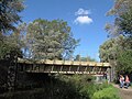
Church Minshull is a village and civil parish in the unitary authority of Cheshire East and the ceremonial county of Cheshire, England. The village is approximately 5 miles (8.0 km) north west of Crewe, just west of the River Weaver and Shropshire Union Canal. The principal road through Church Minshull is the B5074 between Nantwich and Winsford. The modern village centre is a designated conservation area which contains many houses of Tudor style architecture. A large area in the east of the parish falls within the Weaver Valley Area of Special County Value.

<span class="mw-page-title-main">Ten Bells</span> Pub in Spitalfields, London

The Ten Bells is a public house at the corner of Commercial Street and Fournier Street in Spitalfields in the East End of London. It is sometimes noted for its supposed association with at least two victims of Jack the Ripper: Annie Chapman and Mary Jane Kelly.

<span class="mw-page-title-main">Weavers' Triangle</span> Historic textile-producing area with a cotton museum in Lancashire, England

The Weavers' Triangle is an area of Burnley in Lancashire, England consisting mostly of 19th-century industrial buildings at the western side of town centre clustered around the Leeds and Liverpool Canal. The area has significant historic interest as the cotton mills and associated buildings encapsulate the social and economic development of the town and its weaving industry. From the 1980s, the area has been the focus of major redevelopment efforts.

<span class="mw-page-title-main">Queen Street Mill</span> Building in Harle Syke, to the north-east of Burnley, Lancashire

Queen Street Mill is a former weaving mill in Harle Syke, a suburb to the north-east of Burnley, Lancashire, that is a Grade I listed building. It now operates as a museum and cafe. Currently open for public tours between April and November. Over winter the café is opened on Wednesdays. It is also viewable with private bookings.

<span class="mw-page-title-main">Holy Trinity Church, Northwich</span> Church in Cheshire, England

Holy Trinity Church, Northwich, is in the Castle district of Northwich, Cheshire, England. It is an active Anglican parish church in the deanery of Middlewich, the archdeaconry of Chester, and the diocese of Chester. Its benefice is united with that of St Luke, Winnington, Northwich. The church is recorded in the National Heritage List for England as a designated Grade II listed building.

<span class="mw-page-title-main">Thornley-with-Wheatley</span> Human settlement in England

Thornley-with-Wheatley is a civil parish in the Borough of Ribble Valley, Lancashire, England. It is entirely rural, with no villages or other substantial settlements. Its population was 320 in 2011, a figure that has not changed much for over a century.

References

  1. Listed Buildings, English Heritage, archived from the original on 9 December 2012, retrieved 22 April 2011
  2. British Listed Buildings
  3. British Listed Buildings
  4. British Listed Buildings
  5. Weaver Parkway
  6. British Listed Buildings
  7. British Listed Buildings
  8. British Listed Buildings
  9. British Listed Buildings
  10. British Listed Buildings
  11. British Listed Buildings
  12. British Listed Buildings
  13. British Listed Buildings
  14. British Listed Buildings
  15. British Listed Buildings
  16. British Listed Buildings