List of dams in Gunma Prefecture

Last updated

Map of dams in Gunma Prefecture.(See Wikidata query)

The following is a list of dams in Gunma Prefecture, Japan.

Contents

List

NameLocationOpenedHeight (metres)Image
Aimata Dam   OOjs UI icon edit-ltr-progressive.svg 36°42′45″N 138°53′34″E [1] 195967 Aimata Dam.jpg
Akasan Choseichi Dam   OOjs UI icon edit-ltr-progressive.svg 36°44′59″N 138°53′16″E 196117.1
Dodairagawa Dam   OOjs UI icon edit-ltr-progressive.svg 36°14′6″N 138°40′41″E [1] 199270 Dodairagawa Dam and lake.jpg
Fujiwara Dam   OOjs UI icon edit-ltr-progressive.svg 36°48′16″N 139°2′12″E 1957 Fujiwara Dam.jpg
Funyūzawa Dam  OOjs UI icon edit-ltr-progressive.svg 36°28′32″N 139°5′48″E Funyuzawa Dam.jpg
Hayakawa Dam   OOjs UI icon edit-ltr-progressive.svg 36°26′5″N 139°15′49″E 194026 Hayakawa Dam and lake left view.jpg
Hiraide Dam   OOjs UI icon edit-ltr-progressive.svg 36°39′32″N 139°7′1″E [1] 196440 Hiraide Dam.jpg
Kajiyazawa Dam   OOjs UI icon edit-ltr-progressive.svg 36°34′20″N 138°43′16″E 192939.2
Kazawa Dam   OOjs UI icon edit-ltr-progressive.svg 36°29′11″N 138°28′16″E 192718.2 Kazawa Dam survey.jpg
Kirizumi Dam   OOjs UI icon edit-ltr-progressive.svg 36°22′8″N 138°42′3″E [1] 197559 Kirizumi Dam.jpg
Kiryugawa Dam   OOjs UI icon edit-ltr-progressive.svg 36°28′21″N 139°24′28″E [1] 198260.5 Kiryugawa Dam.jpg
Komori Dam   OOjs UI icon edit-ltr-progressive.svg 36°48′16″N 139°1′1″E 195833 Komori Dam (Gunma) and lake right view.jpg
Kurosakaishi Dam   OOjs UI icon edit-ltr-progressive.svg 36°34′34″N 139°24′35″E 198124 Kurosakaishi Dam and lake.jpg
Kusaki Dam   OOjs UI icon edit-ltr-progressive.svg 36°32′33″N 139°22′21″E 1976140 Kusaki-619-r1.JPG
Makabe Dam   OOjs UI icon edit-ltr-progressive.svg 36°29′8″N 139°2′37″E 192826.1
Marunuma Dam   OOjs UI icon edit-ltr-progressive.svg 36°49′26″N 139°20′23″E 193132.1 Marunumadam-2005-10-28 10-33-48 Fri -1130463228-.01.jpg
Mozawa Dam   OOjs UI icon edit-ltr-progressive.svg 36°28′14″N 138°59′25″E 197724.7
Nakagi Dam   OOjs UI icon edit-ltr-progressive.svg 36°19′7″N 138°44′43″E 195941 Nakagi Dam 2008-07-07.jpg
Nakanojo Dam   OOjs UI icon edit-ltr-progressive.svg 36°37′18″N 138°47′44″E [1] 196042 Nakanojo Dam.jpg
Naramata Dam   OOjs UI icon edit-ltr-progressive.svg 36°52′57″N 139°4′46″E 1990158 Naramata Dam.jpg
Narusawa Dam   OOjs UI icon edit-ltr-progressive.svg 36°23′20″N 138°56′47″E 194921 Narusawa Dam and lake right view.jpg
Nozori Dam   OOjs UI icon edit-ltr-progressive.svg 36°43′7″N 138°38′29″E 195644 Nozori Dam facing left view.jpg
Numata Dam [lower-alpha 1]   OOjs UI icon edit-ltr-progressive.svg 36°34′52″N 139°2′58″E Numata Dam site.jpg
Nyu Dam   OOjs UI icon edit-ltr-progressive.svg 36°15′39″N 138°49′55″E 195217.3 Nyu Dam 1975.jpg
Onita Dam   OOjs UI icon edit-ltr-progressive.svg 36°8′10″N 138°41′8″E [1] 200154.4
Oshio Dam   OOjs UI icon edit-ltr-progressive.svg 36°13′32″N 138°52′39″E 196531.9 Oshio Dam 1975.jpg
Otsu Dam   OOjs UI icon edit-ltr-progressive.svg 36°33′5″N 138°37′38″E 193119.6 Otsu Dam.jpg
Sakamoto Dam   OOjs UI icon edit-ltr-progressive.svg 36°21′12″N 138°42′27″E 36.3 [2] Lake Usui Sakamoto Dam.jpg
Sannakawa Dam   OOjs UI icon edit-ltr-progressive.svg 36°12′55″N 139°2′40″E 193319.7
Shimagawa Dam   OOjs UI icon edit-ltr-progressive.svg 36°41′47″N 138°46′53″E 199989.5 Shimagawa-626-r1.jpg
Shimokubo Dam   OOjs UI icon edit-ltr-progressive.svg 36°7′57″N 139°1′21″E 1968129 Shimokubo Dam.jpg
Shinaki Dam   OOjs UI icon edit-ltr-progressive.svg 36°37′41″N 138°38′4″E 196543.5 Shinaki Dam lake.jpg
Shinsui Dam   OOjs UI icon edit-ltr-progressive.svg 36°9′8″N 139°2′58″E [1] 20.5 [2] Shinsui-614-r1.JPG
Shiozawa Dam   OOjs UI icon edit-ltr-progressive.svg 36°7′34″N 138°53′23″E [1] 199538
Shirasuna Dam   OOjs UI icon edit-ltr-progressive.svg 36°39′1″N 138°38′59″E [2] 26.8 [2] Shirasuna Dam and lake.jpg
Sonohara Dam   OOjs UI icon edit-ltr-progressive.svg 36°38′20″N 139°10′31″E 196576.5 Sonohara-609-r1.jpg
Sudagai Dam   OOjs UI icon edit-ltr-progressive.svg 36°52′6″N 139°3′40″E 195572 Sudagai Dam.jpg
Takatsudo Dam   OOjs UI icon edit-ltr-progressive.svg 36°26′22″N 139°16′46″E [1] 29 [2] Takatsudo-616-r1.jpg
Takenuma Dam   OOjs UI icon edit-ltr-progressive.svg 36°14′10″N 139°1′22″E 196527.4 Takenuma Dam.jpg
Tambara Dam   OOjs UI icon edit-ltr-progressive.svg 36°46′29″N 139°3′47″E 1981 Tambara Dam right view.jpg
Tatezawagawa Dam  OOjs UI icon edit-ltr-progressive.svg 36°12′39″N 138°50′33″E [1]
Terazawa Dam   OOjs UI icon edit-ltr-progressive.svg 36°27′37″N 139°8′6″E 195215.5 Terazawa Dam right view.jpg
Ueno Dam   OOjs UI icon edit-ltr-progressive.svg 36°3′6″N 138°42′18″E 2004120 Ueno Dam.jpg
Ushimagusa Dam   OOjs UI icon edit-ltr-progressive.svg 36°12′48″N 139°2′6″E 195527.8
Yagisawa Dam   OOjs UI icon edit-ltr-progressive.svg 36°54′41″N 139°3′22″E 1967131 Yagisawa Dam 2.jpg
Yanba Dam   OOjs UI icon edit-ltr-progressive.svg 36°33′25″N 138°42′51″E [2] 1 Apr 2020131 Yanba Dam 2021-05 1.jpg

See also

Notes

  1. Dam project cancelled in 1972.

Related Research Articles

<span class="mw-page-title-main">Gunma Prefecture</span> Prefecture of Japan

Gunma Prefecture is a landlocked prefecture of Japan located in the Kantō region of Honshu. Gunma Prefecture has a population of 1,937,626 and has a geographic area of 6,362 km2. Gunma Prefecture borders Niigata Prefecture and Fukushima Prefecture to the north, Nagano Prefecture to the southwest, Saitama Prefecture to the south, and Tochigi Prefecture to the east.

<span class="mw-page-title-main">Numata, Gunma</span> City in Kantō, Japan

Numata is a city located in Gunma Prefecture, Japan. As of 31 July 2020, the city had an estimated population of 46,908 in 20,589 households, and a population density of 110 persons per km². The total area of the city is 443.46 square kilometres (171.22 sq mi), making it the largest city in terms of area within Gunma Prefecture.

<span class="mw-page-title-main">Fujioka, Gunma</span> City in Kantō, Japan

Fujioka is a city located in Gunma Prefecture, Japan. As of 1 August 2020, the city had an estimated population of 64,539 in 27,616 households, and a population density of 360 persons per km². The total area of the city is 180.29 square kilometres (69.61 sq mi).

<span class="mw-page-title-main">Tomioka, Gunma</span> City in Kantō, Japan

Tomioka is a city located in Gunma Prefecture, Japan. As of 1 September 2020, the city had an estimated population of 57,013 in 20,367 households, and a population density of 390 persons per km². The total area of the city is 122.85 square kilometres (47.43 sq mi). It is the location of the Tomioka Silk Mill, a UNESCO World Heritage Site.

<span class="mw-page-title-main">Annaka, Gunma</span> City in Kantō, Japan

Annaka is a city located in Gunma Prefecture, Japan. As of 31 July 2020, the city had an estimated population of 47,911 in 24,749 households, and a population density of 210 persons per square kilometre. The total area of the city is 276.31 km2 (106.68 sq mi).

<span class="mw-page-title-main">Kamikawa, Saitama</span> Town in Kantō, Japan

Kamikawa is a town located in Saitama Prefecture, Japan. As of 1 February 2021, the town had an estimated population of 13,369 in 5774 households and a population density of 280 persons per km2. The total area of the town is 47.40 square kilometres (18.30 sq mi).

<span class="mw-page-title-main">Ueno, Gunma</span> Village in Kantō, Japan

Ueno is a village located in Gunma Prefecture, Japan. As of 1 October 2020, the village had an estimated population of 1,149 in 571 households, and a population density of 6.3 persons per km2. The total area of the village is 181.85 square kilometres (70.21 sq mi). The village has the lowest population density of any municipality in Japan.

<span class="mw-page-title-main">Nakanojō, Gunma</span> Town in Kantō, Japan

Nakanojō is a town located in Gunma Prefecture, Japan. As of 1 August 2020, the town had an estimated population of 15,571 in 6737 households, and a population density of 35 persons per km². The total area of the town is 439.28 square kilometres (169.61 sq mi).

<span class="mw-page-title-main">Naganohara</span> Town in Kantō, Japan

Naganohara is a town located in Gunma Prefecture, Japan.

<span class="mw-page-title-main">Katashina, Gunma</span> Village in Kantō, Japan

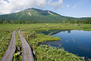
Katashina is a village located in Gunma Prefecture, Japan. As of 31 October 2020, the village had an estimated population of 4,314 in 1694 households, and a population density of 11 persons per km². The total area of the village is 391.76 square kilometres (151.26 sq mi). m². Much of the village is within the borders of Oze National Park.

<span class="mw-page-title-main">Minakami, Gunma</span> Town in Kantō, Japan

Minakami is a town located in Gunma Prefecture, Japan. As of 31 October 2020, the town had an estimated population of 18,383 in 7938 households, and a population density of 24 persons per km². The total area of the town is 781.08 square kilometres (301.58 sq mi). Much of the town is within the borders of Jōshin'etsu-kōgen National Park.

<span class="mw-page-title-main">Tone River</span> River in Kantō, Japan

The Tone River is a river in the Kantō region of Japan. It is 322 kilometers (200 mi) in length and has a drainage area of 16,840 square kilometers (6,500 sq mi). It is nicknamed Bandō Tarō ; Bandō is an obsolete alias of the Kantō Region, and Tarō is a popular given name for an oldest son. It is regarded as one of the "Three Greatest Rivers" of Japan, the others being the Yoshino in Shikoku and the Chikugo in Kyūshū.

<span class="mw-page-title-main">Naramata Dam</span> Dam in Gunma Prefecture, Japan.

Naramata Dam is a dam near Minakami, in the Gunma Prefecture of Japan. It supports a 12.2 MW hydroelectric power station.

<span class="mw-page-title-main">Shimokubo Dam</span> Dam in Gunma Prefecture, Japan.

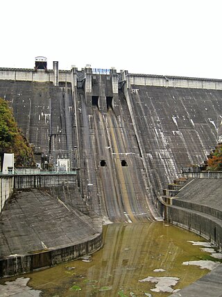
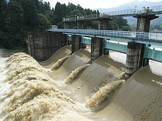
Shimokubo Dam is a dam in the Gunma Prefecture of Japan, completed in 1968.

<span class="mw-page-title-main">Aimata Dam</span> Dam in Gunma Prefecture, Japan

Aimata Dam (相俣ダム) is a dam built on the Akaya River, part of the class-A Tonegawa River system at Aimata in the city of Minakami, in the Tone District of Gunma Prefecture, Japan.

<span class="mw-page-title-main">Shinsui Dam</span> Dam in Gunma Prefecture, Japan.

Shinsui Dam is a dam in the Gunma Prefecture of Japan, completed in 1968.

<span class="mw-page-title-main">Shirasuna Dam</span> Dam in Gunma Prefecture, Japan.

Shirasuna Dam is a dam in the Gunma Prefecture of Japan, completed in 1940.

<span class="mw-page-title-main">Sudagai Dam</span> Dam in Gunma Prefecture, Japan.

Sudagai Dam is a dam in Minakami, in the Gunma Prefecture of Japan. It supports a 44.8 MW hydroelectric power station.

<span class="mw-page-title-main">Takatsudo Dam</span> Dam in Gunma Prefecture, Japan.

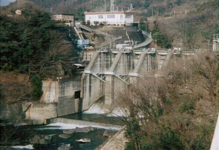
Takatsudo Dam (高津戸ダム) is a dam in Minakami, in the Gunma Prefecture of Japan, completed in 1973.

References

  1. 1 2 3 4 5 6 7 8 9 10 11 Geographic Names Server, Wikidata   Q1194038
  2. 1 2 3 4 5 6 Dams in Japan, Japan Dam Foundation, Wikidata   Q113763464