List of drainage basins of Lithuania

Last updated

There are six major drainage basins in Lithuania: the rivers Neman (Lithuanian:Nemunas), Lielupe, Venta, Daugava, Pregolya, and a strip along the Baltic where rivers flow directly into the sea. [1]

Lielupe river in Latvia

The Lielupe is a river in central Latvia. Its length is 119 km. The surface area of its drainage basin is 17,600 km². The average fall of the Lielupe is about and its average flow is 106 m³/s, although a maximum of 1380 m³/s has been reached during floods.

Venta (river) river in Latvia and Lithuania

The Venta is a river in north-western Lithuania and western Latvia. Its source is near Kuršėnai in the Lithuanian Šiauliai County. It flows into the Baltic Sea at Ventspils in Latvia.

Baltic Sea A sea in Northern Europe bounded by the Scandinavian Peninsula, the mainland of Europe, and the Danish islands

The Baltic Sea is a mediterranean sea of the Atlantic Ocean, enclosed by Denmark, Estonia, Finland, Latvia, Lithuania, Sweden, northeast Germany, Poland, Russia and the North and Central European Plain.

Contents

The Neman River drains 65.9% of Lithuania's territory Nemunas (Lithuania).png
The Neman River drains 65.9% of Lithuania’s territory

Neman basin

The Neman River, which drains into the Baltic Sea, drains 42,970 square kilometres within Lithuania (65.9% of its area). [1] The river rises in Belarus, southeast of Lithuania, and receives waters from the Šešupė River, which rises in Poland.

Belarus country in Eastern Europe

Belarus, officially the Republic of Belarus, formerly known by its Russian name Byelorussia or Belorussia, is a landlocked country in Eastern Europe bordered by Russia to the northeast, Ukraine to the south, Poland to the west, and Lithuania and Latvia to the northwest. Its capital and most populous city is Minsk. Over 40% of its 207,600 square kilometres (80,200 sq mi) is forested. Its major economic sectors are service industries and manufacturing. Until the 20th century, different states at various times controlled the lands of modern-day Belarus, including the Principality of Polotsk, the Grand Duchy of Lithuania, the Polish–Lithuanian Commonwealth, and the Russian Empire.

Poland Republic in Central Europe

Poland, officially the Republic of Poland, is a country located in Central Europe. It is divided into 16 administrative subdivisions, covering an area of 312,696 square kilometres (120,733 sq mi), and has a largely temperate seasonal climate. With a population of approximately 38.5 million people, Poland is the sixth most populous member state of the European Union. Poland's capital and largest metropolis is Warsaw. Other major cities include Kraków, Łódź, Wrocław, Poznań, Gdańsk, and Szczecin.

Lielupe

The Lielupe River flows into the Baltic Sea, while the Bullupe branch flows towards the Daugava River to the west. Lielupe Baltic Sea aerial.jpg
The Lielupe River flows into the Baltic Sea, while the Buļļupe branch flows towards the Daugava River to the west.

The Lielupe River basin encompasses 10,690 square kilometers within Lithuania. [1] The Lielupe flows northward into Latvia and into the Gulf of Riga, a bay of the Baltic Sea. Its tributaries include three rivers that rise in Lithuania (the Svete, Mūša, and Nemunėlis (Mēmele)). [1]

Latvia Republic in Northeastern Europe

Latvia, officially the Republic of Latvia, is a country in the Baltic region of Northern Europe. Since its independence, Latvia has been referred to as one of the Baltic states. It is bordered by Estonia to the north, Lithuania to the south, Russia to the east, and Belarus to the southeast, and shares a maritime border with Sweden to the west. Latvia has 1,957,200 inhabitants and a territory of 64,589 km2 (24,938 sq mi). The country has a temperate seasonal climate. The Baltic Sea moderates seasons, although it has four distinct ones and snowy winters.

Gulf of Riga A bay of the Baltic Sea between Latvia and Estonia

The Gulf of Riga, Bay of Riga, or Gulf of Livonia is a bay of the Baltic Sea between Latvia and Estonia.

Mūša river in Latvia

Mūša is a river in Northern Lithuania and Southern Latvia, having its confluence with river Nemunėlis, in Latvia, near city Bauska. Mūša is a tributary of the river Lielupė. The river is 164 kilometers long.

Venta

The Venta River rises in Lithuania, flows northward into Latvia, and discharges into the Baltic. It drains 5,930 square kilometers within Lithuania. [1]

Pregolya River

The Pregolya River (also known as the Pregel) flows in southwestern Lithuania near its border with the Kaliningrad Oblast, later entering the Baltic via the Vistula Lagoon. Its basin includes 70 square kilometers of Lithuanian territory. [1]

Pregolya River river in Kaliningrad Oblast, Russia

The Pregolya or Pregola is a river in the Russian Kaliningrad Oblast exclave.

Kaliningrad Oblast First-level administrative division of Russia

Kaliningrad Oblast, often referred to as the Kaliningrad Region in English, or simply Kaliningrad, is a federal subject of the Russian Federation that is located on the coast of the Baltic Sea. As an oblast, its constitutional status is equal to each of the other 85 federal subjects. Its administrative center is the city of Kaliningrad, formerly known as Königsberg. It is the only Baltic port in the Russian Federation that remains ice-free in winter. According to the 2010 census, it had a population of 941,873.

Vistula Lagoon fresh water lagoon on the Baltic Sea

The Vistula Lagoon is a brackish water lagoon on the Baltic Sea roughly 56 miles (90 km) long, 6 to 15 miles wide, and up to 17 feet deep, separated from Gdańsk Bay by the Vistula Spit. It is now known as the Vistula Bay or Vistula Gulf. The modern German name, Frisches Haff, is derived from an earlier form, Friesisches Haff.

Coastal basin

2,870 square kilometers of the country’s area drain directly into the Baltic. [1]

Related Research Articles

Geography of Ghana

Ghana is a country in Africa, along the Gulf of Guinea, just a few degrees north of the equator.

Geography of Latvia

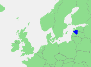
Latvia lies on the eastern shores of the Baltic Sea on the level northwestern part of the rising East European platform, between Estonia and Lithuania. About 98% of the country lies under 200 m (656 ft) elevation. With the exception of the coastal plains, the ice age divided Latvia into three main regions: the morainic Western and Eastern uplands and the Middle lowlands. Latvia holds over 12,000 rivers, only 17 of which are longer than 100 km (60 mi), and over 3,000 small lakes, most of which are eutrophic. The major rivers include the Daugava, the Lielupe, the Gauja, the Venta and the Salaca. Woodlands cover around 52% of the country. Other than peat, dolomite, and limestone, natural resources are scarce. Latvia has 531 km (330 mi) of sandy coastline, and the ports of Liepāja and Ventspils provide important warm-water harbors for the Baltic coast.

Geography of Lithuania

Lithuania is a country in the Baltic region of Europe. The most populous of the Baltic states, Lithuania has 262 km (163 mi) of coastline consisting of the continental coast and the "Curonian Spit" coast. Lithuania's major warm-water port of Klaipėda (Memel) lies at the narrow mouth of Curonian Lagoon, a shallow lagoon extending south to Kaliningrad and separated from the Baltic sea by Curonian Spit, where Kuršių Nerija National Park was established for its remarkable sand dunes.

Courland Place in Latvia

Courland, is one of the historical and cultural regions in western Latvia. The largest city is Liepāja, the third largest city in Latvia. The regions of Semigallia and Selonia are sometimes considered as part of Courland as they were formerly held by the same duke.

Neman Eastern—Northern European river

The Neman, Nemunas, Nyoman, Niemen or Memel, is a major Eastern European river. It rises in Belarus and flows through Lithuania before draining into the Curonian Lagoon, and then into the Baltic Sea at Rusnė Island. It begins at the confluence of two smaller tributaries, about 15 kilometers (9 mi) southwest of the town of Uzda in central Belarus, and about 55 km (34 mi) southwest of Minsk. In its lower reaches it forms the border between Lithuania and Russia's Kaliningrad Oblast. It also, very briefly, forms part of the Belarus–Lithuania border. The largest river in Lithuania, and the third-largest in Belarus, the Neman is navigable for most of its 900 km (560 mi) length.

Gdańsk Bay the bay in the Baltic Sea adjoining the port of Gdańsk and stretching to Kaliningrad

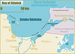
Gdansk Bay or the Bay of Gdansk Polish: Zatoka Gdańska; Kashubian: Gduńskô Hôwinga; Russian: Гданьская бухта, Gdan'skaja bukhta, and German: Danziger Bucht) is a southeastern bay of the Baltic Sea. It is named after the adjacent port city of Gdańsk in Poland and is sometimes referred to as the Gulf of Gdańsk.

East European Plain landscape

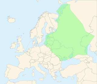
The East European Plain is a vast interior plain extending east of the North/Central European Plain, and comprising several plateaus stretching roughly from 25 degrees longitude eastward. It includes the westernmost Volhynian-Podolian Upland, the Central Russian Upland, and on the eastern border, encompasses the Volga Upland. The plain includes also a series of major river basins such as the Dnepr Basin, the Oka-Don Lowland, and the Volga Basin. Along the southernmost point of the East European Plain are the Caucasus and Crimean mountain ranges. Together with the North European Plain, and covering the Baltics, Moldova, south-eastern Romania, and its most southern expansion - the Danubian Plain in Northern Bulgaria,, it constitutes the majority of the Great European Plain, the greatest mountain-free part of the European landscape.

Semigallia Place in Latvia

Semigallia, also spelled Semigalia, is a historical region of Latvia, sometimes also including a part of Lithuania. It lies in the middle of the southern part of Latvia.

Nemunėlis river in Lithuania

Nemunėlis is a river in northern Lithuania and southern Latvia. It originates 6 km south of Rokiškis. It is 191 kilometres long before its confluence with the Mūša, near Bauska, forming the Lielupe.

Dubysa river

Dubysa, at 131 km, is the 15th longest river solely in Lithuania. It originates just a few kilometers from Lake Rėkyva near Šiauliai city. At first it flows south, but at Lyduvėnai turns southeast and near Ariogala - southwest. Dubysa is a Samogitian river. The first few kilometres of Dybysa are also known as Genupis or Šventupis.

Svete (river) river in Latvia

The Švėtė River flows through the Šiauliai and Joniškis districts in the northern part of Lithuania, and the southern part of Latvia. The source of the Švėtė is near Tulominai, about 16 km southeast of Kuršėnai, and the river flows north passing by Žagarė, near the Latvian border. It is a tributary of the Lielupe, joining it 8 km to the northwest of Jelgava. The Lielupe ultimately flows into the Baltic Sea.

Curonian Lagoon lagoon

The Curonian Lagoon is separated from the Baltic Sea by the Curonian Spit. Its surface area is 1,619 square kilometers (625 sq mi). The Neman River supplies about 90% of its inflows; its watershed consists of about 100,450 square kilometres in Lithuania and Russia's Kaliningrad Oblast.

Geography of Poland

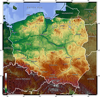
Poland is a country in East-Central Europe with an area of 312,679 square kilometres, and mostly temperate climate. Generally speaking, Poland is an almost unbroken plain reaching from the Baltic Sea in the north, to the Carpathian Mountains in the south. Within that plain, terrain variations run in bands east to west. The Baltic coast has two natural harbors, the larger one in the Gdańsk-Gdynia region, and a smaller one near Szczecin in the far northwest. The northeastern region, also known as the Masurian Lake District with more than 2,000 lakes, is densely wooded and sparsely populated. To the south of the lake district, and across central Poland a vast region of plains extends all the way to the Sudetes on the Czech and Slovak borders southwest, and to the Carpathians on the Czech, Slovak and Ukrainian borders southeast. The central lowlands had been formed by glacial erosion in the Pleistocene ice age. The neighboring countries are Germany to the west, the Czech Republic and Slovakia to the south, Ukraine and Belarus to the east, and Lithuania and the Russian exclave of Kaliningrad to the northeast.

References

  1. 1 2 3 4 5 6 7 "FAO's Information System on Water and Agriculture – Lithuania". FAO . Retrieved 2011-11-03.