
Transport in Pakistan is extensive and varied, and serves a population of over 240 million people. In recent years, new national highways have been built, with the addition of motorways which have improved trade and logistics within the country. Pakistan's rail network owned by Pakistan Railways is also undergoing expansion in recent years. Airports and seaports have been built with the addition of foreign and domestic funding. Transportation challenges in developing countries like Pakistan are escalating due to poor planning, inadequate governance, and corrupt practices. Consequently, these nations are grappling with a significant crisis in their transportation systems.

The East Coast Parkway is an expressway that runs along the southeastern coast of Singapore. It is approximately 20 kilometres (12 mi) in length. As of July 2022, it is Singapore's third-longest expressway.
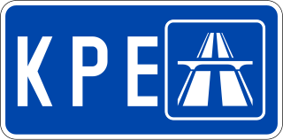
The Kallang–Paya Lebar Expressway (KPE) is the third newest of Singapore's network of expressways. The southern (Kallang) section of the expressway opened first, on 26 October 2007, with the remaining section opened on 20 September 2008.

The Damansara–Puchong ExpresswayDamansara–Puchong Expressway, abbreviated as LDP, is a 40.0-kilometre (24.9-mile) major controlled-access highway in the Petaling District of Selangor, Malaysia. The expressway runs in a north–south direction between Bandar Sri Damansara and Putra Permai, near Putrajaya, forming a major thoroughfare in the cities of Petaling Jaya and Puchong. A short east–west spur of the expressway connects Pusat Bandar Puchong to the suburb of UEP Subang Jaya.

Kuala Lumpur Middle Ring Road 2, Federal Route 28, is a ring road built by the Malaysian Public Works Department (JKR) to connect neighborhoods near the boundary of Federal Territory of Kuala Lumpur and Selangor. Altogether, the 65.0 km (40.4 mi) of the entire system consists of Federal Route 28, Damansara–Puchong Expressway Damansara–Puchong Expressway and Shah Alam Expressway Shah Alam Expressway. However, the Kuala Lumpur Middle Ring Road 2 is generally referred to as Route 28 since Route 28 occupies about two-thirds of the system.
Johor Bahru–Kota Tinggi Highway (Malay: Lebuhraya Johor Bahru–Kota Tinggi), Federal Route 3, also known as Tebrau Highway (Jalan Tebrau) and Jalan Kota Tinggi is a highway that encompasses Federal Route 3 in Johor Bahru, Malaysia. Part of Asian Highway Route AH18, the highway stretches from its southern end at Jalan Wong Ah Fook and Jalan Tun Abdul Razak in the metropolitan area of Johor Bahru to the northern end at the underpass flyover with North–South Expressway Southern Route and Johor Bahru Eastern Dispersal Link Expressway around Pandan. The stretch of Tebrau Highway after this continues as Jalan Pandan and Jalan Kota Tinggi respectively, beyond Pandan. The highway became the backbone of the Johor Bahru road system linking Pandan to the city centre, and to the Johor–Singapore Causeway, before being surpassed by the Johor Bahru Eastern Dispersal Link Expressway in 2012.
The Chennai Bypass Road is a full-access controlled expressway that interconnects four radial Indian National Highways around Chennai, India covering a distance of 32 km (20 mi) from Perungalathur on NH-32 to puzhal on NH-16 via Maduravoyal at a cost of ₹ 4.05 billion. Constructed as part of the National Highway Development Project to decongest the city of transiting vehicles, the expressway interconnects NH-32, NH-48, NH-716 and NH-16. This expressway now forms a part of the circular transportation corridor.

The Outer Ring Road System, or more commonly known as ORRS, is a network of major arterial roads in Singapore that forms a ring road through the towns along the city fringe. The ORRS is a semi-expressway, just like the West Coast Highway. Since 1994, roads along the ORRS have been upgraded in stages to provide a smoother route to travel across the island. Roads and interchanges along the ORRS are constantly being upgraded to cater to the ever increasing traffic demand. It starts as Portsdown Avenue in Queenstown and ends as Tampines Avenue 10 in Tampines. The series of roads passes through the areas of Queenstown, Bukit Timah, Central Catchment Nature Reserve, Bishan, Toa Payoh, Geylang and Tampines.
Woodsville Interchange is a major road interchange in Singapore. It marks the triple-point boundary of the planning areas of Kallang, Geylang and Toa Payoh.

The M-1 motorway or the Islamabad–Peshawar Motorway is an east–west motorway in Pakistan, connecting Peshawar to Islamabad–Rawalpindi.

The M-10 motorway or the Karachi Northern Bypass is a two-lane 57 km motorway in Karachi, Sindh, Pakistan. It connects the M-9 motorway to the Karachi Port, and provides an easy access to the transporters and to the commuters who can go directly to the Karachi port without entering the main arteries of city.

Faizabad Interchange is a cloverleaf interchange which serves as a junction between Islamabad Highway and Murree Road in Islamabad, Pakistan.
The city of Karachi is a major transport hub of Pakistan. The Karachi port and airport are major gateways to Pakistan. The Karachi Railway stations transports the major part of Pakistan's trade with other countries.

Islamabad is located in the Pothohar Plateau in the northern part of Pakistan, within the Islamabad Capital Territory. It is a well-organized city divided into different sectors and zones. It was ranked as a Gamma + world city in 2020. The city is home to Pakistan Monument, which is built on top of a hill in Shakarparian, and the Faisal Mosque, one of the largest mosques in South Asia and the sixth -largest mosque as per area in the world. The Capital Development Authority is tasked with developing the city and its facilities.

The transport system in Islamabad, the capital of Pakistan, connects it with all major cities and towns via regular trains and bus services running mostly from the neighbouring city of Rawalpindi.

The Islamabad Expressway, sometimes also referred to as Islamabad Highway, is a major north–south expressway in Islamabad, Capital Territory, Pakistan. The expressway provides quick access between the Islamabad and Rawalpindi, Punjab, connecting the national capital with the N-5 National Highway. It stretches from Zero Point Interchange with the Kashmir Highway in Islamabad to Rawat, Islamabad Capital Territory on the N-5 National Highway. The total length of the expressway is 28 kilometers (17 mi), with lanes varying from six to ten.

Amreli Steels Limited is a publicly held Pakistani company which manufactures steel rebars. It is based in Karachi, Pakistan.
Malir Expressway is a 39 km under construction expressway starting from KPT Interchange, passes through Qayyumabad and conclude at the Karachi-Hyderabad Motorway near Kathore, along the Malir River in Karachi, Pakistan. One of the major infrastructure developments in Karachi city which is unviable for the provincial government and detrimental to the city's climate. It was announced that half of it will be opened on 14 August 2023 which has been indefinitely delayed since the Asian Development Bank has withdrawn the funding for the construction ADB decides against financing Karachi’s Malir Expressway; as of right now there is illegal excavation happening on the Malir River bed and the fields of Malir; it is unlikely that Expressway will be completed given the litigation and damage to the only surviving river in Karachi.

The C-5 Southlink Expressway, signed as E2 of the Philippine expressway network, is a 7.708-kilometer (4.790 mi) controlled-access toll expressway in Metro Manila connecting the Manila–Cavite Expressway (CAVITEX) to the Circumferential Road 5 (C-5) in Taguig. The project is being built at the cost of ₱15 billion, and is a joint project of the Philippine Reclamation Authority, Toll Regulatory Board, and Cavitex Infrastructure Corporation, a subsidiary of Metro Pacific Investments Corporation. Currently operational between Taguig and near E. Rodriguez Avenue in Parañaque only, its remaining segment up to CAVITEX is currently under construction.
 Nagan Chowrangi Flyover, Karachi
 Azadi Chowk Flyover, Lahore
 Sufi Barkat Ali Flyover and Underpass, Faisalabad

