
Benazir Bhutto International Airport is an airport which formerly served the Islamabad-Rawalpindi metropolitan area. It was the second-largest airport by air traffic in Pakistan, until 12 May 2021 when it was replaced by the new Islamabad International Airport. Also known as Chaklala Airbase, it was renamed after the late Pakistani prime minister Benazir Bhutto (1953–2007) in June 2008. The airport handled 4,767,860 passengers in 2015–16, compared to 3,610,566 in 2010–11.

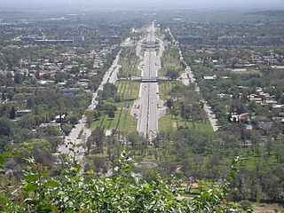
Blue Area is the central business district of Islamabad, Pakistan along the Jinnah Avenue. The area is a 2-kilometer (1.2 mi)-long corridor along Islamabad's Khayaban-e-Quaid-e-Azam, Islamabad's primary arterial road which leads up to the main government buildings. It is characterized by clean, wide roads and tall buildings among the panoramic greenery of the adjacent areas.

The M-9 motorway or the Karachi–Hyderabad motorway is a north–south motorway in the Sindh province of Pakistan, connecting Karachi to Hyderabad. The six-lane road is 136 kilometres long, and caters to the commercial traffic originating from the Karachi Port and Port Qasim. Daily traffic count is around 30,000.

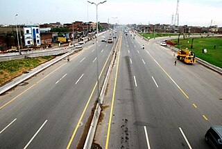
The M-2 Motorway or the Lahore–Islamabad Motorway is a north–south motorway in Pakistan, connecting Rawalpindi/Islamabad to Lahore, and is the first motorway to have been built in South Asia. The M-2 is 375 km long and located entirely in Punjab. It continues on to eventually become the M-1 motorway, which terminates in Peshawar. The M-2 crosses the junction of M-4 at Pindi Bhattian and M-3 at Dera Saithan Wala. The motorway is also a part of the Asian Highway AH1. The motorway was constructed during Prime Minister Nawaz Sharif's rule and cost over Rs. 60 billion and was opened in November 1997. One of the most expensive motorways in Asia, it also has one of the highest pillared-bridges in Asia at the Khewra Salt Range section.
The Lahore Ring Road is an 85-kilometer-long (53 mi) controlled-access, orbital highway located in Lahore, Pakistan. It links to the M-2 Motorway, the M-11 Motorway, and the N5 National Highway while going around the city of Lahore.

The M-1 motorway or the Islamabad–Peshawar Motorway is an east–west motorway in Pakistan, connecting Peshawar to Islamabad–Rawalpindi.

The M-10 motorway or the Karachi Northern Bypass is a two-lane 57 km motorway in Karachi, Sindh, Pakistan. It connects the M-9 motorway to the Karachi Port, and provides an easy access to the transporters and to the commuters who can go directly to the Karachi port without entering the main arteries of city.

Faizabad Interchange is a cloverleaf interchange which serves as a junction between Islamabad Highway and Murree Road in Islamabad, Pakistan.

Islamabad International Airport is the international airport serving Islamabad, the capital city of Pakistan and Rawalpindi. It is located 25 km (16 mi) south-west of the city, and is accessed via Srinagar Highway.

Islamabad is located in the Pothohar Plateau in the northern part of Pakistan, within the Islamabad Capital Territory. It is a well-organized city divided into different sectors and zones. It was ranked as a Gamma + world city in 2020. The city is home to Pakistan Monument, which is built on top of a hill in Shakarparian, and the Faisal Mosque, one of the largest mosques in South Asia and the sixth -largest mosque as per area in the world. The Capital Development Authority is tasked with developing the city and its facilities.
Seventh Avenue, also known as the Ahmed Nadeem Qasmi Avenue, is a signal free road located in Islamabad. It starts from the intersection on Khayaban-e-Iqbal near Islamabad Zoo, and ends at the intersection on Srinagar Highway.
The M-5 motorway, also known as Multan–Sukkur Motorway, is a north–south motorway in Pakistan, which connects Multan with Sukkur. The motorway is a 392 km long, high-speed, controlled-access, six-lane motorway that forms part of the China-Pakistan Economic Corridor.

The M-6 Motorway, or the Sukkur–Hyderabad Motorway, is an under-construction motorway project in Pakistan. It will connect Sukkur to Hyderabad. The 306 km long M-6 motorway is the only missing vital link of North to South connectivity, i.e. from Karachi to Peshawar. The motorway will cost approximately $1.7 billion to build. The M-6 will be a six-lane motorway with a design speed of 120 km/hour, 89 bridges, 15 interchanges and 243 underpasses.
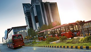
The Rawalpindi-Islamabad Metrobus is a 83.6 km (51.9 mi) bus rapid transit system operating in the Islamabad–Rawalpindi metropolitan area of Pakistan. It consists of four routes, namely the Red, Orange, Blue, and Green Lines. The Red and Orange Lines have dedicated lanes with proper stations built along them, while the Blue and Green Lines currently run along the Islamabad Expressway and Srinagar Highway respectively, with regular traffic.

The E-75 Expressway or Murree Expressway is a four-lane partially operational controlled-access expressway linking Islamabad to Murree in Punjab province. The second section between Murree and Muzaffarabad, Azad Jammu and Kashmir is currently under construction.

Peshawar Morr Interchange is Pakistan's biggest interchange in Islamabad, Pakistan. It is located at the intersection of Srinagar Highway and the Ninth Avenue, connecting the G and H sectors of Islamabad.

The M-14 Motorway, also known as the Islamabad–Dera Ismail Khan Motorway and the Hakla–Yarik Motorway, is a four-lane north–south motorway in Pakistan. The 285-kilometre-long (177 mi) motorway is a part of the Western Alignment of the China–Pakistan Economic Corridor, and offers high speed road connections between the Islamabad-Rawalpindi metropolitan area, and the southern parts of Khyber Pakhtunkhwa province around Dera Ismail Khan.
Zoji La Tunnel is an under-construction 9.5 m wide, 7.57 m high and 14.2 km long, horseshoe-shaped single-tube, 2 lane road tunnel at the height of 11,575 feet above sea level which passes under the Zoji La pass in the Himalayas between Ganderbal of Kashmir (J&K) and Drass town in Kargil district of Ladakh. The project cost for this smart tunnel (SCADA) system, constructed using the New Austrian tunneling method and equipped with CCTV, radio control, uninterrupted power supply, ventilation, etc is INR 8,308 crore as per 2021 estimates. Together with the adjacent Z-Morh Tunnel, this geostrategically important tunnel on the NH1 Srinagar-Leh Highway will provide year around weather-proof connectivity to Ladakh and Baltal, reduce the earlier 1-1.5 hours travel time to just 15 minutes drive, boost the tourism and economy, and enhance the logistics of the Indian Armed Forces. It is one of the 31 road tunnels being constructed at a combined cost of INR1400 billion.

The Margalla Avenue or Margalla Expressway is a 33-kilometer six-lane highway in the Margalla Hills area in the suburbs of Islamabad, Pakistan. It was planned in 1966, but work on it was stalled till 2021. The road is an alternative to the Srinagar Highway, and provides easy access of the tenth and eleventh sectors of Islamabad to the N-5 National Highway. This road is a crucial section of the larger Rawalpindi Ring Road project as it connects the town of Sangjani to the town of Barakahu.


