
The Dwight D. Eisenhower National System of Interstate and Defense Highways, commonly known as the Interstate Highway System, or the Eisenhower Interstate System, is a network of controlled-access highways that forms part of the National Highway System in the United States. The system extends throughout the contiguous United States and has routes in Hawaii, Alaska, and Puerto Rico.

The United States Numbered Highway System is an integrated network of roads and highways numbered within a nationwide grid in the contiguous United States. As the designation and numbering of these highways were coordinated among the states, they are sometimes called Federal Highways, but the roadways were built and have always been maintained by state or local governments since their initial designation in 1926.
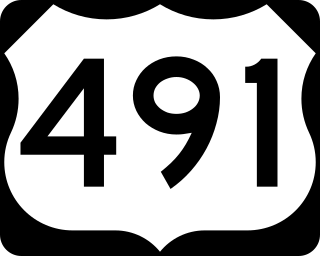
U.S. Route 491 (US 491) is a north–south U.S. Highway serving the Four Corners region of the United States. It was created in 2003 as a renumbering of U.S. Route 666 (US 666). With the US 666 designation, the road was nicknamed the "Devil's Highway" because of the significance of the number 666 to many Christian denominations as the Number of the Beast. This Satanic connotation, combined with a high fatality rate along the New Mexico portion, convinced some people the highway was cursed. The problem was compounded by persistent sign theft. These factors led to two efforts to renumber the highway, first by officials in Arizona, then by those in New Mexico. There have been safety improvement projects since the renumbering, and fatality rates have subsequently decreased.
A decommissioned highway is a highway that has been removed from service by being shut down, or has had its authorization as a national, provincial or state highway removed, the latter also referred to as downloading. Decommissioning can include the complete or partial demolition or abandonment of an old highway structure because the old roadway has lost its utility, but such is not always the norm. Where the old highway has continuing value, it likely remains as a local road offering access to properties denied access to the new road or for use by slow vehicles such as farm equipment and horse-drawn vehicles denied use of the newer highway.
On January 1, 1953, the New Jersey Highway Department renumbered many of the State Routes. This renumbering was first proposed in 1951 in order to reduce confusion to motorists. A few rules were followed in deciding what to renumber:

Texas state highways are a network of highways owned and maintained by the U.S. state of Texas. The Texas Department of Transportation (TxDOT) is the state agency responsible for the day-to-day operations and maintenance of the system. Texas has the largest state highway system, followed closely by North Carolina's state highway system. In addition to the nationally numbered Interstate Highways and U.S. Highways, the highway system consists of a main network of state highways, loops, spurs, and beltways that provide local access to the other highways. The system also includes a large network of farm to market roads that connect rural areas of the state with urban areas and the rest of the state highway system. The state also owns and maintains some park and recreational roads located near and within state and national parks, as well as recreational areas. All state highways, regardless of classification, are paved roads. The Old San Antonio Road, also known as the El Camino Real, is the oldest highway in the United States, first being blazed in 1691. The length of the highways varies from US 83's 893.4 miles (1,437.8 km) inside the state borders to Spur 200 at just 0.05 miles long.
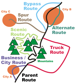
An official alternate route is a special route in the United States that provides an alternate alignment for a highway. They are loop roads and found in many road systems in the United States including the U.S. Highway system and various state and county route systems. Alternate routes were created as a means of connecting a town desired to be on a route that had been routed differently to put another important town or city on the route, or, in the case of the U.S. Highway system, as a means to eliminate divided routes.
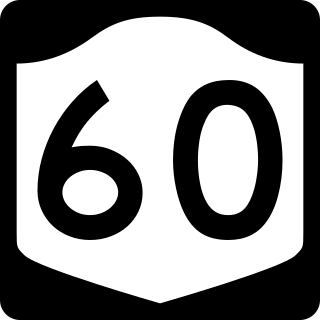
New York State Route 60 (NY 60) is a north–south state highway in Chautauqua County, New York, in the United States. The southern terminus of the route is at an intersection with U.S. Route 62 (US 62) south of the city of Jamestown in the town of Kiantone. Its northern terminus is at a junction with NY 5 in the city of Dunkirk. In between, NY 60 intersects the lengthy County Route 380 (CR 380) in Kiantone and Gerry, the Southern Tier Expressway in Ellicott, and the New York State Thruway (I-90) in the town of Dunkirk.

The North Carolina Highway System consists of a vast network of Interstate, United States, and state highways, managed by the North Carolina Department of Transportation. North Carolina has the second largest state maintained highway network in the United States because all roads in North Carolina are maintained by either municipalities or the state. Since counties do not maintain roads, there is no such thing as a "county road" within the state.

U.S. Route 1 (US 1) is a part of the U.S. Highway System that extends from Key West, Florida, to the Canada–United States border at Fort Kent, Maine. In the U.S. state of New York, US 1 extends 21.54 miles (34.67 km) from the George Washington Bridge in Manhattan to the Connecticut state line at Port Chester. It closely parallels Interstate 95 (I-95) for much of its course and does not serve as a major trunk road within the state. It is not concurrent with any other highways besides I-95 and (briefly) US 9, and few other state highways intersect it.
In road transportation in the United States, a special route is a road in a numbered highway system that diverts a specific segment of related traffic away from another road. They are featured in many highway systems; most are found in the Interstate Highway System, U.S. highway system, and several state highway systems. Each type of special route possesses generally defined characteristics and has a defined relationship with its parent route. Typically, special routes share a route number with a dominant route, often referred as the "parent" or "mainline", and are given either a descriptor which may be used either before or after the route name, such as Alternate or Business, or a letter suffix that is attached to the route number. For example, an alternate route of U.S. Route 1 may be called "Alternate U.S. Route 1", "U.S. Route 1 Alternate", or "U.S. Route 1A". Occasionally, a special route will have both a descriptor and a suffix, such as U.S. Route 1A Business.

An unsigned highway is a highway that has been assigned a route number, but does not bear road markings that would conventionally be used to identify the route with that number. Highways are left unsigned for a variety of reasons, and examples are found throughout the world. Depending on the policy of the agency that maintains the highway, and the reason for not signing the route, the route may instead be signed a different designation from its actual number, with small inventory markers for internal use, or with nothing at all.

U.S. Route 4 (US 4) is a part of the United States Numbered Highway System that runs from East Greenbush, New York, to Portsmouth, New Hampshire. In the U.S. state of New York, US 4 extends 79.67 miles (128.22 km) from an intersection with US 9 and US 20 in East Greenbush to the Vermont state line northeast of Whitehall. While the remainder of US 4 east of New York is an east–west route, US 4 in New York is signed north–south due to the alignment the route takes through the state. The portion of the route between Waterford and Whitehall is part of the Lakes to Locks Passage, an All-American Road.
U.S. Route 15 (US 15) is a part of the United States Numbered Highway System that runs from Walterboro, South Carolina, to Painted Post, New York. In the U.S. state of New York, US 15 extends 12.68 miles (20.41 km) through the Southern Tier from the Pennsylvania state line at Lindley north to an interchange with the Southern Tier Expressway (I-86/NY 17) just outside Painted Post. US 15 originally continued north to Rochester before being truncated to its present northern terminus. All of US 15 in New York was designated to Interstate 99 on June 27, 2014, and US 15 now runs concurrently with I-99.

New York State Route 273 (NY 273) was a state highway in northern Washington County, New York, in the United States. It began at an intersection with U.S. Route 4 (US 4) east of the village of Whitehall and ended at the Vermont state line in the town of Hampton, just east of a junction with NY 22A. The route passed through largely rural areas and entered only one community, the small hamlet of East Whitehall.

U.S. Highway 11 (US 11) is a part of the United States Numbered Highway System that spans 1,645 miles (2,647 km) from New Orleans, Louisiana, to Rouses Point, New York. Within the state of Louisiana, the highway travels 31 miles (50 km) from the national southern terminus at US 90 in New Orleans to the Mississippi state line south of Picayune.
Highways are split into at least four different types of systems in the United States: Interstate Highways, U.S. Highways, state highways, and county highways. Highways are generally organized by a route number or letter. These designations are generally displayed along the route by means of a highway shield. Each system has its own unique shield design that will allow quick identification to which system the route belongs.

