This article relies largely or entirely on a single source .(February 2008) |
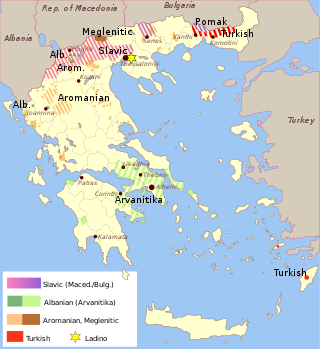
Many inhabited places in Imathia Prefecture of Greece have both Slavic and Greek forms. Some of the forms are identifiably of Greek origin, others of Slavic, yet others of Turkish or more obscure origins. Following the First World War and the Graeco-Turkish War which followed, the Greek government undertook a renaming program to place Greek names first on places with Turkophonic, and later on those with Slavophonic names. [1]
| Slavic name(s) | Current official name other Greek names | Prefecture | Geographic Coordinates | Citation [2] | Other |
|---|---|---|---|---|---|
| Ber (Бер) | Veria (Βέροια) | Imathia | 40°31′N22°12′E / 40.517°N 22.200°E | p. 6 | Capital of the Prefecture |
| Asamati (Асамати) | Asomata (Ασώματα) | Imathia | 40°29′N22°14′E / 40.483°N 22.233°E | p. 5 | |
| Barbesh, Kutlesh (Барбеш, Кутлеш) | Vergina (Βεργίνα) | Imathia | 40°29′N22°19′E / 40.483°N 22.317°E | p. 5 | Barbeş, Kütleş in Turkish |
| Boshtani (Боштани) | Rizomata (Ριζώματα) | Imathia | 40°21′N22°13′E / 40.350°N 22.217°E | p. 6 | |
| Branjate (Брањате) | Nea Nikomidia (Νέα Νικομήδεια) | Imathia | 40°35′N22°15′E / 40.583°N 22.250°E | p. 6 | |
| Bratinishta (Братиништа) | Charadra (Χαράδρα) | Imathia | 40°27′N22°16′E / 40.450°N 22.267°E | p. 6 | |
| Valoda (Валода) | Vromopegadon (Βρομοπήγαδον) | Imathia | 40°29′N22°08′E / 40.483°N 22.133°E | p. 7 | |
| Varvara (Варвара) | Agia Varvara, formerly Varvarae (Αγία Βαρβάρα, Βαρβάραι) | Imathia | 40°30′N22°15′E / 40.500°N 22.250°E | p. 7 | |
| Vosovo (Восово) | Sfikia (Σφηκιά) | Imathia | 40°23′N22°13′E / 40.383°N 22.217°E | p. 7 | |
| Gida (Гида) | Alexandria (Αλεξάνδρεια) | Imathia | 40°38′N22°27′E / 40.633°N 22.450°E | p. 8 | |
| Golem Alabor (Голем Алабор) | Prasinada, formerly Mega Alamporon (Πρασινάδα, Μέγα Αλάμπορον) | Imathia | 40°33′N22°31′E / 40.550°N 22.517°E | p. 8 | |
| Golemo Nishel (Големо Нишел) | Niselion (Νησέλιον) | Imathia | 40°35′N22°28′E / 40.583°N 22.467°E | p. 8 | Büyük Aynisel in Turkish |
| Gorna Luzhitsa (Горна Лужица) | Ano Tripotamon (Άνω Τριπόταμον) | Imathia | 40°29′N22°11′E / 40.483°N 22.183°E | p. 9 | |
| Grisel, Gridzhali (Грисел, Гриџали) | Agkathia (Αγκαθιά) | Imathia | 40°33′N22°28′E / 40.550°N 22.467°E | p. 9 | |
| Dobra, Bogoroditsa Dobra (Добра, Богородица Добра) | Kali Panagia (Καλή Παναγία) | Imathia | 40°33′N22°11′E / 40.550°N 22.183°E | p. 9 | |
| Dolyani (Долјани) | Koumaria (Κουμαριά) | Imathia | 40°31′N22°06′E / 40.517°N 22.100°E | p. 9 | |
| Dolna Luzhitsa (Долна Лужица | Kato Tripotamos, Tripotamia (Κάτω Τριπόταμος, Τριπόταμος) | Imathia | 40°30′N22°11′E / 40.500°N 22.183°E | p. 10 | |
| Dolno Kumanich (Долно Куманич) | Kato Komnenion (Κάτω Κομνήνειον) | Imathia | 40°31′N22°10′E / 40.517°N 22.167°E | p. 10 | |
| Drachkup (Драчкуп) | Daski, formerly Dratsikon (Δάσκιον, Δρατσικόν) | Imathia | 40°20′N22°10′E / 40.333°N 22.167°E | p. 10 | |
| Gjavato (Ѓавато) | Diavatos (Διαβατός) | Imathia | 40°33′N22°17′E / 40.550°N 22.283°E | p. 10 | |
| Izvor (Извор) | Lefkopetra, formerly Izvoros (Λευκόπετρα, Ίζβορος) | Imathia | 40°27′N22°13′E / 40.450°N 22.217°E | p. 11 | |
| Javornitsa (Јаворница) | Trilofo, formerly Nea Kuklena (Τρίλοφον, Νέα Κούκλενα) | Imathia | 40°34′N22°09′E / 40.567°N 22.150°E | p. 12 | |
| Janchishta (Јанчишта) | Agios Georgios, formerly Gianissa (Άγιος Γεώργιος, Γιάνισσα) | Imathia | 40°38′N22°12′E / 40.633°N 22.200°E | p. 12 | |
| Kaljani (Калјани) | Aloros (Άλωρος) | Imathia | 40°35′N22°36′E / 40.583°N 22.600°E | p. 12 | |
| Kapsohora (Капсохора) | Kapsochorion (Καψοχώριον) | Imathia | 40°37′N22°26′E / 40.617°N 22.433°E | p. 13 | |
| Karachali (Карачали) | Mavrodendrion (Μαυροδένδριον) | Imathia | 40°32′N22°14′E / 40.533°N 22.233°E | p. 13 | |
| Kirkasij (Киркасии) | Agia Trias (Αγία Τριάς) | Imathia | 40°33′N22°26′E / 40.550°N 22.433°E | p. 13 | |
| Klidi (Клиди) | Kleidi (Κλειδίον) | Imathia | 40°34′N22°36′E / 40.567°N 22.600°E | p. 14 | |
| Kokova, Kukova (Кокова, Кукова) | Polydendro (Πολύδενδρον) | Imathia | 40°25′N22°14′E / 40.417°N 22.233°E | p. 14 | |
| Kolura (Колура) | Kouloura (Κουλούρα) | Imathia | 40°33′N22°19′E / 40.550°N 22.317°E | p. 14 | |
| Kostohor, Kostemar (Костохор, Костемар) | Koutoschori, formerly Kostochori (Κουτσοχώριον, Κωστοχώρι) | Imathia | 40°32′N22°09′E / 40.533°N 22.150°E | p. 15 | |
| Kumanich (Куманич) | Komnenion, formerly Kumanitsion (Κομνήνειον, Κουμανίτσιον) | Imathia | 40°31′N22°10′E / 40.517°N 22.167°E | p. 16 | |
| Kumshtitsa, Kum Kjoj (Кумштица, Кум Ќој) | Palaios Ammos, formerly Ammos (Παλαιός Άμμος, Άμμος) | Imathia | 40°31′N22°16′E / 40.517°N 22.267°E | p. 16 | |
| Likovishta, Likovitsa, Stara Likovishta (Ликовишта, Ликовица, Стара Ликовишта) | Palaia Lykogianni, formerly Lykogianni (Παλαιά Λυκόγιαννη, Λυκόγιαννη) | Imathia | 40°36′N22°15′E / 40.600°N 22.250°E | p. 17 | |
| Ljanover (Лјановер) | Leianovergion (Λειανοβέργιον) | Imathia | 40°38′N22°31′E / 40.633°N 22.517°E | p. 17 | |
| Malo Alabor (Мало Алабор) | Mikron Alamporon, formerly Kydonia (Μικρόν Αλάμπορον, Κυδωνέα) | Imathia | 40°34′N22°31′E / 40.567°N 22.517°E | p. 18 | |
| Marusha (Маруша) | Marousia (Μαρούσια) | Imathia | 40°33′N22°04′E / 40.550°N 22.067°E | p. 19 | |
| Melik, Menlik (Мелик, Менлик) | Meliki (Μελίκη) | Imathia | 40°31′N22°24′E / 40.517°N 22.400°E | p. 19 | |
| Mech, Mezh (Меч, Меж) | Mesi, formerly Mesti (Μέσι, Μέστι) | Imathia | 40°32′N22°16′E / 40.533°N 22.267°E | p. 19 | |
| Mikrogush (Микрогуш) | Makrochori, formerly Mikroguzi (Μακροχώριον, Μικρογούζι) | Imathia | 40°34′N22°15′E / 40.567°N 22.250°E | p. 19 | |
| Mutsala (Муцала) | Kidonochorion, formerly Mustala, Mustalion (Κυδωνοχώριον, Μουσταλά, Μουσταλίον) | Imathia | 40°31′N22°14′E / 40.517°N 22.233°E | p. 20 | |
| Neohor (Неохор) | Neochori (Νεοχώριον) | Imathia | 40°39′N22°27′E / 40.650°N 22.450°E | p. 20 | |
| Neohorion (Неохорион) | Kypseli (Κυψέλη) | Imathia | 40°33′N22°29′E / 40.550°N 22.483°E | p. 20 | |
| Nisi (Ниси) | Nissi (Νησίον) | Imathia | 40°38′N22°23′E / 40.633°N 22.383°E | p. 21 | |
| Nihor, Nihorabali (Нихор, Нихорабали) | Neochoropoulon (Νεοχωρόπουλον) | Imathia | 40°36′N22°29′E / 40.600°N 22.483°E | p. 21 | |
| Nishel, Malo Nishel, Kuchuk Ajneshel (Нишел, Мало Нишел, Ќучук Ајнешел) | Niseloudi, formerly Niseloudion (Νησελούδι, Νησελούδιον) | Imathia | 40°35′N22°29′E / 40.583°N 22.483°E | p. 21 | Kuchuk Ayneshel in Turkish |
| Nov Prodrom (Нов Продром) | Neos Prodromos (Νέος Πρόδρομος) | Imathia | 40°33′N22°24′E / 40.550°N 22.400°E | p. 21 | |
| Nova Kumshtitsa (Нова Кумштица) | Neos Ammos (Νέος Άμμος) | Imathia | 40°30′N22°16′E / 40.500°N 22.267°E | p. 21 | |
| Nova Likovishta (Нова Ликовишта) | Nea Lykogianni (Νέα Λυκόγιαννη) | Imathia | 40°34′N22°15′E / 40.567°N 22.250°E | p. 22 | |
| Novo Skilich (Ново Скилич) | Neo Skillitsio, formerly Kalochorion (Νέον Σκυλλίτσιον, Καλοχώριον) | Imathia | 40°36′N22°22′E / 40.600°N 22.367°E | p. 22 | |
| Palatich (Палатич) | Palatitsia (Παλατίτσια) | Imathia | 40°29′N22°21′E / 40.483°N 22.350°E | p. 22 | |
| Paleohor, Palihor, Malo Palihor (Палеохор, Палихор, Мало Палихор) | Palaiochora (Παλαιόχορα) | Imathia | 40°35′N22°30′E / 40.583°N 22.500°E | p. 22 | |
| Paleohori (Палеохори) | Palaichorion (Παλαιοχώριον) | Imathia | 40°38′N22°29′E / 40.633°N 22.483°E | p. 22 | |
| Pozhari, Bugarin (Пожари, Бугарин) | Kefalochori (Κεφαλοχώριον) | Imathia | 40°34′N22°22′E / 40.567°N 22.367°E | p. 23 | |
| Prodrom (Продром) | Prodromos, formerly Palaios Prodromos (Πρόδρομος, Παλαιός Πρόδρομος) | Imathia | 40°32′N22°26′E / 40.533°N 22.433°E | p. 23 | |
| Sveti Ilija (Свети Илија) | Profetes Elias (Προφήτης Ελίας) | Imathia | 40°29′N22°15′E / 40.483°N 22.250°E | p. 24 | |
| Rapsomanik (Рапсоманик) | Rapsomanikion (Ραψομανίκιον) | Imathia | 40°33′N22°21′E / 40.550°N 22.350°E | p. 24 | |
| Rahova (Рахова) | Rachi, formerly Rachia (Ράχη, Ραχιά) | Imathia | 40°29′N22°13′E / 40.483°N 22.217°E | p. 24 | |
| Reshani (Решани) | Vrysaki (Βρυσάκιον) | Imathia | 40°38′N22°24′E / 40.633°N 22.400°E | p. 24 | |
| Sadena, Sadina (Садена, Садина) | Karavi (Καράβι) | Imathia | 40°32′N22°20′E / 40.533°N 22.333°E | p. 24 | |
| Sveta Marina (Света Марина) | Agia Marina (Αγία Μαρίνα) | Imathia | 40°36′N22°13′E / 40.600°N 22.217°E | p. 25 | |
| Svinishta, Svinche, Svintsa (Свиништа, Свинче, Свинца) | Sfina (Σφήνα) | Imathia | 40°33′N22°29′E / 40.550°N 22.483°E | p. 25 | |
| Skilich (Скилич) | Palaio Skillitsio, formerly Skillitsi (Σκυλλίτσι, Παλαιόν Σκυλλίτσιον) | Imathia | 40°37′N22°20′E / 40.617°N 22.333°E | p. 25 | |
| Sporlita, Spurlita (Спорлита, Спурлита) | Elafina (Ελαφίνα) | Imathia | 40°25′N22°19′E / 40.417°N 22.317°E | p. 26 | |
| Taramon, Teramon (Тарамон, Терамон) | Tagarochorion (Ταγαροχώριον) | Imathia | 40°34′N22°13′E / 40.567°N 22.217°E | p. 26 | |
| Topljani (Топлјани) | Gerogiani (Γεωργιανοί) | Imathia | 40°28′N22°10′E / 40.467°N 22.167°E | p. 27 | |
| Trihlovo, Trihlevo (Трихлово, Трихлево) | Trilofia (Τριλοφία) | Imathia | 40°33′N22°27′E / 40.550°N 22.450°E | p. 27 | |
| Trihovishta (Триховишта) | Kampochori (Καμποχώριον) | Imathia | 40°37′N22°22′E / 40.617°N 22.367°E | p. 27 | |
| Turkohor (Туркохор) | Patris, formerly Turkochorion (Πατρίς, Τουρκοχώριον) | Imathia | 40°34′N22°11′E / 40.567°N 22.183°E | p. 28 | |
| Tsrkovjani (Црковјани) | Mikra Santa, formerly Agios Ioannis (Μικρά Σάντα, Άγίος Ιωάννης) | Imathia | 40°24′N22°09′E / 40.400°N 22.150°E | p. 28 | |
| Chatal, Neohorudi (Чатал, Неохоруди) | Dhichali (Διχάλι) | Imathia | 40°36′N22°28′E / 40.600°N 22.467°E | p. 28 | |
| Chinar Furnos (Чинар Фурнос) | Platanos, formerly Tsinaforon (Πλάτανος, Τσινάφορον) | Imathia | 40°34′N22°33′E / 40.567°N 22.550°E | p. 28 | |
| Chornovo (Чорново) | Fytia (Φυτεία) | Imathia | 40°34′N22°07′E / 40.567°N 22.117°E | p. 28 |