Related Research Articles

The International Geophysical Year was an international scientific project that lasted from 1 July 1957 to 31 December 1958. It marked the end of a long period during the Cold War when scientific interchange between East and West had been seriously interrupted. Sixty-seven countries participated in IGY projects, although one notable exception was the mainland People's Republic of China, which was protesting against the participation of the Republic of China (Taiwan). East and West agreed to nominate the Belgian Marcel Nicolet as secretary general of the associated international organization.

The American Geophysical Union (AGU) is a 501(c)(3) nonprofit organization of Earth, atmospheric, ocean, hydrologic, space, and planetary scientists and enthusiasts that according to their website includes 130,000 people. AGU's activities are focused on the organization and dissemination of scientific information in the interdisciplinary and international fields within the Earth and space sciences. The geophysical sciences involve four fundamental areas: atmospheric and ocean sciences; solid-Earth sciences; hydrologic sciences; and space sciences. The organization's headquarters is located on Florida Avenue in Washington, D.C.

The TIMED mission is dedicated to study the influences energetics and dynamics of the Sun and humans on the least explored and understood region of Earth's atmosphere – the Mesosphere and Lower Thermosphere / Ionosphere (MLTI). The mission was launched from Vandenberg Air Force Base in California on 7 December 2001 aboard a Delta II rocket launch vehicle. The project is sponsored and managed by NASA, while the spacecraft was designed and assembled by the Applied Physics Laboratory at Johns Hopkins University. The mission has been extended several times, and has now collected data over an entire solar cycle, which helps in its goal to differentiate the Sun's effects on the atmosphere from other effects. TIMED Was Launched Alongside Jason-1.

Geco was a European geophysical service company specializing in seismic surveys for petroleum exploration. Starting operating in the North Sea from 1972, the company expanded to operate in most marine areas open for explorations, until Geco was incorporated into Geco-Prakla, with Schlumberger Limited as the solely owner from 1993.

Geophysical Research Letters is a biweekly peer-reviewed scientific journal of geoscience published by the American Geophysical Union that was established in 1974. The editor-in-chief is Harihar Rajaram.

The Journal of Geophysical Research is a peer-reviewed scientific journal. It is the flagship journal of the American Geophysical Union. It contains original research on the physical, chemical, and biological processes that contribute to the understanding of the Earth, Sun, and Solar System. It has seven sections: A, B, C (Oceans), D (Atmospheres), E (Planets), F, and G (Biogeosciences). All current and back issues are available online for subscribers.
Geosteering is the optimal placement of a wellbore based on the results of realtime downhole geological and geophysical logging measurements rather than three-dimensional targets in space. The objective is usually to keep a directional wellbore within a hydrocarbon pay zone defined in terms of its resistivity, density or even biostratigraphy. In mature areas, geosteering may be used to keep a wellbore in a particular section of a reservoir to minimize gas or water breakthrough and maximize economic production from the well. In the process of drilling a borehole, geosteering is the act of adjusting the borehole position on the fly to reach one or more geological targets. These changes are based on geological information gathered while drilling. Originally only a projected target would be aimed for with crude directional tools. Now the advent of rotary steerable tools and an ever-increasing arsenal of geophysical tools enables well placement with ever-increasing accuracy. Typically a basic tool configuration will have directional and inclination sensors, along with a gamma ray tool. Other options are neutron density, look ahead seismic, downhole pressure readings et al. Due to the vast volume of data generated, especially by imaging tools, the data transmitted to surface is a carefully selected fraction of what is available. Data is collected in memory for a data dump when back on surface with the tool.
DSOS was a real-time operating system developed by Texas Instruments' division Geophysical Services Incorporated (GSI) in the mid-1970s.

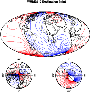
The World Magnetic Model (WMM) is a large spatial-scale representation of the Earth's magnetic field. It was developed jointly by the US National Geophysical Data Center and the British Geological Survey. The data and updates are issued by the US National Geospatial Intelligence Agency and the UK Defence Geographic Centre.
ION Geophysical provides acquisition equipment, software, planning and seismic processing services, and seismic data libraries to the global oil & gas industry. The company's technologies and services are used by E&P operators and seismic acquisition contractors to generate high-resolution images of the subsurface during exploration, exploitation and production operations. Headquartered in Houston, Texas, ION has offices in the United States, Canada, Latin America, Europe, Africa, Russia, China and the Middle East.

The focal mechanism of an earthquake describes the deformation in the source region that generates the seismic waves. In the case of a fault-related event it refers to the orientation of the fault plane that slipped and the slip vector and is also known as a fault-plane solution. Focal mechanisms are derived from a solution of the moment tensor for the earthquake, which itself is estimated by an analysis of observed seismic waveforms. The focal mechanism can be derived from observing the pattern of "first motions", that is, whether the first arriving P waves break up or down. This method was used before waveforms were recorded and analysed digitally and this method is still used for earthquakes too small for easy moment tensor solution. Focal mechanisms are now mainly derived using semi-automatic analysis of the recorded waveforms.

This list of 20th-century earthquakes is a global list of notable earthquakes that occurred in the 20th century. After 1900 most earthquakes have some degree of instrumental records and this means that the locations and magnitudes are more reliable than for earlier events. To prevent this list becoming unmanageable, only those of magnitude 6 and above are included unless they are notable for some other reason.
This is a list of free and open-source software for geophysical data processing and interpretation. The list is split into broad categories, depending on the intended use of the software and its scope of functions.

RadExPro is a Windows-based seismic processing software system produced by DECO Geophysical Software Company. It is suitable for field QC of 3D and 2D marine and on-land seismic data, advanced processing of HR/UHR offshore seismic, as well as for the onshore near-surface seismic reflection, refraction, MASW, and VSP processing.
Geosoft Incorporated is a software development and services company headquartered in Toronto, Canada. The company provides geophysical and geological software and geospatial server technology for professional geoscientists involved in natural resource exploration and related earth science disciplines.

Gerris is computer software in the field of computational fluid dynamics (CFD). Gerris was released as free and open-source software, subject to the requirements of the GNU General Public License (GPL), version 2 or any later.

GPlates is open-source application software offering a novel combination of interactive plate-tectonic reconstructions, geographic information system (GIS) functionality and raster data visualization.
EMIGMA is a geophysics interpretation software platform developed by Petros Eikon Incorporated for data processing, simulation, inversion and imaging as well as other associated tasks. The software focuses on non-seismic applications and operates only on the Windows operating system. It supports files standard to the industry, instrument native formats as well as files used by other software in the industry such as AutoCAD, Google Earth and Oasis montaj. There is a free version of EMIGMA called EMIGMA Basic developed to allow viewing of databases created by licensed users. It does not allow data simulation nor modeling nor data import. The software is utilized by geoscientists for exploration and delineating purposes in mining, oil and gas and groundwater as well as hydrologists, environmental engineers, archaeologists and academic institutions for research purposes. Principal contributors to the software are R. W. Groom, H. Wu, E. Vassilenko, R. Jia, C. Ottay and C. Alvarez.
MESA is a seismic survey design software currently owned by ION Geophysical. The software provides set of tools for optimizing onshore, offshore and transition zone survey design and planning. The software comes with three licenses namely, MESA field, MESA Professional and MESA Expert.