This is a list of the heritage sites in Limpopo as recognised by the South African Heritage Resources Agency.
| SAHRA identifier | Site name | Description | Town | District | NHRA status | Coordinates | Image |
|---|---|---|---|---|---|---|---|
| 9/2/210/0001 | Cycads, Modjadjiskraal, Bolobedu District | These striking plants occur in abundance on the slopes of what used to be regarded as the 'sacred mountain' in the Modjadji Reserve north-east of Polokwane. When observed superficially these plants with their bare stems and shiny, dark-green fern-like leaves look like palm trees, but they are actually not even related to any species of palm. They belong to the group of plants known as cycads (Cycczdales). A l Type of site: Tree. | Bolobedu | Provincial Heritage Site | 23°38′27″S30°19′44″E / 23.640940°S 30.328778°E |  | |
| 9/2/240/0003 | Baobab Trees, Messina District | These tropical deciduous trees with their gigantic shiny trunks, thin branches and delicate foliage are a distinctive element in the flora north of the Soutpansberg and give a special character to the plant life of the region. During the rainy season they in the district of Messina in the far northern extremity of the Transvaal there is a strange group of natural monuments. All the Baobab or 'Cream-of-Tartar' trees on the farms Vogelenzang, Messina, Singelele, Berkenrode, Prinzenhage, Stockford and Toynton Type of site: Tree. | Messina | Provincial Heritage Site | 22°22′59″S30°02′08″E / 22.383113°S 30.035462°E | 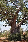 | |
| 9/2/243/0001 | Ana Trees, Rietfontein, Mokerong District | This clump of 'Ana Trees' or 'Apiesdoring' trees (Acacia albida Del.) stands in the Vaaltyn Makapan Reserve less than 16 km from Potgietersrust on the road to the Zaaiplaats tin mine. There are eight mature trees varying between 18 and 24 metres in height Ana trees occur widely in warm, humid localities along the rivers, from Damaraland to the Waterberg and further north. Although they are not a botanical rarity, they seldom occur in the Potgietersrust district. This group not only represents the largest i Type of site: Tree. | Mokerong | Provincial Heritage Site | 24°05′59″S28°54′42″E / 24.099770°S 28.911595°E | | |
| 9/2/253/0001 | Irish House, Market Street, Polokwane | Polokwane | Polokwane | Provincial Heritage Site | 23°54′41″S29°27′07″E / 23.911451°S 29.451829°E | | |
| 9/2/253/0002 | First National Bank, Landdros Mare Street, Polokwane | Type of site: Bank. | Polokwane | Polokwane | 23°54′07″S29°27′02″E / 23.902006°S 29.450639°E | | |
| 9/2/253/0004-001 | First Gold Crushing Site, Eersteling, Polokwane District | About 29 kilometres from Potgietersrust along the national road to Polokwane, a road turns off to the right and leads to Eersteling where one may still see the rock on which gold ore was first crushed in the Transvaal and the chimney of the first power pl The credit for the earliest discovery of gold in the Transvaal must go to Pieter Jacob Marais who, from 1853 onwards, found traces of alluvial gold in the Jukskei River and in the vicinity of Marabastad. After him, from 1868, Carl Mauch prospected for gol . | Polokwane | Provincial Heritage Site | 24°07′28″S29°16′04″E / 24.124501°S 29.267879°E | 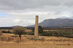 | |
| 9/2/253/0004-002 | First Gold Power Plant Site, Eersteling, Polokwane District | Polokwane | Provincial Heritage Site | 24°07′28″S29°16′04″E / 24.124503°S 29.267900°E | | ||
| 9/2/253/0007 | Fort Louis Campbell, Marabastad, Polokwane District | This English fort or earthworks is situated just east of the national road at Marabastad, a few kilometres south of Polokwane, on the farm Sand River. The British manned seven forts in the Transvaal during the First Transvaal War of Independence (1880–1881); they were situated at Pretoria, Potchefstroom, Rustenburg, Lydenburg, Wakkerstroom, Standerton and this one at Marabastad. After the Battle of Bron Type of site: Fort. | Polokwane | Provincial Heritage Site | 23°59′22″S29°21′19″E / 23.989449°S 29.355160°E | | |
| 9/2/257/0001 | Moorddrift Monument, Potgietersrus (Mokopane) District | This simple but important little monument stands under two large camelthorn trees beside the national road 16 km south of Potgietersrust, just where the road used to cross the Nyl River by a drift. It commemorates the murder of a number of settlers in thi One can only guess at the reasons for these tragic events, but it seems that a smouldering feud existed between Chief' Makapan's people and Field-Cornet Potgieter. In September 1854, twenty-eight settler men, women and children met their death in this vi Type of site: Memorial. | Potgietersrus | Provincial Heritage Site | 24°16′34″S28°58′28″E / 24.276165°S 28.974560°E | | |
| 9/2/257/0004 | Old Stone School, 97 Voortrekker Street, Potgietersrus | Type of site: School. | Potgietersrus | Potgietersrus | Provincial Heritage Site | 24°11′14″S29°00′39″E / 24.187209°S 29.010957°E | |
| 9/2/269/0002 | Schoemansdal, Louis Trichardt, Soutpansberg District | In 1848 Zoutpansberg, the most northerly Voortrekker village, was established here by followers of Chief Commandant A. H. Potgieter. The Chief Commandant died and was buried here in 1852. Later the town was named Schoemansdal after Commandant General Step. In 1848 Zoutpansberg, the most northerly Voortrekker village, was established here by followers of Chief Commandant A. H. Potgieter. The Chief Commandant died and was buried here in 1852. Later the town was named Schoemansdal after Commandant General Step | Soutpansberg | Provincial Heritage Site | 23°03′09″S29°46′12″E / 23.052500°S 29.770000°E | | |
| 9/2/269/0004 | Fosillised Footprints, Pontdrift, Soutpansberg District | These fossilised reptile footprints occur in sandstone where there was a dune in earlier times which was later covered by basalt flows. The animals of tile vicinity presumably fled to the dune where a large number of fossilised prints of various animals a Type of site: Trace fossils. These fossilised reptile footprints occur in sandstone where there was a dune in earlier times which was later covered by basalt flows. The animals of tile vicinity presumably fled to the dune where a large number of fossilised prints of various animals a | Soutpansberg | Provincial Heritage Site | 22°12′58″S29°08′18″E / 22.216127°S 29.138403°E | | |
| 9/2/269/0005 | Fort Hendrina, Louis Trichardt, Soutpansberg District | This movable iron fort dates from the 19th century and is the only example of its kind to be found in the Transvaal. Type of site: Fort. This movable iron fort dates from the 19th century and is the only example of its kind to be found in the Transvaal. | Soutpansberg | Provincial Heritage Site | 23°02′35″S29°54′31″E / 23.042994°S 29.908550°E | | |
| 9/2/269/0011 | Stonehenge, Bergvliet, Soutpansberg District | This farmhouse was erected for R. H. Stevens in about 1906 and is allegedly the oldest existing dwelling in the vicinity of Louis Trichardt. This farmhouse was erected for R. H. Stevens in about 1906 and is allegedly the oldest existing dwelling in the vicinity of Louis Trichardt. | Soutpansberg | Provincial Heritage Site | 23°01′25″S29°53′53″E / 23.023609°S 29.897963°E | | |
| 9/2/269/0023 | Lake Fundudzi, Ndzelele | Vhembe district | 22°51′05″S30°18′33″E / 22.8513220°S 30.3092190°E |  | |||
| 9/2/280/0004 | Blockhouse, Paul Sauer Road, Warmbaths | After the surrender of Pretoria in the Anglo-Boer War, the Republican forces adopted guerilla tactics. Built by the British authorities during the Anglo-Boer War to protect the railway from destruction by the Boers, it formed a part of a formidable line o Type of site: Blockhouse. After the surrender of Pretoria on the Anglo-Boer War, the Republican forces adopted guerilla tactics. To counter this the British forces erected a system of blockhouses to divide the combat areas into sectors. This blockhouse was part of one of the most | Warmbaths | Warmbaths | Provincial Heritage Site | 24°53′14″S28°17′57″E / 24.887148°S 28.299130°E | |
| 9/2/281/0003 | Old Reformed Church, Nylstroom | The historic old church building of the Waterberg Reformed Church was built in 1889 and was taken into use on 23 November of that year. President Paul Kruger of the Zuid-Afrikaansche Republiek was present on this occasion. During the Anglo-Boer War a wing Type of site: Church. The historic old church building of the Waterberg Reformed Church was built in 1889 and was taken into use on 23 November of that year. President Paul Kruger of the Zuid-Afrikaansche Republiek was present on this occasion. During the Anglo-Boer War a wing | Nylstroom | Waterberg | Provincial Heritage Site | 24°42′04″S28°24′13″E / 24.701110°S 28.403517°E | |
| 9/2/281/0004 | Strijdom House, Nylstroom | Advocate J. G. Strijdom, Prime Minister of South Africa from 1954 to 1958, lived in this house. The house was designed by Gerhard Moerdyk and is in the neo-Cape- Dutch style. Advocate J. G. Strijdom, Prime Minister of South Africa from 1954 to 1958, lived in this house. The house was designed by Gerhard Moerdyk and is in the neo-Cape- Dutch style. | Nylstroom | Waterberg | Provincial Heritage Site | 24°42′03″S28°24′10″E / 24.700838°S 28.402656°E | |