This is a list of the heritage sites in Knysna, situated in the Western Cape, as recognized by the South African Heritage Resources Agency. [1]
| SAHRA identifier | Site name | Description | Town | District | NHRA status | Coordinates | Image |
|---|---|---|---|---|---|---|---|
| 9/2/052/0001 | Old Gaol, Queen Street, Knysna | Type of site: Gaol | Knysna | Knysna | Provincial Heritage Site | 34°02′27″S22°59′58″E / 34.040866°S 22.999461°E | 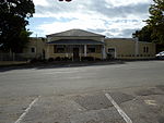 |
| 9/2/052/0002 | Old Rectory, Plettenberg Bay, Knysna District | Plettenberg Bay | Knysna |  Upload Photo | |||
| 9/2/052/0003 | Old Timber Store, Timber House Lot, Plettenberg Bay | As a result of Van Plettenberg’s visit and the glowing reports about the excellent forests around Plettenberg Bay, the Lords Seventeen instructed the authorities at the Cape to send a commission to inspect the forests of Outeniqualand and investigate the
| Plettenberg Bay | Knysna | Provincial Heritage Site | 34°03′24″S23°22′38″E / 34.056764°S 23.377313°E | 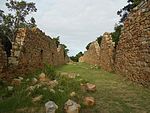 Type of site: Warehouse/storage area |
| 9/2/052/0003-001 | Van Plettenberg Beacon Replica, Plettenberg Bay | Type of site: Beacon | Plettenberg Bay | Knysna | Provincial Heritage Site | 34°03′26″S23°22′37″E / 34.057173°S 23.376908°E | |
| 9/2/052/0004 | Silviculturist Dwelling, Goldfield Forest Reserve, Homtini, Knysna | Homtini | Knysna | Upload Photo | |||
| 9/2/052/0005 | Silviculturist Dwelling, Witfontein Forest Reserve, Outeniqua, Knysna | Outeniqua | Knysna | Upload Photo | |||
| 9/2/052/0006 | Millwood House, Queen Street, Knysna | This historical cottage, built of wood and corrugated iron, is the only remaining building from the days of the discovery of gold at Millwood, Knysna which was proclaimed a gold field in 1886.
| Knysna | Knysna | Provincial Heritage Site | 34°02′27″S22°59′58″E / 34.040866°S 22.999461°E | 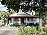 Type of site: House Previous use: House. Current use: Museum. This historical cottage, built of wood and corrugated iron, is the only remaining building from the days of the discovery of gold at Millwood, Knysna which was proclaimed a gold field in 1886. |
| 9/2/052/0007 | Silviculturist Dwelling, Knysna | Knysna | Knysna | Upload Photo | |||
| 9/2/052/0008 | Silviculturist Dwelling, Concordia, Knysna District | Concordia | Knysna | Upload Photo | |||
| 9/2/052/0009 | Silviculturist Dwelling, Diepwalle, Knysna District | Diepwalle | Knysna | Upload Photo | |||
| 9/2/052/0010 | Silviculturist Dwelling, Harkerville, Knysna District | Harkerville | Knysna | Upload Photo | |||
| 9/2/052/0011 | Silviculturist Dwelling, Farleigh, Knysna District | Farleigh | Knysna | Upload Photo | |||
| 9/2/052/0012 | Wall Painting, Farleigh Office, Knysna | Farleigh | Knysna | Upload Photo | |||
| 9/2/052/0013 | Silviculturist Dwelling, Plettenberg Bay, Knysna District | Plettenberg Bay | Knysna | Upload Photo | |||
| 9/2/052/0014 | Holy Trinity Church, Belvidere | This imposing little church was erected mainly through the enthusiasm and financial assistance of Thomas Henry Duthie. The foundation stone of this building was laid on 15 October 1851 and the church was consecrated on 15 October 1855 by Bishop Gray. The | Belvidere | Knysna | Provincial Heritage Site | 34°02′42″S22°59′50″E / 34.045041°S 22.997303°E |  Type of site: Church Current use: Church : Anglican. |
| 9/2/052/0014/01 | Old School, Erven 79 & 80, Belvidere, Knysna | Belvidere | Knysna | Upload Photo | |||
| 9/2/052/0015 | George Rex Mace, Knysna | Knysna | Knysna | Upload Photo | |||
| 9/2/052/0016 | St Andrews Church, Redbourne, Plettenberg Bay | A gravel road winds up the Piesang River Valley to the west of Plettenberg Bay, where it turns sharply to the right to mount a steep rise. A smaller farm road bears to the left and continues to follow the valley. The church was built in 1851 and is the oldest Anglican Church in the Diocese of George. In about 1846 William Henry Newdigate, a bachelor aged 21 years, came to South Africa from Warwickshire and bought a farm in the Piesang Valley (...). | Plettenberg Bay, Redbourne | Knysna | Provincial Heritage Site | 34°03′00″S23°22′00″E / 34.050000°S 23.366667°E |  Type of site: Church. Current use: Church : Anglican. |
| 9/2/052/0017 | Griqua Dwelling, Jackalskraal, Kranshoek, Knysna District | Kranshoek | Knysna | National Monument | Upload Photo | ||
| 9/2/052/0018 | School Building, Kranshoek, Knysna District | Kranshoek | Knysna | Pending Declaration | Upload Photo | ||
| 9/2/052/0019 | Griqua Independent Church of South Africa, Kranshoek, Knysna District | Kranshoek | Knysna | Upload Photo | |||
| 9/2/052/0020 | KNYSNA MUNICIPAL AREA, GENERAL | Knysna | Knysna | Upload Photo | |||
| 9/2/052/0022 | Knysna Heads, Knysna | Knysna | Knysna | 34°04′27″S23°03′50″E / 34.074182°S 23.063914°E | 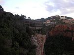 | ||
| 9/2/052/0022/001 | Erf 1403, Eastern Head, Knysna | This property is of importance because of its natural beauty; it forms part of the well-known Knysna Heads. | Knysna | Knysna | Provincial Heritage Site | 34°02′06″S23°02′47″E / 34.035086°S 23.046469°E |  |
| 9/2/052/0022/2 | Erf 1406, Eastern Head, Knysna | This property is of importance because of its natural beauty; it forms part of the well known Knysna Heads. | Knysna | Knysna | Provincial Heritage Site | 34°02′06″S23°02′47″E / 34.035086°S 23.046469°E | |
| 9/2/052/0022/3 | Erf 2238, Eastern Head, Knysna | Knysna | Knysna | Upload Photo | |||
| 9/2/052/0022/4 | Erf 1404, Knysna Heads, Knysna | Knysna | Knysna | Upload Photo | |||
| 9/2/052/0022/5 | Erf 4869, Knysna Heads, Knysna | Knysna | Knysna | Upload Photo | |||
| 9/2/052/0023 | PLETTENBERG BAY MUNICIPAL AREA, KNYSNA DISTRICT, GENERAL | Plettenberg Bay | Knysna | Upload Photo | |||
| 9/2/052/0024 | Settlement of the survivors of the Sao Gonzalo, Plettenberg Bay | Plettenberg Bay | Knysna | Upload Photo | |||
| 9/2/052/0025 | George Rex Slipway, Farm Westford, Knysna | Knysna | Knysna | Upload Photo | |||
| 9/2/052/0026 | Forest Hall, Knysna District | Type of site: House | Knysna | Provincial Heritage Site | 34°00′52″S23°03′15″E / 34.014408°S 23.054252°E | Upload Photo | |
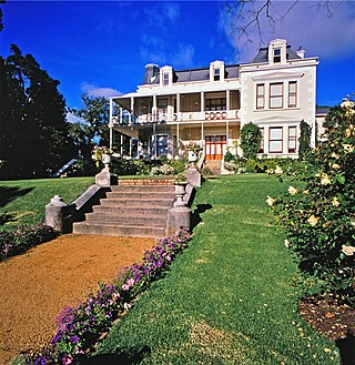
| 9/2/052/0027 | Belvidere House, Belvidere | Belvidere | Knysna | Provincial Heritage Site | 34°02′51″S22°59′52″E / 34.047596°S 22.997657°E | Upload Photo | |
| 9/2/052/0028 | Formosa Cottage, Plettenberg Bay, Knysna District | Plettenberg Bay | Knysna | Upload Photo | |||
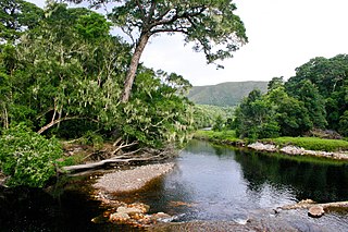
| 9/2/052/0029 | Robberg Nature Reserve, Plettenberg Bay | Type of site: Nature Reserve The land at the base of Robberg is rich in cultural history, especially from the Late Stone Age and the seventeenth-century settlement of survivors of the wreck of the Sao Goncalo. Environmentally it is of great importance as a buffer zone to the Robber | Plettenberg Bay | Knysna | Provincial Heritage Site | 34°06′19″S23°23′45″E / 34.105155°S 23.395815°E |  |
| 9/2/052/0030 | Anglo-Boer War Fort, Knysna | Type of site: Blockhouse | Knysna | Knysna | Provincial Heritage Site | 34°01′56″S23°02′38″E / 34.032104°S 23.043818°E | Upload Photo |
| 9/2/052/0031 | Hillview, Plettenberg Bay, Knysna District | Plettenberg Bay | Knysna | Upload Photo | |||
| 9/2/052/0032 | Public Library, Main Road, Knysna | Type of site: Library | Knysna | Knysna | Provincial Heritage Site | 34°02′10″S23°02′27″E / 34.036247°S 23.040944°E | 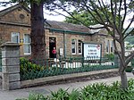 |
| 9/2/052/0033 | Grave of George Rex, Knysna | Knysna | Knysna | 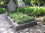 | |||
| 9/2/052/0034 | St George's Church, Church Street, Knysna | In 1828 the Government under Lord Charles Somerset drew up plans for a village on a portion of George Rex’s estate, which eventually developed into Knysna. Facing the road which later became the main street, George Rex gave a morgen of land (0,8 ha) as a | Knysna | Knysna | Provincial Heritage Site | 34°02′07″S23°03′02″E / 34.035219°S 23.050684°E | 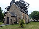 Type of site: Church Current use: Church : Anglican. This was the first church built in Knysna. The foundation stone was laid in 1849 and the church was consecrated by Bishop Robert Gray on 3 October 1855. |
| 9/2/052/0035 | Silviculturist Dwelling, Kaffirkop, Knysna District | Knysna | Knysna | Upload Photo | |||
| 9/2/052/0036 | WITTEDRIFT VILLAGE, KNYSNA DISTRICT, GENERAL | Knysna | Knysna | Upload Photo | |||
| 9/2/052/0038 | A A S le Fleur Monument, Monument Street, Kranshoek, Plettenberg Bay | Plettenberg Bay | Knysna | Upload Photo | |||
| 9/2/052/0039 | Grave of A A S le Fleur, Plettenberg Bay | Plettenberg Bay | Knysna | Upload Photo | |||
| 9/2/052/0040 | Thesen's Island, Knysna | Knysna | Knysna | 34°02′43″S23°02′54″E / 34.045354°S 23.048259°E | Upload Photo | ||
| 9/2/052/0041 | The Queen's Warehouse, Long Street, Knysna | Knysna | Knysna |  | |||
| 9/2/052/0042 | Knysna Quays Development, Knysna | Knysna | Knysna | 34°02′26″S23°02′42″E / 34.040547°S 23.044943°E | Upload Photo | ||
| 9/2/052/0043 | KNYSNA MAGISTERIAL DISTRICT, GENERAL | Knysna | Knysna | Upload Photo | |||
| 9/2/052/0044 | Railway Station Building, Rex Street, Knysna | Knysna | Knysna | Upload Photo | |||
| 9/2/052/0045 | KRANSHOEK LOCAL AREA, GENERAL | Kranshoek | Knysna | Upload Photo | |||
| 9/2/052/0046 | BELVIDERE LOCAL AREA, GENERAL | Belvidere | Knysna | Upload Photo | |||
| 9/2/052/0047 | East Guanogat Cave, Robberg Peninsula, Plettenberg Bay | Plettenberg Bay | Knysna |  | |||
| 9/2/052/0048 | Westford, Farm 191, Knysna District | Knysna | Knysna | Upload Photo |